

July 24: Rainfall Update
Discussion: The synoptic rain system, that kicked the warm and muggy pattern off this past Saturday, verified W of it’s modeled track. This was the result of more phasing activity between the upper-level low and coastal surface low. While New Jersey still saw a dumping, the heaviest precipitation went west with the phase. The surface low verified a few mb deeper and the area of greatest convergence settled in between the Delaware River and State College, PA. This area of convergence has been dominating the rainfall headlines in E/C PA. Most of SENJ has remained rain-free but muggy since. Parts of CNJ and NNJ have seen numerous popcorn showers.
As the SE US upper-level low absorbs into another upper-level low approaching from S Canada, the high just NE of Bermuda will flex it’s anticyclonic return flow. The jet pattern will remain meridional but New Jersey should see a change in flow direction from S/SE to S/SW. This is expected to bring that greatest area of convergence (lifting) eastward over New Jersey tomorrow (Wednesday). This presents a greater rain threat between tomorrow afternoon and Thursday morning. The atmosphere is deeply-saturated with precipitable water and it won’t take much lift to squeeze it out.
The strange thing I’m seeing is most of New Jersey is being robbed of precipitation tomorrow night. It’s probably still going to rain but most of New Jersey might only see between a half-inch and 1.5 inches of rainfall. This compared to the 3-5+ inches of rainfall modeled just a few days ago can make the difference between minor and major flash flooding. The modeled reason for the lesser rainfall is due to subsidence over New Jersey counteracting from more lifting in PA. The additional PA lifting is aligned with peak diurnal surface heating. Anything that helps to increase lift in PA will increase subsidence (sinking air) over New Jersey. We’re going to have to wait and play this out. But it does look like less rain could fall tomorrow night into Thursday morning. There is time for this trend to reverse but so far it is holding.
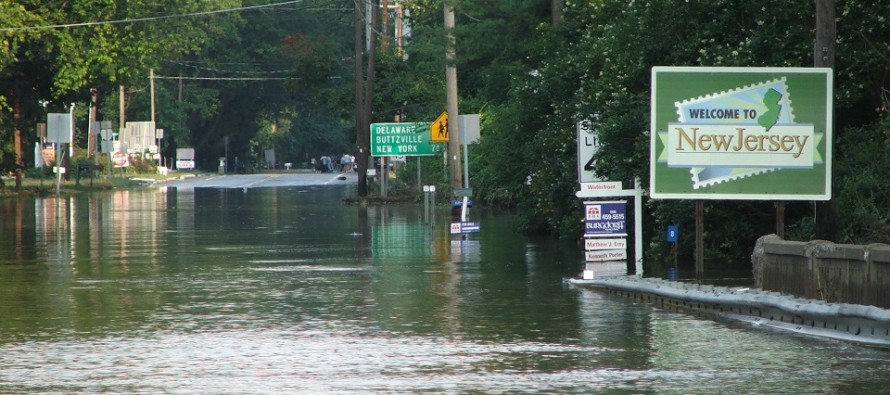
We’re still likely on the hook for periods of good soaking. We still might see a few thunderstorms embed into the axis of greatest convergence. The lesser rain scenario would take us off the hook for the “rivers in the roads” video you’ve seen out of PA the past few days.
As a new upper-level low dives in from S Canada, it will direct it’s 500mb flow into the W Atlantic ridge. This should temporarily bump the Bermuda high E for this coming weekend. Assuming this happens we should see a much drier weekend with average temperatures and slightly-reduced humidity. The chance of rain would be reduced to an isolated chance rather than widespread or even scattered.
In English: It’s probably going to rain between tomorrow (Wednesday) afternoon and Thursday morning. You might see thunderstorms embedded within the rain. The good news is that most of New Jersey should max out around 1.5 inches of rainfall from the entire period. Maybe 2 inches worst case scenario for western NJ counties (Salem/NWNJ). Many locations could see less than an inch and in some cases less than a half-inch. While this could still produce a localized flash flooding environment, it would not be bad as the 6 inch+ scenario that parts of PA have seen the past few days. You might have seen some images and video of such on social media. The weekend is looking much better than it did a week ago. Still the chance for an isolated shower or thunderstorm on either Saturday or Sunday but nothing widespread. Saturday and Sunday should offer a slight reduction in humidity as well. The full and detailed weekend outlook will be out Thursday evening. Have a great Tuesday night and be safe! JC
Jonathan Carr (JC) is the founder and sole operator of Weather NJ, New Jersey’s largest independent weather reporting agency. Since 2010, Jonathan has provided weather safety and forecasting services for New Jersey and immediate surrounding areas through the web, social media, and app spaces. Originally branded as Severe NJ Weather (before 2014), Weather NJ is proud to bring you accurate and responsible discussions ahead of high-stakes weather scenarios that impact the garden state. All Weather. All New Jersey.™


LOCAL FORECAST | INTERACTIVE RADAR | LATEST NJ WEATHER ALERTS | WEDDING FORECAST| PRIVACY POLICY
© Copyright 2024 Weather NJ LLC. All Rights Reserved.
Some information that can be found on our website is provided by a private weather station and is not an officially recognized station for weather reporting. Though we always strive to achieve accurate reporting for our own use, it is important that you do NOT depend on the data provided here for any purpose.
