

July 29: It’s Gonna Be a Hot One Today!
The National Weather Service has issued Excessive Heat Warnings and Air Quality Alerts with good reason. Today’s temperatures should easily soar into the 90s for many with heat indices approaching 100. When the low-to-mid levels of the atmosphere are this warm, pollution has trouble rising and escaping the lower-levels where most of us live. This is especially a problem along the heavily-populated and industrialized I-95 corridor running through Philadelphia and New York City (ultimately extended to DC-Boston). That’s why you’ll generally see air quality alerts favor such urban areas during extreme heat. This struggle for pollutants/exhaust to rise is similar in physics to the capping inversion which prevents thunderstorm formation on a warm day. With that said, the cap is always vulnerable to breaking as we saw yesterday in parts of SENJ. That’s also very possible today.
Let’s look at some high-res guidance. Here’s the latest NAM showing peak afternoon surface temperatures (around 2PM). Keep in mind that heat indices will be 5-10 degrees higher when factoring humidity:
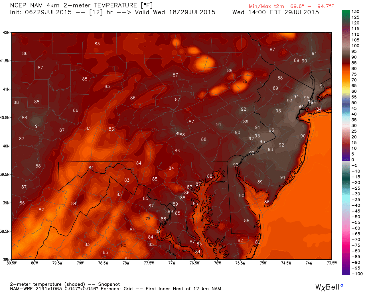
This much diurnal surface heating coupled with high dew points creates a lot of potential fuel for any thunderstorms that do form. The question is, will the atmosphere provide a match to light it? What I mean by that is a trigger such as a cold front, warm front, surface low disturbance, etc. Well none of those are scheduled to move through today so much of this fuel will be wasted. Here are the projected surface instability numbers:
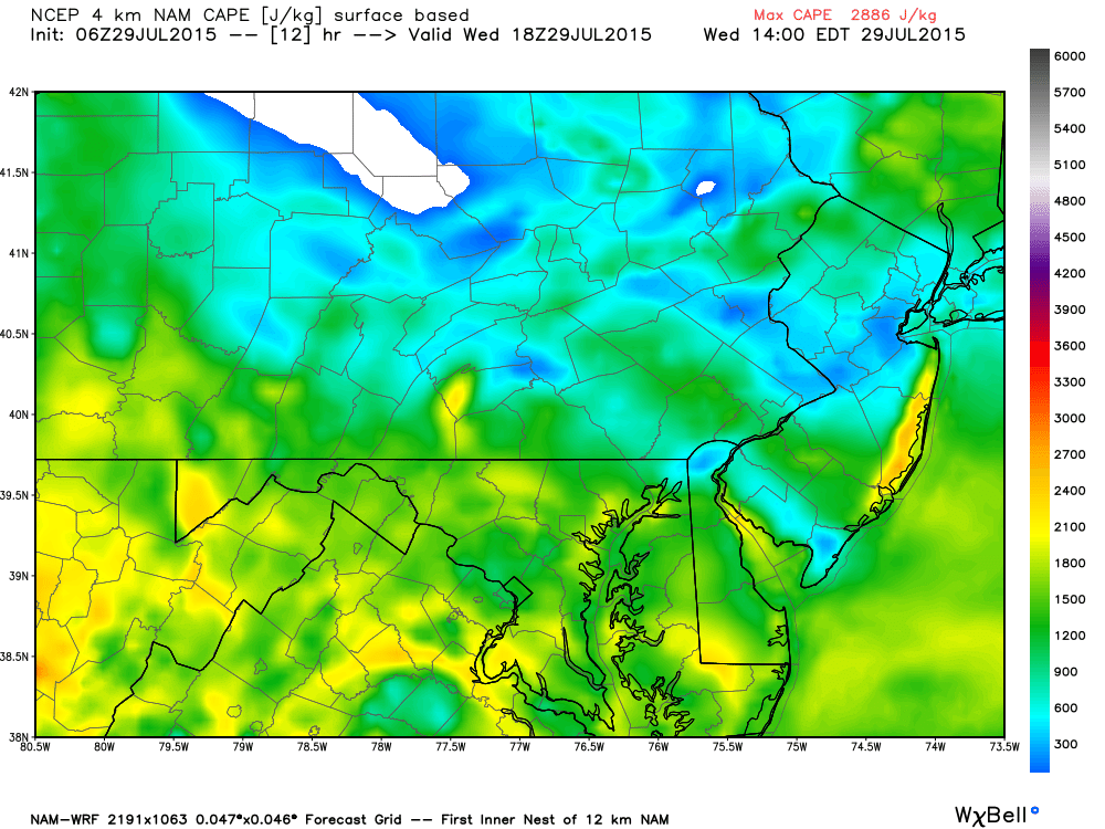
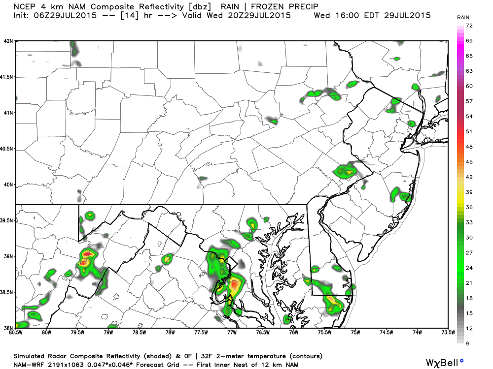
See that higher region along the coast? If a sea breeze front can back in off the ocean with enough force, it could provide the trigger needed for thunderstorm formation. With that said, I think the Jersey Shore has the best potential for storms. The rest of the region will be fighting that capping inversion which traditionally means very isolated pop-up thunderstorms. Here’s the expected precipitation shown on a 850mb map. As you can see, just a few small pop-up cells in the afternoon hours today:
In English: Expect a hazy, hot and humid day with temperatures approaching/breaking 90 in many locations. Heat indices should heavily flirt with 100, especially interior urban locations (Philly-Trenton). Watch out for an isolated shower or thunderstorm towards afternoon-evening hours (very hit-or-miss). I still think a sea breeze front could provide enough of a trigger to spark storms along the coast but we’ll see. Most will miss out with such a localized storm threat. I’ll be watching the radar for 1) That sea breeze front and 2) Any showers or storms that form. Stay hydrated, cool and be safe! JC
Jonathan Carr (JC) is the founder and sole operator of Weather NJ, New Jersey’s largest independent weather reporting agency. Since 2010, Jonathan has provided weather safety and forecasting services for New Jersey and immediate surrounding areas through the web, social media, and app spaces. Originally branded as Severe NJ Weather (before 2014), Weather NJ is proud to bring you accurate and responsible discussions ahead of high-stakes weather scenarios that impact the garden state. All Weather. All New Jersey.™


LOCAL FORECAST | INTERACTIVE RADAR | LATEST NJ WEATHER ALERTS | WEDDING FORECAST| PRIVACY POLICY
© Copyright 2024 Weather NJ LLC. All Rights Reserved.
Some information that can be found on our website is provided by a private weather station and is not an officially recognized station for weather reporting. Though we always strive to achieve accurate reporting for our own use, it is important that you do NOT depend on the data provided here for any purpose.
