

June 22: Rain and T-Storms Expected Thursday
Low pressure will track from the lower Great Lakes through Delmarva on Thursday. It should bring a decent amount of rainfall and possibly embedded thunderstorms to New Jersey for at least the first half (possibly 2/3) of Thursday. Here is some simulated radar reflectivity (for Thursday afternoon) off the latest high-resolution NAM model:
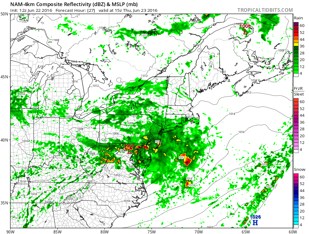
The upper-level steering currents (at 250mb) will be guiding the low pressure center as they are aligned from the Great Lakes through the Mid-Atlantic US. The rainfall is fairly confident. How much embedded thunderstorm activity occurs within is still yet TBD. There will be very little instability however a decent amount of shear. The low itself could act as a trigger. Therefore, this is shaping up to be anything from just widespread rainfall and wind to widespread heavy rainfall with isolated-to-scattered pockets of damaging winds. Either way, it looks like a washout for all of Thursday morning and some of the afternoon. Once the low moves through and the front is out to sea, a beautiful weekend awaits.

In English: Widespread rainfall, possibly heavy at times, along with embedded thunderstorms of strong-to-severe nature are possible on Thursday. Rainfall should be statewide with a more for SNJ (up to 2.5″) than NNJ (up to .5″). SNJ is also favored for embedded thunderstorm activity over NNJ. Timing looks like early Thursday AM hours through late Thursday afternoon. Thursday night into and through the weekend looks magical. Be safe! JC
Jonathan Carr (JC) is the founder and sole operator of Weather NJ, New Jersey’s largest independent weather reporting agency. Since 2010, Jonathan has provided weather safety and forecasting services for New Jersey and immediate surrounding areas through the web, social media, and app spaces. Originally branded as Severe NJ Weather (before 2014), Weather NJ is proud to bring you accurate and responsible discussions ahead of high-stakes weather scenarios that impact the garden state. All Weather. All New Jersey.™


LOCAL FORECAST | INTERACTIVE RADAR | LATEST NJ WEATHER ALERTS | WEDDING FORECAST| PRIVACY POLICY
© Copyright 2024 Weather NJ LLC. All Rights Reserved.
Some information that can be found on our website is provided by a private weather station and is not an officially recognized station for weather reporting. Though we always strive to achieve accurate reporting for our own use, it is important that you do NOT depend on the data provided here for any purpose.
