

June 8: Thunderstorms Approaching!
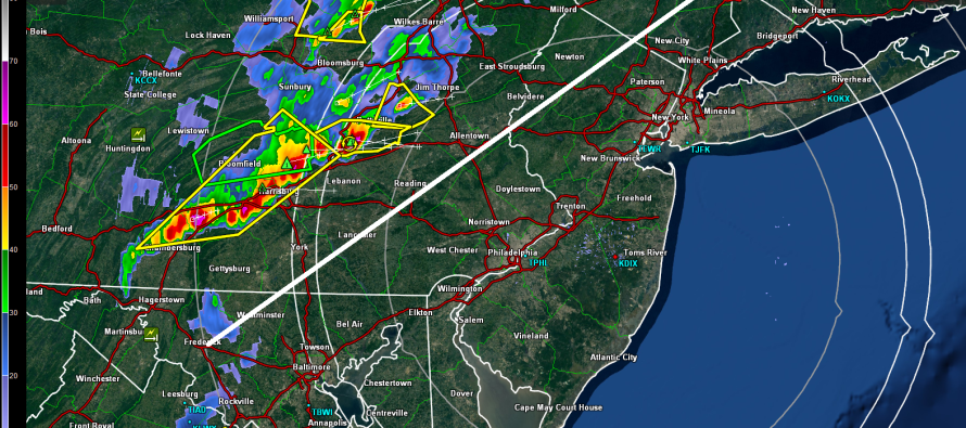
Rain and severe-warned thunderstorms are pushing through parts of Pennsylvania. Conditions are ripe for damaging winds and possibly tornadoes for areas well to the NW of I-95. The only part of New Jersey that could possibly be subject to such is NWNJ. The rest of New Jersey could still see rain and less gustier winds but thunderstorm energy should fizzle as everything pushes to the coast.
The white line I’ve drawn represents where I think the more severe conditions will exist now through overnight. NW of that line should expect severe thunderstorms, hail, and possibly isolated tornadoes over the next 3-6 hours. SE of that line should expect at least gusty rain to push through overnight with a few scattered and embedded strong thunderstorms still possible. Until the rain moves into your area, expect strong wind gusts generally out of the SW. The immediate SENJ coast should expect little to nothing at all. Be safe! JC
Jonathan Carr (JC) is the founder and sole operator of Weather NJ, New Jersey’s largest independent weather reporting agency. Since 2010, Jonathan has provided weather safety and forecasting services for New Jersey and immediate surrounding areas through the web, social media, and app spaces. Originally branded as Severe NJ Weather (before 2014), Weather NJ is proud to bring you accurate and responsible discussions ahead of high-stakes weather scenarios that impact the garden state. All Weather. All New Jersey.™


LOCAL FORECAST | INTERACTIVE RADAR | LATEST NJ WEATHER ALERTS | WEDDING FORECAST| PRIVACY POLICY
© Copyright 2024 Weather NJ LLC. All Rights Reserved.
Some information that can be found on our website is provided by a private weather station and is not an officially recognized station for weather reporting. Though we always strive to achieve accurate reporting for our own use, it is important that you do NOT depend on the data provided here for any purpose.
