

Long Range Outlook – Through April 2016

It’s time to harness the WeatherTrends360 proprietary weather algorithms to see how the rest of April 2016 should play out. But first lets break New Jersey into proper climatological regions. We have the higher elevations of NNJ/NWNJ, the interior coastal plain (SWNJ through CNJ and into NENJ), and the coastal regions (most of SENJ). I’ll be representing each climatological region with a 28-day graph from weathertrends360 data followed by a brief discussion. Please keep in mind that these algorithms are documented with an 84% verification rate and are based on oceanic water cycles and time table series. Do not focus on specific detailed daily forecasts (sun vs clouds, etc). Focus on general trends (cool vs warm, rainy vs dry, etc). That’s what WeatherTrends360 does best.
Higher Elevations of NNJ/NWNJ
(Sussex, Warren, Hunterdon, Morris, N. Somerset, and N. Passaic) – Known for little to no Atlantic Ocean influence, colder-snowier winters, and drier conditions in general when compared to the coast. This region is known to get hot when high pressure sits overhead during the summer and bitterly cold during Arctic outbreaks in the winter.
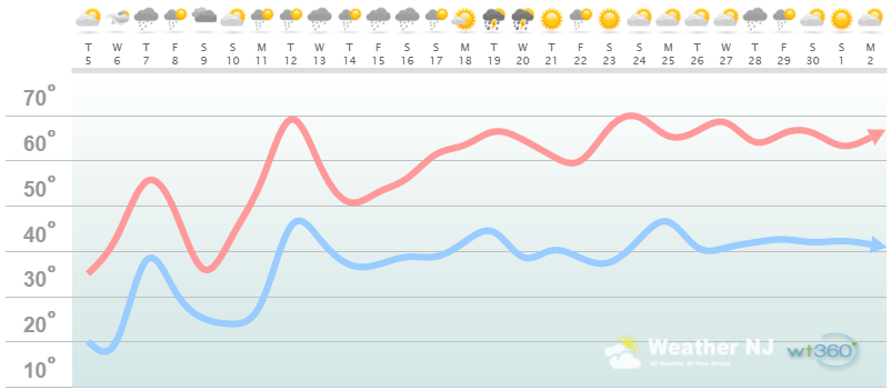
Higher Elevation Discussion: The graph represents the wild temperature swings for the first half of April well IMO. The last noticeable cold snap should occur around next weekend (April 8-11). After that, it’s all uphill with a minor regression (nothing like this upcoming weekend) around ~April 14. With that said, the second half of April looks to feature sustainable warmth in this region with daytime high temperatures of 60+ and ~40 (give or take a few degrees) for overnight low temperatures. As you can also see, there will be no shortage of rain for the first 2/3 of April. The last third of April is setting up for stellar Spring conditions.
Interior Coastal Plain from SWNJ-CNJ-NENJ
(Salem, Gloucester, Camden, W. Burlington, Mercer, W. Monmouth, Middlesex, S. Somerset, Union, Essex, Hudson, Bergen, and S. Passaic) – Known for naturally higher temperatures due to lower elevations away from the oceanic influence. This region is also known as “heat island” due to transportation (I-95 corridor), smog, abundant asphalt, concrete, and other man-made substances that naturally absorb and retain heat moreso than natural protected land.
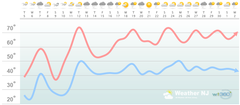
Interior Coastal Plain Discussion: The graph represents the wild temperature swings for the first half of April well IMO. The last noticeable cold snap should occur around next weekend (April 8-11). After that, it’s all uphill with a minor regression (nothing like this upcoming weekend) around ~April 14. With that said, the second half of April looks to feature sustainable warmth in this region with daytime high temperatures of 65-73 and overnight lows in the mid-40s. As you can also see, there will be no shortage of rain for the first 2/3 of April. The last third of April is setting up for stellar Spring conditions.
Coastal Regions of SENJ
(Cumberland, Cape May, Atlantic, E. Burlington, Ocean, and E. Monmouth) – Known for tremendous influence from the Atlantic Ocean. Oceanic influence keeps this zone cooler in the summer and warmer in the winter than the interior coastal plain and especially the higher elevations of NWNJ. This forms a micro-climate that only local inhabitants and frequent visitors are familiar with.
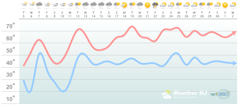
Coastal Region Discussion: The graph represents the wild temperature swings for the first half of April well IMO. The last noticeable cold snap should occur around next weekend (April 8-11). After that, it’s all uphill with a minor regression (nothing like this upcoming weekend) around ~April 14. With that said, the second half of April looks to feature sustainable warmth in this region with daytime high temperatures in the upper-60s/lower-70s and overnight lows in the mid-40s. As you can also see, there will be no shortage of rain for the first 2/3 of April. The last third of April is setting up for stellar Spring conditions.

In English: The general theme for April is pretty similar statewide. We moderate heading into this weekend but experience another, hopefully final, cold snap during the weekend. Snowfall is possible for some areas this weekend from a developing coastal storm. I’m currently monitoring such and will report on it soon. We should then moderate again next week and likely give the cold weather a final boot come ~April 15/16. The second half of April looks much more settled and mild than the first half. We’re almost there! Thunderstorm activity needs to be monitored within 3-4 days of the event. When that happens, I’ll be on it. Otherwise, have a great month and be safe! JC
Weathertrends360 is a complete, global, web solution to help retailers and suppliers capitalize on the weather and its influence on sales and marketing plans up to a year ahead. Learn how to become PROACTIVE vs REACTIVE with the weather in every phase of your business – how much inventory to buy/produce, where to allocate more/less, when to run weather-optimized advertising/marketing campaigns – weathertrends360 can help you determine all of this in minutes! 84% independently audited accuracy for both short-term and year-ahead forecasts for temperature and precipitation.
A forecast Weather Trends issued one year ago is more accurate than every other weather company’s 5 to 14-day forecasts. The University of Miami and West Point PhD Climatologist’s prove WTI’s year-ahead forecasts are several times more accurate than NOAA – Click to Download Report. Also check out their free txt and email alerts!
Jonathan Carr (JC) is the founder and sole operator of Weather NJ, New Jersey’s largest independent weather reporting agency. Since 2010, Jonathan has provided weather safety and forecasting services for New Jersey and immediate surrounding areas through the web, social media, and app spaces. Originally branded as Severe NJ Weather (before 2014), Weather NJ is proud to bring you accurate and responsible discussions ahead of high-stakes weather scenarios that impact the garden state. All Weather. All New Jersey.™


LOCAL FORECAST | INTERACTIVE RADAR | LATEST NJ WEATHER ALERTS | WEDDING FORECAST| PRIVACY POLICY
© Copyright 2024 Weather NJ LLC. All Rights Reserved.
Some information that can be found on our website is provided by a private weather station and is not an officially recognized station for weather reporting. Though we always strive to achieve accurate reporting for our own use, it is important that you do NOT depend on the data provided here for any purpose.
