

Mar 2: Friday Snow Update
A wintry event is likely late Thursday night into Friday. Model guidance has trended more aggressive with the intensity of the low as well as how far the precipitation shield extends northward. I’m fairly confident in at least light snow reaching all the way into NNJ. The lower 2/3 of New Jersey should see the best snowfall rates however the surface temperature profile is looking marginal. I will be monitoring this event closely for any further colder and/or snowier trends on model guidance.
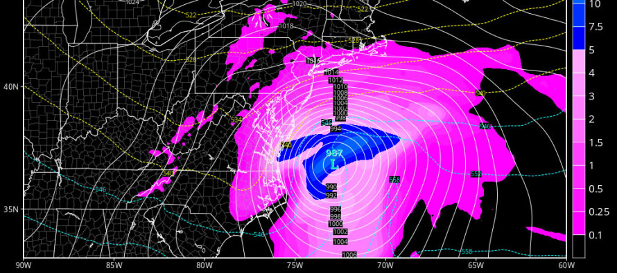
The upper levels appear somewhat favorable for this event. I see a closed off low at 500mb ejecting into the Atlantic Ocean over OBX with at least a neutral trough axis looking to go negative as it swings into the Atlantic. This should create a surface environment favorable for rapid low intensification. The latest guidance has about a 1001mb surface low ejecting over NC and dropping below 990mb just south of the benchmark (40N/-70W). If we truly have a 985mb low south of the benchmark, the precipitation shield must not be underestimated, especially when it slams into the high pressure influence just to the north.
We have a negative AO and NAO which are both modeled to turn positive right after this event (a storm signal in itself). That means we have just enough cold air available and a weak blocking signature. The cold air is straight-forward. The blocking signature is validated by a slightly slower moving system with the inability to turn northward and cut towards the Great Lakes. The PNA is very positive which indicates a healthy W. US ridge. This should ripple downstream in the form of E. US trough amplification.
As far as timing goes, I could see light precipitation breaking out before midnight tomorrow night, possibly as early as 9PM. It should then gradually pick up in intensity through the early AM hours of Friday and taper off by Friday afternoon. Timing is a huge importance here due to the higher March sun angle. Therefore, any snow that falls during overnight hours should have a decent chance of sticking. Once the sun is slightly above the horizon, it will begin warming the surface fast. Also, at that point the low should be throwing onshore flow onto New Jersey from the E/NE (39 degree ocean air mass). I therefore expect at least a small part of SENJ to change over to a mix or even all rain post-sunrise. By that point however a decent amount of snow could be on the ground statewide with AM rush hour disruption already done.
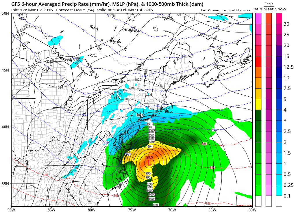
Here’s the latest GFS showing precipitation, temperature and pressure at 850mb between 7AM and 1PM. Friday morning:
In English: Let’s break the state into 3 regions:
NNJ (N of I-78): Light snowfall is possible between 9PM tomorrow night and late-Friday morning. You should stay favorable for accumulation throughout the entire event. I’d say 4 inches worst case scenario for this region with 1-3 inches a more reasonable expectation.
CNJ (S of I-78/N of a line drawn from PHL<->Toms River): Light to moderate snowfall is possible between 9PM tomorrow night and Fiday afternoon. It will be cold enough in the air for snow but the surface should be marginal. Therefore treated roads should be okay but untreated roads could see a few inches of snow. Natural surfaces (grass/trees/etc.) could see higher amounts. The overall theme: more snow will fall than will stick. Overnight snow will accumulate better than once the sun is up. I’d say 3-6 inches of snow would be the worst case scenario for this region with 1-3 inches a more reasonable expectation.
SNJ (S of a line drawn from PHL<->Toms River): Light to moderate snowfall is possible between 9PM tomorrow night and sunrise on Friday. Again, the overall theme: more snow will fall than will stick. After sunrise, a changeover to a mix or even all rain is possible (especially for SENJ coast) before possibly ending as back-end snow Friday afternoon. This area will have the most marginal (warmest) surface temperatures and therefore should see less accumulations than points N. I would say a few slushy inches are possible overnight, moreso on natural surfaces than paved surfaces. I’d say 2-3 inches would be the worst case scenario pre-sunrise with a coating to an inch or two a more reasonable expectation when all is said and done. Roads should mostly just be wet once the sun is above the horizon with the E/NE winds cranking.
Friday morning rush hour could be disruptive. I’ll be watching closely for any further colder/snowier trends. There is a small wildcard chance that this ends up surprising on the colder/snowier side however climatology usually wins 9 times out of 10 this time of year. I’ll put a video out later tonight and issue a snow map early tomorrow evening before precipitation starts. This is how it looks for now though and the warmth is still coming next week! Be safe! JC
Jonathan Carr (JC) is the founder and sole operator of Weather NJ, New Jersey’s largest independent weather reporting agency. Since 2010, Jonathan has provided weather safety and forecasting services for New Jersey and immediate surrounding areas through the web, social media, and app spaces. Originally branded as Severe NJ Weather (before 2014), Weather NJ is proud to bring you accurate and responsible discussions ahead of high-stakes weather scenarios that impact the garden state. All Weather. All New Jersey.™


LOCAL FORECAST | INTERACTIVE RADAR | LATEST NJ WEATHER ALERTS | WEDDING FORECAST| PRIVACY POLICY
© Copyright 2024 Weather NJ LLC. All Rights Reserved.
Some information that can be found on our website is provided by a private weather station and is not an officially recognized station for weather reporting. Though we always strive to achieve accurate reporting for our own use, it is important that you do NOT depend on the data provided here for any purpose.
