

Mar 30: Decent Rainfall Approaching

Decent rainfall is expected between late tonight and late Friday night. Let’s break it down…
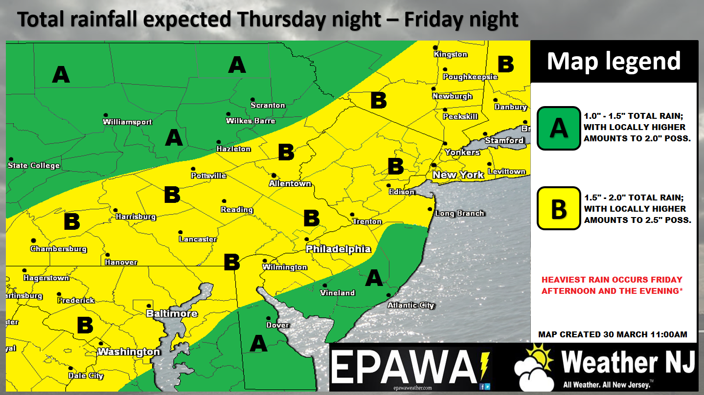
Please click here for full-resolution rain impact map.
Disco: A low pressure system will track from the plains through the Ohio Valley and likely right over New Jersey. This track is obviously too warm for New Jersey snow. Most of NJ should be placed in warm sector flow (winds out of the S) for much of the system. Once the low reaches the coast and ejects into the ocean, winds will return to the N but precipitation should fall apart quickly. There are some wintry concerns for New England (to the N of the low) but again, not for New Jersey.
Our concerns mostly come in the form of flooding. Flash flooding is possible statewide but only under the heaviest bands of rain (will have to be now-casted). Minor coastal flooding is possible along the ocean. Tidal guidance doesn’t look that bad however water levels could rise just enough for rainfall to have nowhere to drain. Places like Long Beach Island, and other barrier islands, are familiar with this. It’s run-of-mill stuff but it could present a nuisance. Tidal levels could be more of a concern for the N Jersey coast (Monmouth County and back into the Raritan Bay). Winds shouldn’t be too much a problem. A 999mb low is generally weak sauce so maybe some wind gusts reach into the 25-35 mph territory with sustained winds of 15-20mph. Let’s allow a small chance of embedded thunderstorms within this overall system. Such could/would produce isolated instances of heavier winds but would likely fall below severe criteria. Something else to watch for during now-casting.
In English: Clouds should continue to increase tonight but rainfall should hold off until after midnight for most of New Jersey. Friday then looks like a statewide washout with breezy conditions and possibly embedded thunderstorms. The heaviest period of rain looks like Friday afternoon into early Friday evening. NNJ should see a colder rain than SNJ. If some sleet or a few snowflakes mix in for extreme NNJ then so be it but no accumulations are expected and I’m just not really feeling it. Conditions should improve Friday night into early Saturday morning allowing for a dry and beautiful spring weekend. It might not be run-to-the beach weather but dry and sunny should feel pretty good. I’ll have the detailed weekend outlook posted later this evening. Be safe! JC
Jonathan Carr (JC) is the founder and sole operator of Weather NJ, New Jersey’s largest independent weather reporting agency. Since 2010, Jonathan has provided weather safety and forecasting services for New Jersey and immediate surrounding areas through the web, social media, and app spaces. Originally branded as Severe NJ Weather (before 2014), Weather NJ is proud to bring you accurate and responsible discussions ahead of high-stakes weather scenarios that impact the garden state. All Weather. All New Jersey.™


LOCAL FORECAST | INTERACTIVE RADAR | LATEST NJ WEATHER ALERTS | WEDDING FORECAST| PRIVACY POLICY
© Copyright 2024 Weather NJ LLC. All Rights Reserved.
Some information that can be found on our website is provided by a private weather station and is not an officially recognized station for weather reporting. Though we always strive to achieve accurate reporting for our own use, it is important that you do NOT depend on the data provided here for any purpose.
