

March 1: System Two Approaches
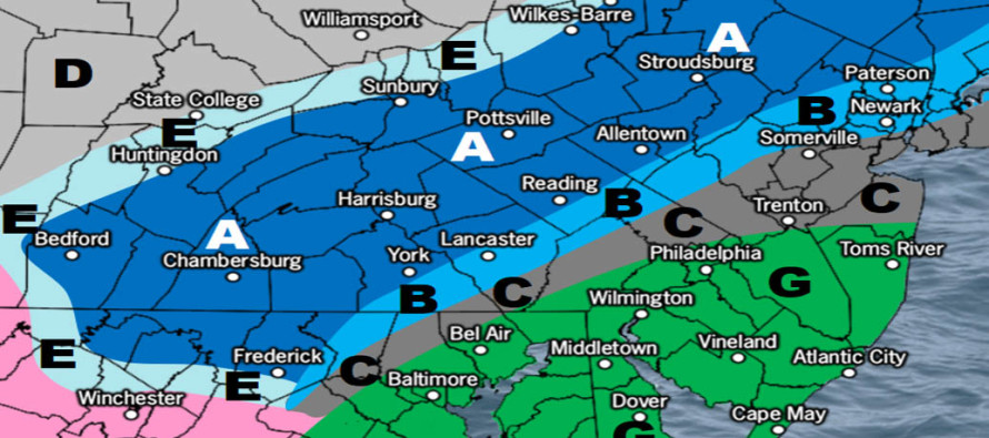
Click here for full-resolution snow map!
Discussion: A weak upper-level jet and unfavorable environment remains at 500mb for tonight’s system. A low however will form and eject off N OBX and pass to the SE of NJ overnight. The onshore flow ahead of the low passage should push temperatures above freezing all the way up to the NJTP/I-95 line through NJ. This is commons sense with above-freezing SE and E marine flow involved. I’m expecting NWNJ to hang onto the colder air and squeeze out light-to-significant accumulations (zone A + B on the snow map above). Zone C could go either way (like B or like G depending on how far the warm air noses into the coast and that is the wildcard potential for a snowy over-performance. Zone G should be all rain regardless but could see some snow mixed in with rain especially closer to the C zone border (which is mostly the I-95 area through Philadelphia and then eastward across I-195 towards the ENJ coast).
Last night’s system #1 was a reminder that cold air can be quite stubborn this time of year especially with the annual-bottom of sea surface temperatures. This next system tonight was always modeled the warmest of all three. The coldest/snowiest outcome would be zone C ending uo like zone B. The most significant aspect about tonight’s system is how it will impact the approaching 3rd system Sunday night into Monday morning. If tonight’s system wraps up as a stronger low in the ocean then it will do two things. 1) It will lower the geopotential heights behind it. This is, for lack of a better term, the highway that the 3rd system will want to take through the Mid-Atlantic US. 2) It will allow more of a tropospheric polar vortex injection meaning a colder outcome overall for system #3. This would come at the price of a quicker-moving progressive impact. Basically if NWNJ sees the jackpot then we’re talking about dusting off the K-word for them. If CNJ/SNJ get in on the jackpot then we would likely max out in the 6-12 range. This is still incredibly uncertain but we’ll have an initial snow map out at 5pm today. For right now the focus is on system #2 tonight.
In English: Wave #2 is approaching NJ and will drop snow and rain between this evening and tomorrow morning. Precipitation should begin as early as sundown this evening for SWNJ an eventually spread through NENJ by midnight. Everything should wrap up tomorrow morning from W to E (closer to dawn for WNJ and closer to 10am for ENJ). The above snow map represents our expected snow accumulations. The wildcard is zone C that could end up like B or G depending on how far NW the line of freezing is shoved in by the developing storm. We then turn all eyes to the Sunday PM-Monday snow system which is looking significant for at least those NW of the NJTP/I-95 line possibly further SE. We’ll have a snow map out for that later today. Download the new free Weather NJ mobile app on Apple and/or Android. It’s the easiest way to never miss Weather NJ content. Our premium services go even further above and beyond at the hyperlocal level. Have a great rest of your Tuesday and please be safe! JC
Jonathan Carr (JC) is the founder and sole operator of Weather NJ, New Jersey’s largest independent weather reporting agency. Since 2010, Jonathan has provided weather safety and forecasting services for New Jersey and immediate surrounding areas through the web, social media, and app spaces. Originally branded as Severe NJ Weather (before 2014), Weather NJ is proud to bring you accurate and responsible discussions ahead of high-stakes weather scenarios that impact the garden state. All Weather. All New Jersey.™


LOCAL FORECAST | INTERACTIVE RADAR | LATEST NJ WEATHER ALERTS | WEDDING FORECAST| PRIVACY POLICY
© Copyright 2024 Weather NJ LLC. All Rights Reserved.
Some information that can be found on our website is provided by a private weather station and is not an officially recognized station for weather reporting. Though we always strive to achieve accurate reporting for our own use, it is important that you do NOT depend on the data provided here for any purpose.
