

March 11: Winter Storm Expected
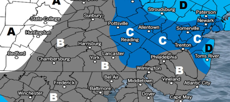
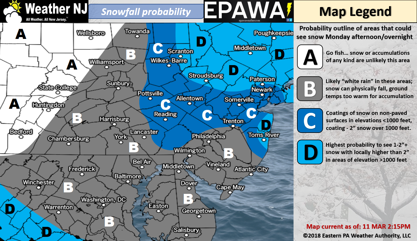
Please click here for full-resolution snow map!
Discussion: Today is a relatively mild nice sunny day and with good reason. The sun angle is rapidly increasing and the clock adjustment even further brings it home. I want this idea to set the stage for this event because climatology and sun angle work strongly against accumulating snow this time of year. You could argue that this upcoming event is expected to drop most precipitation at night which takes the sun angle out of the equation. However, even at the coldest point of Monday night-Tuesday AM, most of NJ is still expected to be above-freezing at the surface.
The storm system is now looking even stronger on model guidance. We’re talking about possibly a sub-970mb getting close to the 40N/70W benchmark. We have a sufficient upstream spike in the jet stream over the W US (+PNA). We have an upper-level low near the Great Lakes that should capture the southern-stream shortwave and produce a negatively-tiled trough. We have all the ingredients on the table for a major east coast snow storm. The thing is… it’s looking that way for New England, not the N Mid-Atlantic. Why? Because the upper-level energy does not phase in time. The negative axis is noteworthy for New England concerns but overall just a bit to far E to bring the major storm scenario to New Jersey.
What’s looking more likely are fringe impacts from the powerful coastal storm that will be out there. I think NYC and the New Jersey areas that surround such (Bergen down and around through Monmouth/Ocean Counties) are most favored for accumulations. I think areas W and S of that are likely looking at a conversational event rather than disruptive (aside from elevations of 1000 feet or greater). I’m still going back and forth on our map above. I feel like it’s either going to be dead-on or possibly a little low for those NYC-surrounding NJ counties. The absolute worst case scenario would be a wildcard surprise of 3-6 inches. The best dynamics will be offshore with the low. We would need to snow very hard late-Monday night into early Tuesday morning to achieve this. It’s possible but less likely. We still have another day to fine tune for the final call. My gut feel is that SWNJ is least favored for accumulations.
Winds should behave similar for most away from the ocean. Sustained winds of 10-20mph with gusts to 30mph are possible for such. Areas right along the coast could see slightly higher values, maybe 15-25mph sustained with gusts to 40mph. Marine tidal guidance indicates that minor coastal flooding is likely the extent with a few isolated areas flirting with the moderate stage. If the center of this storm were to end up closer to the coast then we would see greater coastal impacts. It won’t though.
In English: The above snow map represents our initial thoughts. I know it’s hard to call this a winter storm but flakes will be flying and wind will be blowing. Our map is conservative because of seasonal climatology and proximity of the storm center from shore. We can fine tune tomorrow but the best dynamics are favoring New England over New Jersey for a major winter storm. New Jersey is looking at a light-to-significant event at best for the counties that surround NYC. We’ll bump those area totals tomorrow if necessary but right now the map is what you should at least expect. Moderate winds and more minor coastal flooding/beach erosion are likely. Timing appears to be from Monday afternoon through mid-to-late Tuesday morning. There’s a small possibility SNJ briefly starts as rain Monday PM before changing over to snow. Peak snowfall would occur between late Monday night and early Tuesday morning. Have a great rest of your Sunday and please be safe! JC
For comprehensive and interactive hyper-local analysis that goes way above and beyond the detail of this public forecast, check out our premium services which include early hyper-local text notifications and guaranteed individual forum interaction. A must for outdoor businesses that depend on the best real-time data possible.
Jonathan Carr (JC) is the founder and sole operator of Weather NJ, New Jersey’s largest independent weather reporting agency. Since 2010, Jonathan has provided weather safety and forecasting services for New Jersey and immediate surrounding areas through the web, social media, and app spaces. Originally branded as Severe NJ Weather (before 2014), Weather NJ is proud to bring you accurate and responsible discussions ahead of high-stakes weather scenarios that impact the garden state. All Weather. All New Jersey.™


LOCAL FORECAST | INTERACTIVE RADAR | LATEST NJ WEATHER ALERTS | WEDDING FORECAST| PRIVACY POLICY
© Copyright 2024 Weather NJ LLC. All Rights Reserved.
Some information that can be found on our website is provided by a private weather station and is not an officially recognized station for weather reporting. Though we always strive to achieve accurate reporting for our own use, it is important that you do NOT depend on the data provided here for any purpose.
