

March 15: East Coast Winter Storm Signal Growing
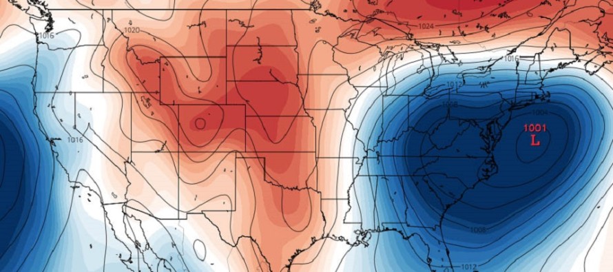
Discussion: Given the active pattern we’re in, I’m gaining confidence in an east coast winter storm next ~Tuesday-Wednesday. My argument is not because of the modeled surface snow maps flying around. About the only guidance worth reasonably considering from this range are ensemble spreads. The above image represents GEFS surface pressure anomalies. Right now they are still not tightly clustered enough for surface speculation IMO. Regardless, most ensemble members do show some type of impact int hat time frame from multiple Pacific energies eventually meeting up with Arctic energy. The upstream energy components are all now visible on satellite imagery. It’s just a matter of how they interact for specific east coast impact.
Too much interaction too quick and we have a low passing over or to the N of New Jersey which would obviously mean a rain storm for most. Not enough interaction and/or cold suppression and we have a weak low passing to our S which would mean light-to-moderate snowfall over SNJ only—and that’s if the precipitation can make it that far N. Split the difference and you have your classic snow/rain line setting up somewhere between I-80 and I-95.
We’re also a bit far out yet for exact timing re: daytime vs overnight precipitation. We know the Tuesday-Wednesday period is the general signal but when exactly the precipitation falls could have tremendous impact on accumulation ability. Peak daytime snowfall and even the NNJ elevations would struggle to accumulate on paved surfaces. Overnight snowfall and even SNJ could still accumulate. Timing could trend 6-12 hours in either direction between now and then. My point is that we are still too far away to forecast precipitation types and amounts. We should be aware of the spread of possibilities however, most of which suggest more gusty winds, snow and/or rain for New Jersey.
Serious storm tracking will likely begin Saturday. Until then I’ll be watching for the ensemble spreads to cluster more tightly, ignoring how wide the surface output sprays back and forth.
In English: Another east coast storm capable of producing more gusty winds, rain and/or snow is gaining confidence for next Tuesday-Wednesday. I’ll be in closely monitoring mode through tomorrow (Friday) night. If the signal is still looking good I’ll then move into serious tracking mode from Saturday-forward. A first call snow map, including expected precipitation types and accumulation amounts, would likely not come until Sunday at the earliest. For now, it’s not time to panic. It’s time to simply be aware of the potential in the time-frame. Have a great night and please be safe! JC
For comprehensive and interactive analysis, including run-by-run model analysis, that goes way above and beyond the detail of this public forecast, check out our premium services which include early hyper-local text notifications and guaranteed individual forum interaction. A must for outdoor businesses or most extreme passionate weather enthusiasts who depend on the best real-time data possible.
GEFS model image credit: Tropical Tidbits
Jonathan Carr (JC) is the founder and sole operator of Weather NJ, New Jersey’s largest independent weather reporting agency. Since 2010, Jonathan has provided weather safety and forecasting services for New Jersey and immediate surrounding areas through the web, social media, and app spaces. Originally branded as Severe NJ Weather (before 2014), Weather NJ is proud to bring you accurate and responsible discussions ahead of high-stakes weather scenarios that impact the garden state. All Weather. All New Jersey.™


LOCAL FORECAST | INTERACTIVE RADAR | LATEST NJ WEATHER ALERTS | WEDDING FORECAST| PRIVACY POLICY
© Copyright 2024 Weather NJ LLC. All Rights Reserved.
Some information that can be found on our website is provided by a private weather station and is not an officially recognized station for weather reporting. Though we always strive to achieve accurate reporting for our own use, it is important that you do NOT depend on the data provided here for any purpose.
