

March 21: Afternoon Winter Storm Update
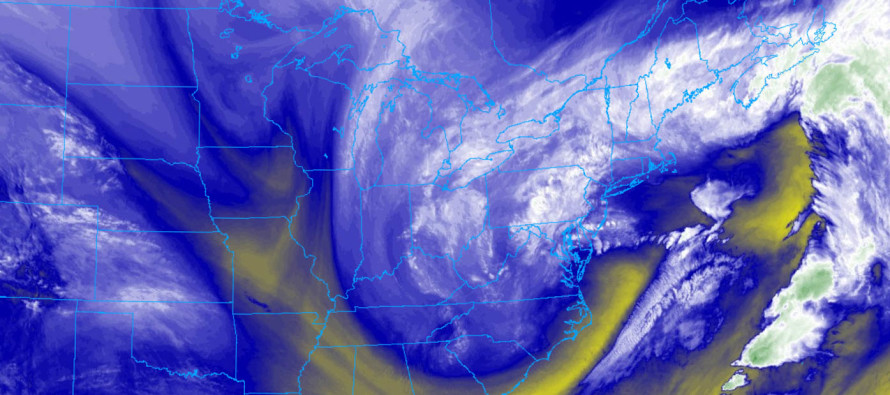
Discussion: Most of New Jersey has changed over to all snow now. So far, most snowfall has occurred during the warmest part of the day with the highest sun angle. This is why much of what has fallen has not stuck yet in many areas. I’m also getting numerous reports of 5-6 inches of snow already in areas like Marlton and Millville where heavier precipitation rates have occurred. There are some double-digit accumulations already in SEPA and all that energy still has to move across New Jersey. Regardless, we’re now entering the peak time window of this event. From now until midnight (give or take an hour), all snow is expected and should be moderate-to-heavy at times. As sun angle declines, temperatures will drop even further and enhance surface snow accumulation. We have a long night ahead. I’d say New Jersey is in the second inning of this ballgame.
The primary coastal surface low is just about finished with the transfer. I see a 994mb low that’s getting its act together about 200 miles SE of Atlantic City. The approaching upper-level low should hold the coastal low in place for the next 3-6 hours before the upper-level and surface lows unite and pull away together. This period represents the best potential for convective heavy snowfall via mesoscale banding under the greatest areas of frontogenesis. I still think many areas will verify our general expectations with a handful of the usual surprise suspects that happen with any major event. It’s far too soon to judge however. Let this play out until about midnight before looking back at the forecast verification/performance. I understand this is a little late to get going but it also looks a little late to end.
Winds have pretty much peaked as far as onshore flow goes. They should sustain along the coast and maybe increase a bit more inland. Wind direction should slowly rock from N/NE to N to NW over the next 12 hours or so. Once the system pulls away to the E tomorrow morning, we should be left with gusty back-side NW cyclonic flow. Therefore from now through tomorrow expect heavy wet snow to cause power issues. Those branches and power lines can only support so much weight before giving.
Coastal flooding expectations remain in the minor-to-moderate risk category. The SENJ coast (Cape May and Atlantic) is at a slightly higher risk than the NE Jersey coast (Monmouth and Ocean) The next high tide is closer to midnight tonight which should be the highest level yet. Tidal stages should begin returning to normal after tomorrow’s high tide near noon.
In English: Most of NJ is now under snowfall. Periods of moderate-to-heavy snowfall are expected between now and ~midnight tonight. This should wrap up from W to E so maybe by 10PM for PHL and 2AM for the ENJ coast. Now that the sun is on its way down, surface accumulations should take hold more easily due to dropping surface temperatures. Later start for the thumping? Yes but it looks like a later finish as well early tomorrow morning. Some very heavy bands of snow should develop across New Jersey this evening. Let’s let this system play out tonight and overnight before judging it prematurely. Winds and coastal flooding performing about as expected. The bottom line for safety: Travel conditions are about to rapidly deteriorate for the PM rush hour so please be safe! JC
For year-round comprehensive and interactive analysis, including run-by-run model storm analysis, that goes way above and beyond the detail of this public forecast, check out our premium services which include early hyper-local text notifications and guaranteed individual forum interaction. A must for outdoor businesses or the most extreme passionate weather enthusiast who depends on the best real-time data possible.
Jonathan Carr (JC) is the founder and sole operator of Weather NJ, New Jersey’s largest independent weather reporting agency. Since 2010, Jonathan has provided weather safety and forecasting services for New Jersey and immediate surrounding areas through the web, social media, and app spaces. Originally branded as Severe NJ Weather (before 2014), Weather NJ is proud to bring you accurate and responsible discussions ahead of high-stakes weather scenarios that impact the garden state. All Weather. All New Jersey.™


LOCAL FORECAST | INTERACTIVE RADAR | LATEST NJ WEATHER ALERTS | WEDDING FORECAST| PRIVACY POLICY
© Copyright 2024 Weather NJ LLC. All Rights Reserved.
Some information that can be found on our website is provided by a private weather station and is not an officially recognized station for weather reporting. Though we always strive to achieve accurate reporting for our own use, it is important that you do NOT depend on the data provided here for any purpose.
