

March 4: Winter Storm Detected
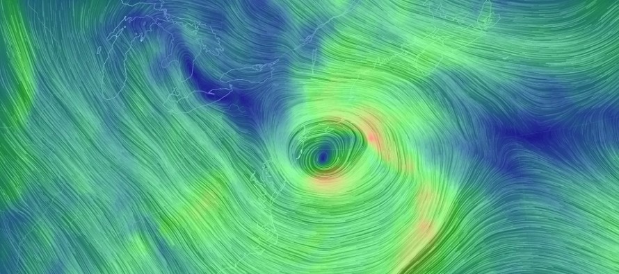
Discussion: The blocking signal is still strong enough to impact approaching upper-level shortwaves coming in from Canada. A few shortwaves are expected to meander in from the W/NW in a “ring around the rosie” manner. Despite the incredible block, the approaching Pacific pattern is not traditional. Either way the most important shortwave is the one that will interact with the surface low and put a ~1000mb storm off the VA/NC coastal border Wednesday morning. This low is then expected to intensify (but not bomb) to between 985-990mb and track towards the 40N/70W benchmark through early Thursday morning.
The latest model guidance suggests a possible close passage to the SENJ Jersey shore. This would mean temperature issues SE of I-95 to start in a rain-to-snow scenario. How quick the changeover occurs would determine the extent of wintry impact. The I-95 corridor and points NW of such would have the best chance to see an all snow solution considering the likely surface temperature profile (NW of the baroclinic boundary). There is still uncertainty however as to what side of I-95 the heaviest snowfall (jackpot) would occur. This will have to be ironed out over the next few days as we closer approach. Our first call map will be issued tomorrow.
This system does not have retrograde potential so it’s hard for me to call it a nor’easter. We should definitely see a period of onshore flow capable of producing at least minor coastal flooding and beach erosion. A coastal winter storm or coastal low is probably the best way to describe this potential IMO.
In English: Another winter storm is likely between late Tuesday night and early Thursday morning with Wednesday likely seeing the meat and potatoes of the storm system. At this point it’s likely that those SE of I-95 (especially coastal SENJ) will experience a rain to snow situation. It’s likely that I-95 and points NW will stay all snow from start to finish (or after minimal initial mixing). It’s likely that the coast will see a period of strong onshore flow capable of producing at least minor coastal flooding. What’s yet to be determined and uncertain are expected snowfall accumulations. Our first call snow map will be out tomorrow at 5PM. For now it’s becoming likely that a plowable snow event could impact many in NJ. Be safe! JC
For comprehensive and interactive hyper-local analysis that goes way above and beyond the detail of this public forecast, check out our premium services which include early hyper-local text notifications from and guaranteed individual forum interaction.
Jonathan Carr (JC) is the founder and sole operator of Weather NJ, New Jersey’s largest independent weather reporting agency. Since 2010, Jonathan has provided weather safety and forecasting services for New Jersey and immediate surrounding areas through the web, social media, and app spaces. Originally branded as Severe NJ Weather (before 2014), Weather NJ is proud to bring you accurate and responsible discussions ahead of high-stakes weather scenarios that impact the garden state. All Weather. All New Jersey.™


LOCAL FORECAST | INTERACTIVE RADAR | LATEST NJ WEATHER ALERTS | WEDDING FORECAST| PRIVACY POLICY
© Copyright 2024 Weather NJ LLC. All Rights Reserved.
Some information that can be found on our website is provided by a private weather station and is not an officially recognized station for weather reporting. Though we always strive to achieve accurate reporting for our own use, it is important that you do NOT depend on the data provided here for any purpose.
