

March 5: Wednesday Snow Map
Click here for full-resolution snow map!
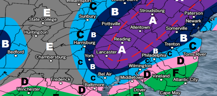
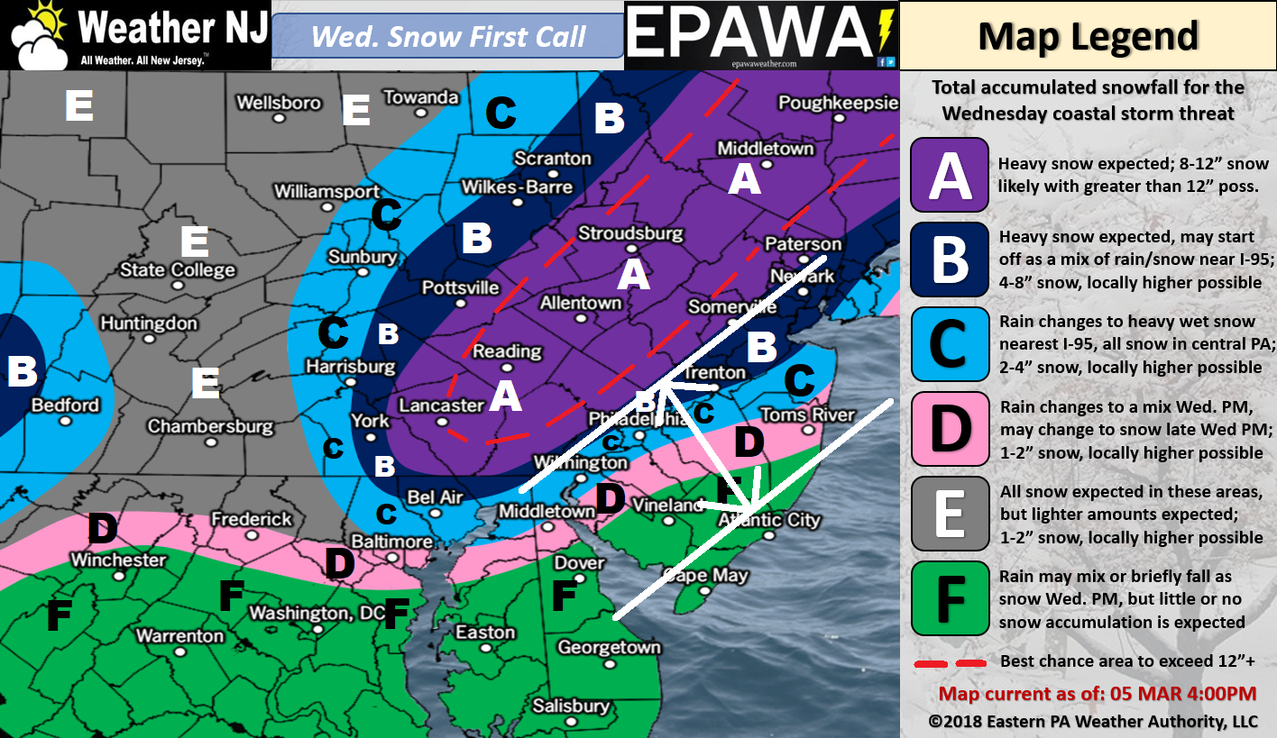
Discussion: I know this map is busy so let me explain. The idea of jackpot accumulations occurring to the NW of I-95 is a fair assumption. That’s your most-likely Kaboom zone (zone A). The idea that extreme SENJ (S Ocean down through AC/Cape May/etc) sees the least possible accumulation is also a fair assumption. The area between however (between the white parallel lines – along and SE of I-95)) is very difficult to call from this point. There are numerous factors including climatology, marine influence, dynamic cooling, surface low track, etc. that could really make this area go either way. Personally, my gut feeling is that this area will result a little snowier than this map indicates, especially closer to I-95. This would mean higher accumulations for Philadelphia and NYC than are indicated by this map.
This map was made at 2pm today and already recent guidance has since shifted totals a little higher along and just SE of I-95. Tomorrow at 5pm will be our final call and we therefore have room to tweak based on what we observe overnight tonight and tomorrow leading up to tomorrow afternoon. So that there is no confusion, this is a first and conservative call…what we believe you will at least see.
The upper-level energy from this system is still expected to track across the N US generally from the northern plains to Delmarva, while interacting with Canadian energy along the way, and ultimately turning up the coast towards Cape Cod. The surface low is expected to do the same but take a closer track to the NJ coast which creates the rain-to-snow situation for many. There is still some disagreement on how close the surface low tracks to the coast which feeds a big part of the uncertainty represented in the white area above. Also ocean temperatures are still pretty cold which impacts the extent of the snow/rain line.
By tomorrow’s final call at 5PM I think we’ll have a much better consensus for this area as well as all other areas. Otherwise NNJ and possibly parts of CNJ are most favored for a Kaboom with SNJ not off the hook from a plowable event (less extreme SENJ). The wind component should not be as bad as the latest nor’easter. Wind direction should rock from SE to NW as the low passes by. I can see wind gusts exceeding 40mph at times, especially along the coast.
In English: Another winter storm has become imminent. The timing is from late-Tuesday PM through early-Thursday AM with the meat and potatoes occurring from early-Wednesday AM through late Wednesday-PM. The above map is very conservative and only our first call. The final call will be out at 5pm tomorrow and will feature any necessary adjustments. I can already tell you that we will probably have to bump-up the area between the white parallel lines based on guidance/obs just made after the generation of the map graphic. 8-12+ for the jackpot area is likely conservative as well. For this first map we wanted to go with what you should “at least” see. You should expect gusty winds during this system, especially along the coast, but not as bad as the recent nor’easter. Coastal flooding should be held to just a minor risk given the lower than normal astronomical tides. Definitely going to rip along the beach though. Have a great night and please be safe! JC
For comprehensive and interactive hyper-local analysis that goes way above and beyond the detail of this public forecast, check out our premium services which include early hyper-local text notifications from and guaranteed individual forum interaction.
Jonathan Carr (JC) is the founder and sole operator of Weather NJ, New Jersey’s largest independent weather reporting agency. Since 2010, Jonathan has provided weather safety and forecasting services for New Jersey and immediate surrounding areas through the web, social media, and app spaces. Originally branded as Severe NJ Weather (before 2014), Weather NJ is proud to bring you accurate and responsible discussions ahead of high-stakes weather scenarios that impact the garden state. All Weather. All New Jersey.™


LOCAL FORECAST | INTERACTIVE RADAR | LATEST NJ WEATHER ALERTS | WEDDING FORECAST| PRIVACY POLICY
© Copyright 2024 Weather NJ LLC. All Rights Reserved.
Some information that can be found on our website is provided by a private weather station and is not an officially recognized station for weather reporting. Though we always strive to achieve accurate reporting for our own use, it is important that you do NOT depend on the data provided here for any purpose.
