

May 2017 Discussion

It’s time to harness the WeatherTrends360 proprietary weather algorithms to see how the rest of May 017 should play out. But first lets break New Jersey into proper climatological regions. We have the higher elevations of NNJ/NWNJ, the interior coastal plain (SWNJ through CNJ and into NENJ), and the coastal regions (most of SENJ). I’ll be representing each climatological region with a 28-day graph from weathertrends360 data followed by a brief discussion.
Please keep in mind that these algorithms are documented with an 84% verification rate and are based on oceanic water cycles, time table series and very complex mathematics. The best takeaway from this data are general trends (cool vs warm, rainy vs dry, etc). I’m always hesitant to forecast specific surface conditions (rainfall amounts, snowfall amounts, winds, etc) beyond the 4-7 day forecasting period. But temperature and precipitation trends is what WeatherTrends360 does best with their proprietary mathematical analysis derived from over 150 years of reactive pattern data. For this reason, let’s call this a long-range discussion of expectations rather than a locked-in forecast.
Higher Elevations of NNJ/NWNJ
(Sussex, Warren, Hunterdon, Morris, N. Somerset, and N. Passaic) – Known for little to no Atlantic Ocean influence, colder-snowier winters, and drier conditions in general when compared to the coast. This rnown to get hot when high pressure sits overhead during the summer and bitterly cold during Arctic outbreaks in the winter. Elevation is a major influence that separates this micro-climate from the rest of New Jersey. This region extends into NE PA (Poconos) and parts of NY State (Catskills).
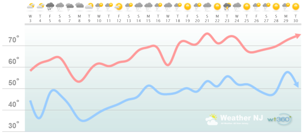
Higher Elevation Discussion: A cooler first-half, possibly first 2/3, of May jumps out at me for this region followed by a warmer finish. By ~May 18 this region should be recovering towards warmer temperatures. As of right now the Memorial Day Weekend should be on the warmer side but that will really depend on wind direction. Warmer if winds are out of the W<->S and cooler if winds are out of the NW-E. Some will think the next few weeks are cold while others will enjoy the spring days that many claim to no longer exist between winter and summer. Overnight frosts are possible through May 11, especially in the May 8 to May 10 period which should be our coldest period this month. Precipitation looks plentiful throughout the entire month which is good news for water reserves and aquifers.
Interior Coastal Plain from SWNJ-CNJ-NENJ
(Salem, Gloucester, Camden, W. Burlington, Mercer, W. Monmouth, Middlesex, S. Somerset, Union, Essex, Hudson, Bergen, and S. Passaic) – Known for naturally higher temperatures due to lower elevations away from the oceanic influence. This region is also known as “heat island” due to transportation (I-95 corridor), smog, abundant asphalt, concrete, and other man-made substances that naturally absorb and retain heat moreso than natural protected land. This is why excessive heat warnings and air quality alerts are more common in this region. SWNJ always tends to run a few degrees warmer than NENJ but this region is very similar otherwise in micro-climate due to the parallel nature of the Appalachian Mountain elevations to the NW. The same micro-climate can be extended into SE PA and NE MD which tends to run just a little stormier than NJ. This however is what makes up the interior coastal plain.
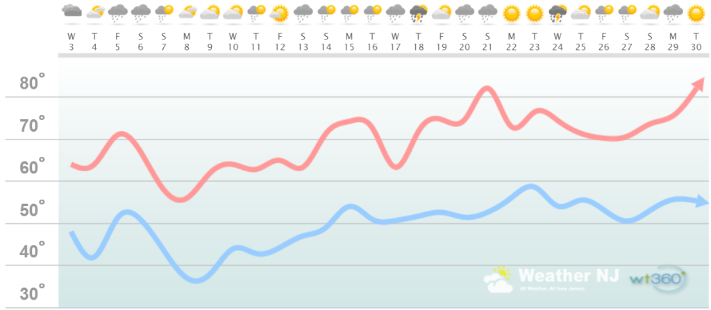
Interior Coastal Plain Discussion: A cooler first-half of May jumps out at me for this region followed by a warmer finish. By ~May 13 this region should see sustained temperatures of 70 or above for afternoon highs. As of right now the Memorial Day Weekend should be on the warmer side but that will really depend on wind direction. Warmer if winds are out of the W<->S and cooler if winds are out of the NW-E. Some will think the next few weeks are cold while others will enjoy the spring days that many claim to no longer exist between winter and summer. Overnight frosts are possible through about May 10, especially in the May 7 to May 9 period which should be this region’s coldest period this month. Precipitation looks plentiful throughout the entire month which is good news for water reserves and aquifers.
Coastal Regions of SENJ
(Cumberland, Cape May, Atlantic, E. Burlington, Ocean, and E. Monmouth) – Known for tremendous influence from the Atlantic Ocean. Oceanic influence keeps this zone cooler in the summer and warmer in the winter than the interior coastal plain and especially the higher elevations of NWNJ. In the summer, sea breeze fronts back into the coast and can ignite thunderstorms if enough instability is present. The cooler marine air slides under the hot air to the W and provides additional atmospheric lifting. This is both why it’s 5-15 degrees cooler at the shore than the Philly-Trenton area and why near-stationary thunderstorms can form along the coast capable of producing localized flash flooding. In the winter, the ocean is warmer than interior regions which plays a huge role in rain vs. snow—highly dependent on wind direction. When the winds chance from NE to N/NE, that’s usually when temps crash and change rain over to snow. Regardless, this micro-climate is well known, well documented and well expressed. This region extends into most of Delaware as well.
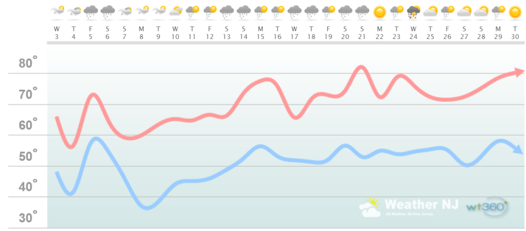
Coastal Region Discussion: A cooler first-half, possibly first 2/3, of May jumps out at me for this region followed by a warmer finish. By ~May 18 this region should be recovering towards warmer temperatures. As of right now the Memorial Day Weekend should be on the warmer side but that will really depend on wind direction. Warmer if winds are out of the W<->S and cooler if winds are out of the NW-E. We all know what onshore flow can do for Memorial Day Weekend with ocean temperatures still in the 50s. 70s and sun can go to 5os and fog very quickly. I’ll be monitoring this more closely for coastal regions as impacts of such are highest here. Some will think the next few weeks are cold while others will enjoy the spring days that many claim to no longer exist between winter and summer. Overnight frosts are possible through May 11, especially in the May 8 to May 10 period which should be our coldest period this month. Precipitation looks plentiful throughout the entire month which is good news for water reserves and aquifers although this region has seen less drought than points N/NW in New Jersey.

Weathertrends360 is a complete, global, web solution to help retailers and suppliers capitalize on the weather and its influence on sales and marketing plans up to a year ahead. Learn how to become PROACTIVE vs REACTIVE with the weather in every phase of your business – how much inventory to buy/produce, where to allocate more/less, when to run weather-optimized advertising/marketing campaigns – weathertrends360 can help you determine all of this in minutes! 84% independently audited accuracy for both short-term and year-ahead forecasts for temperature and precipitation.
Discussion: The reason for the colder start/first half/2/3 of May is because of a slow-moving and stubborn upper-level trough. This trough will feature an upper-level low at its heart and will crawl through the E US for much of early May. We can thank a strong blocking signal over Greenland (-NAO) for producing the cut-off upper-level lows and longwave troughs that will bring the cooler weather. This will keep the lower atmosphere very condensed with cold air not too far aloft. Therefore daytime diurnal heating could lead to quicker destabilization than if heights were higher with a warmer upper-level setup. For this reason, the entire period (first-half to first 2/3 of May) appears unsettled. Given the meridional look to the jet stream all the way upstream and across the Pacific Ocean towards Asia, I anticipate an active May. This means lots of rain and thunderstorms between 2-3 day periods of sun. But for now…a prolonged cool start to May with a warm finish along with sufficient moisture to sustain a non-drought status.
In English: Overall, the month of May should start cool and end warm. The distribution of temperature appears to favor cooler temperatures from today through ~May 18 with warmer temperatures from ~May 18-forward. I see sufficient rain to battle drought status with plenty of sunny days between storm systems. Given how active May looks, I suspect frequent thunderstorm environments. All the run-of-mill stuff that comes with May in New Jersey appears likely, but perhaps with amplified storm activity. We’ll take each 4-7 day forecasting period at a time. Everyone have a great month and please be safe! JC
Jonathan Carr (JC) is the founder and sole operator of Weather NJ, New Jersey’s largest independent weather reporting agency. Since 2010, Jonathan has provided weather safety and forecasting services for New Jersey and immediate surrounding areas through the web, social media, and app spaces. Originally branded as Severe NJ Weather (before 2014), Weather NJ is proud to bring you accurate and responsible discussions ahead of high-stakes weather scenarios that impact the garden state. All Weather. All New Jersey.™


LOCAL FORECAST | INTERACTIVE RADAR | LATEST NJ WEATHER ALERTS | WEDDING FORECAST| PRIVACY POLICY
© Copyright 2024 Weather NJ LLC. All Rights Reserved.
Some information that can be found on our website is provided by a private weather station and is not an officially recognized station for weather reporting. Though we always strive to achieve accurate reporting for our own use, it is important that you do NOT depend on the data provided here for any purpose.
