

May 27: Watching Thunderstorm Potential Today

It looks like New Jersey is in for another warm and humid day away from the ocean. This presents a favorable environment for thunderstorm development as atmospheric instability couples with high dew points for cumulonimbus cloud fuel. The overall setup lacks high wind shear parameters which means we’re more likely to see pulsing rain/thunderstorm cells rather than widespread linear high wind gusts. In a decent instability low wind shear environment, the cumulus clouds build, dump, and choke themselves out on rain columns. Energy then transfers laterally and repeats. This is evident on radar by cells pulsing and jumping over time and that’s what I think will happen this afternoon/evening. Pulsing thunderstorms can display great natural fireworks so frequent lightning is definitely a possibility. Let’s look at some supporting guidance:
Instability at the surface this afternoon:
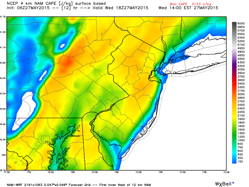
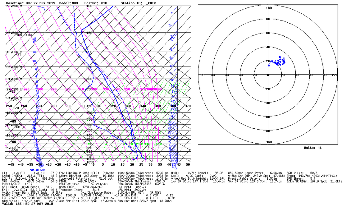
Away from the coast there is no shortage of surface-based instability. Most of New Jersey is modeled to see over 2000j/kg (joules per kilogram) of SBCAPE (Surface Based Convective Available Potential Energy). This will likely be the result of diurnal solar surface heating. Cloud debris inhibits surface instability while clear skies enhance. A better indication of atmospheric instability exists in the higher levels which is better measured by MLCAPE (Mixed Layer Convective Available Potential Energy). As the following thermodynamic sounding diagram for the KDIX (Mount Holly, NJ) station indicates, MLCAPE is about 1300j/kg which is a decent amount. Whenever MLCAPE is greater than 1000j/kg, a good light show is generally favorable. Also notice the -4.4 LI (Lifted Index) and weak wind shear profile. The best shear will exist far to our NW:
In English: Expect warm and humid conditions with S/SW winds for most of the day, especially away from the ocean. The coast will be cooler as ocean surface temperatures are still hovering around 60F. As we heat up through the afternoon, thunderstorms with heavy downpours and frequent lightning are possible through the evening. I wouldn’t expect much of anything prior to afternoon hours. The atmospheric setup favors widespread downpours and frequent lightning but isolated severe criteria could be met for wind gusts and/or hail. I’ll head out chasing with a livestream if it gets good enough. Remember, thunderstorms are hit or miss so not everyone will see them. Also, 9 times out of 10, they fizzle out before making it to the coast. While all of NJ is game for possible showers and thunderstorms today, I think everyone NW of the turnpike has a better chance. Be safe! JC
Jonathan Carr (JC) is the founder and sole operator of Weather NJ, New Jersey’s largest independent weather reporting agency. Since 2010, Jonathan has provided weather safety and forecasting services for New Jersey and immediate surrounding areas through the web, social media, and app spaces. Originally branded as Severe NJ Weather (before 2014), Weather NJ is proud to bring you accurate and responsible discussions ahead of high-stakes weather scenarios that impact the garden state. All Weather. All New Jersey.™


LOCAL FORECAST | INTERACTIVE RADAR | LATEST NJ WEATHER ALERTS | WEDDING FORECAST| PRIVACY POLICY
© Copyright 2024 Weather NJ LLC. All Rights Reserved.
Some information that can be found on our website is provided by a private weather station and is not an officially recognized station for weather reporting. Though we always strive to achieve accurate reporting for our own use, it is important that you do NOT depend on the data provided here for any purpose.
