

May 4: Rainstorm Approaching

Rainfall, possibly heavy at times, is approaching. Here’s what to expect…
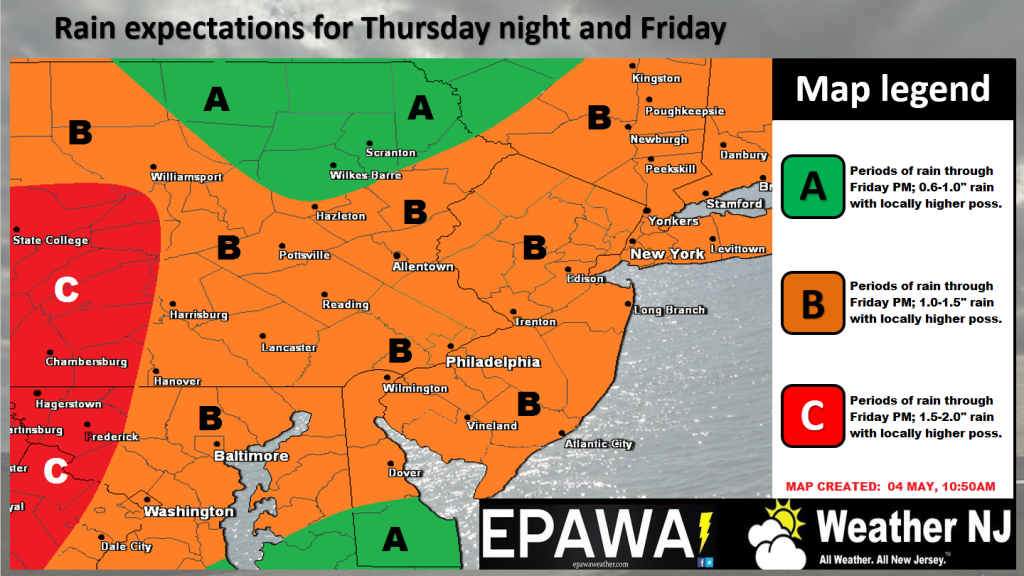
Discussion: I don’t expect much to happen this evening or even tonight other than some initial scattered rainfall and slight increase in SE winds. Definitely an increase in cloud coverage though. Rainfall should then pick up after midnight and peak in intensity between sunrise and early afternoon hours tomorrow. Here’s our expected totals which includes initial rain tonight and heavy rain tomorrow:
Click here for full resolution rain impact map!
1 to 1.5 inches of rainfall, in general, are modeled to fall across New Jersey from now through Friday evening. I’d lean towards NNJ seeing a little more than SNJ at this time. The heavier rain should shut off by Friday afternoon despite the above model going out through 7PM. Some areas could see higher amounts locally under the heaviest bands of precipitation. During peak rainstorm conditions (let’s call it 7am to 1pm tomorrow), embedded thunderstorms are possible as well as flash flooding in low-lying areas of poor drainage. We might hear about some tornadic activity to our SW in the VA/NC area but that should stay to the SW of NJ. If that threat pushes further NW closer to NJ, I’ll post as soon as I see it. But for now, stay calm about it. Winds direction should be off the ocean for most of this event (out of ~SE). Areas away from the ocean will see lesser winds compared to the coast. More rainfall is then possible this weekend but should be of an isolated-to-scattered nature rather than widespread like tomorrow’s (Friday’s) expectations. As far as temperatures go, most rainfall should occur in the warm sector of the passing low to our W (the low should track over W PA and into NY State). Therefore, temperatures could hold off on dropping until later Saturday into Sunday, bottoming out early next week. I’ll touch more on this in the weekend outlook which I’ll release tomorrow morning.
In English: Light rain and onshore (SE) breeze could start anytime this evening. Rainfall and winds should then pick up by 7AM tomorrow morning and last through at least early afternoon hours. 1-2 inches of rain are possible along with minor-to-moderate onshore winds (gusts of 25-35mph along coast…lesser away from ocean). Watch out for flash flooding should any rain bands park over areas of poor drainage. Thunderstorms are also possible within the overall system. We’ll have to play exact locations of flooding and thunderstorms by radar. While the heavier rainfall should taper off by tomorrow afternoon, isolated-to-scattered rainfall is possible throughout the weekend. Temperatures should trend cooler between Saturday night and Monday morning to start next week. Everyone have a great rest of your Thursday. May the 4th be with you. Be safe! JC
Jonathan Carr (JC) is the founder and sole operator of Weather NJ, New Jersey’s largest independent weather reporting agency. Since 2010, Jonathan has provided weather safety and forecasting services for New Jersey and immediate surrounding areas through the web, social media, and app spaces. Originally branded as Severe NJ Weather (before 2014), Weather NJ is proud to bring you accurate and responsible discussions ahead of high-stakes weather scenarios that impact the garden state. All Weather. All New Jersey.™


LOCAL FORECAST | INTERACTIVE RADAR | LATEST NJ WEATHER ALERTS | WEDDING FORECAST| PRIVACY POLICY
© Copyright 2024 Weather NJ LLC. All Rights Reserved.
Some information that can be found on our website is provided by a private weather station and is not an officially recognized station for weather reporting. Though we always strive to achieve accurate reporting for our own use, it is important that you do NOT depend on the data provided here for any purpose.
