

May 5: Watching the Tropics
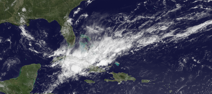
Low pressure, as pictured by NOAA, is organizing over the Greater Antilles. It should form a surface low later today and track towards the SE US between now and early next week. If the surface low meets tropical storm criteria, it will be named Ana. New Jersey impacts should be little to nothing at all. Should a landfall occur in the SE US, it will likely be in the South Carolina area (or just offshore of SC) later this week. It would then drift, while weakening, towards OBX and possibly absorb into a passing cold front sometime next week. All that would do is enhance rainfall along the cold front allowing for widespread rainfall instead of scattered rainfall. I’d use caution along the beaches this weekend regarding rip currents. Otherwise, that’s about all we can expect for New Jersey impacts from the current SE US area being watched. Be safe! JC
Jonathan Carr (JC) is the founder and sole operator of Weather NJ, New Jersey’s largest independent weather reporting agency. Since 2010, Jonathan has provided weather safety and forecasting services for New Jersey and immediate surrounding areas through the web, social media, and app spaces. Originally branded as Severe NJ Weather (before 2014), Weather NJ is proud to bring you accurate and responsible discussions ahead of high-stakes weather scenarios that impact the garden state. All Weather. All New Jersey.™


LOCAL FORECAST | INTERACTIVE RADAR | LATEST NJ WEATHER ALERTS | WEDDING FORECAST| PRIVACY POLICY
© Copyright 2024 Weather NJ LLC. All Rights Reserved.
Some information that can be found on our website is provided by a private weather station and is not an officially recognized station for weather reporting. Though we always strive to achieve accurate reporting for our own use, it is important that you do NOT depend on the data provided here for any purpose.
