

Mixed Conditions Expected (Feb 2-4)
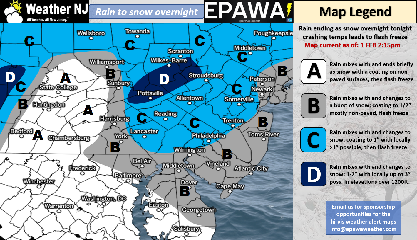
Click here for full resolution snow map!
Discussion: A cold front will push through between now and tomorrow. The front is expected to push through the precipitation shield faster than the precipitation ends. Therefore this should produce a rain to mix to snow situation from NW to SE between tonight and tomorrow morning. Ending snow accumulations are expected to be light but the biggest threat is the rapid freeze for tomorrow morning’s rush-hour commute. All rain that falls (and snow that melts) on roadways will likely freeze so please be careful. Hopefully there are adequate salt treatments planned. I would expect travel delays through late-morning. The above snow map illustrates our expected outcome.
Friday (Feb 2) high temperatures should range from mid-20s to mid-30s NNJ to SNJ. Skies should gradually clear through morning-afternoon hours. Be careful of slippery surfaces produced by the Thursday night-early Friday morning system. Winds should be breezy and occasionally gusty at times out of the NW. Overnight lows should range from single-digits to teens NNJ to SNJ.
Saturday (Feb 3) high temperatures should reach the low-to-mid 30s statewide. Skies should start partly sunny but increase in cloud coverage throughout the day. Winds should be light for most out of the W/SW…a bit breezier out of the W/SW for SNJ. Overnight lows should fall into the 20s statewide.
Sunday (Feb 4) high temperatures should range from mid-30s to mid-40s from NNJ to SNJ. Skies should be mostly cloudy with rain likely beginning by noon. There exists a small chance for initial front end snowfall but that would likely changeover to rain rather quickly. NWNJ stands the best chance to see anything accumulate on non-paved surfaces. It might even be too warm of a system for that though. Precipitation should end between 9pm-midnight. Winds should be light out of the S. Overnight lows should range from mid-20s to mid-30s.
An early look at next week indicates a colder start to the week in the wake of the departing Sunday rain system. Another storm signal exists mid-week however it currently looks too warm for snowfall. Aside from that mid-week signal, the rest of next week looks to feature near-average to slightly-below-average temperatures. The rest of February looks to feature plenty of cold with a very active pattern. I’ll have the February outlook posted tomorrow. We’re only about 2/3 through the snowy season now so I wouldn’t go calling winter over. You wouldn’t call a baseball game after 6 innings, right? In mid-to-late March I’ll sing that song with you. But not just yet. Have a great weekend and please be safe! JC
For comprehensive and interactive hyper-local analysis that goes way above and beyond the detail of this public forecast, check out our premium services which include text notifications and forum access.
Jonathan Carr (JC) is the founder and sole operator of Weather NJ, New Jersey’s largest independent weather reporting agency. Since 2010, Jonathan has provided weather safety and forecasting services for New Jersey and immediate surrounding areas through the web, social media, and app spaces. Originally branded as Severe NJ Weather (before 2014), Weather NJ is proud to bring you accurate and responsible discussions ahead of high-stakes weather scenarios that impact the garden state. All Weather. All New Jersey.™


LOCAL FORECAST | INTERACTIVE RADAR | LATEST NJ WEATHER ALERTS | WEDDING FORECAST| PRIVACY POLICY
© Copyright 2024 Weather NJ LLC. All Rights Reserved.
Some information that can be found on our website is provided by a private weather station and is not an officially recognized station for weather reporting. Though we always strive to achieve accurate reporting for our own use, it is important that you do NOT depend on the data provided here for any purpose.

)