

Monday Night Observations
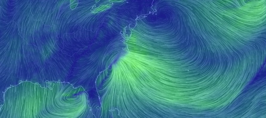
Here’s how the atmosphere looks as precipitation is starting to break out to our SW…
Surface temperatures are at or below freezing for the northern 2/3 of NJ. The lower 1/3 (mostly SENJ) is sitting in the mid-30s. Dew point temperatures however are extremely dry. As the air saturates, dew points will rise and temperatures will fall. They will meet in the middle in what is called a wet bulb temperature. Right now, wet bulb surface temperatures are below freezing for the entire state with the exception of extreme SE Cape May County.
Moving up to the 925mb layer (about 2500 feet up), temperatures are below freezing for the entire state. The 925mb line of freezing is to our S off the Delmarva Peninsula. At 850mb (just under 5000 feet up), temperatures are below freezing for the entire state. The 850mb line of freezing is even further to our S near the Virginia area of the Delmarva Peninsula. At 700mb (just under 10,000 feet up), temperature are below freezing for the entire state. The 700mb line of freezing is near the North Carolina/South Carolina border.
What this tells me are that dynamics can produce colder conditions than you would think for such a tightly-tucked low pressure center. Heavy precipitation (which is expected) could therefore saturate most of New Jersey down to near-freezing at the surface via wet bulb…and also bring colder air down aloft. This happened in March of 1993. We cannot ignore however the strength of warmer onshore flow that will come with such a tucked-in surface low. Therefore, the above layers and temperatures should warm to a point before dropping again. That point will be when the low is closest to the coast tomorrow morning. Once that pulls away then the snow/rain line will reverse and most areas should end as snow with the exception of again, extreme SENJ.
I do think that S Ocean County and back through most of Cumberland County (and all points SE of that line) will see more rain and mixing than snow with this storm but that’s been a main point of discussions all last week and this past weekend. N Ocean County and back through the Delaware Memorial Bridge area however (and all points NW of that) should take the most advantage of everything I said above regarding the colder outcome. For this reason, NW Ocean County should be an entirely different planet than S Ocean County with a steep cut-off. If you are S of exit 74 on the Parkway and/or SE of Route 70, your greatest concern is wind and coastal flooding (coastal flooding along the coast and flash flooding away from the ocean)…not the sloppy light-to-significant accumulations that are expected.
Everyone to the NW of a line drawn from N Ocean County back through the Delaware Memorial Bridge should continue to expect a very disruptive snow storm. This places central Ocean County back through the Salem/Cumberland County border in a very awkward location as they could go either way (heavy snow or more of a mix). The following diagram illustrates all of these these thoughts…
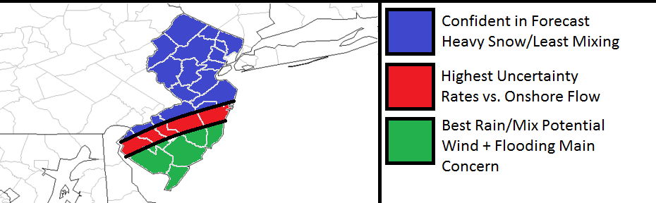
Click here to view in full resolution.
In English: The low might end up tracking a little closer to the coast. This should/could result in a warmer lower-level temperature profile for the green area above…at least in theory. Wet bulb temperatures at the surface and heavy precipitation rates however can help overcome this warmer lower-level scenario (for the red and even some of the NW green areas but that’s a wait and see situation. For that reason, the red area presents the highest uncertainty of the entire forecast for this storm. The red area could easily end up in either the blue or green area of expectations. That’s basically the area we predicted 6-10 inches for so I would lean towards the lower end of that range at this point in time. For the green area, we predicted 6 inches or less with a sharp cut-off to the coast. I would also lean towards the lower range of expectations for the green area. Here’s our snow map one more time for your reference of ranges:

Click here to view in full resolution.
We should have a good idea of which way the red area is going to go by about 4-5AM. For the area in blue, I’m still very confident that “it’s on.” My next update like this will likely come around 9AM tomorrow morning but I will open up a live observation thread later tonight so that user-reports can help paint the picture of how it’s exactly working out. I will likely also post radar updates on my social media sites. Red and green areas should not let their guard down as high winds coastal flooding remain a solid risk regardless of whether they perform in the higher or lower range of expectations. Everyone have a great night and please be safe! JC
Jonathan Carr (JC) is the founder and sole operator of Weather NJ, New Jersey’s largest independent weather reporting agency. Since 2010, Jonathan has provided weather safety and forecasting services for New Jersey and immediate surrounding areas through the web, social media, and app spaces. Originally branded as Severe NJ Weather (before 2014), Weather NJ is proud to bring you accurate and responsible discussions ahead of high-stakes weather scenarios that impact the garden state. All Weather. All New Jersey.™


LOCAL FORECAST | INTERACTIVE RADAR | LATEST NJ WEATHER ALERTS | WEDDING FORECAST| PRIVACY POLICY
© Copyright 2024 Weather NJ LLC. All Rights Reserved.
Some information that can be found on our website is provided by a private weather station and is not an officially recognized station for weather reporting. Though we always strive to achieve accurate reporting for our own use, it is important that you do NOT depend on the data provided here for any purpose.
