

NJ Long Range Outlook – Spring is Just Ahead!

It’s time to harness the true power of WeatherTrend360’s proprietary algorithms again as we begin to close out Winter. First lets break New Jersey into proper climatological regions. We have the upper elevations of NWNJ, the interior coastal plain (SWNJ through CNJ and into NENJ), and the coastal regions (most of SENJ). I’ll be representing each climatological region with a 28-day graph from weathertrends360 data followed by a brief discussion. Keep in mind that these algorithms are documented with an 84% accuracy rate and are based on oceanic water cycles and time table series. It’s not 100% but better than everything else out there.
Zone 1: Higher Elevations of NWNJ (Sussex, Warren, Hunterdon, Morris, N. Somerset, and N. Passaic) – Known for little to no Atlantic Ocean influence, colder-snowier winters, and drier conditions in general when compared to the coast. This region is known to get hot when high pressure sits overhead during the summer and bitterly cold during Arctic outbreaks in the winter.
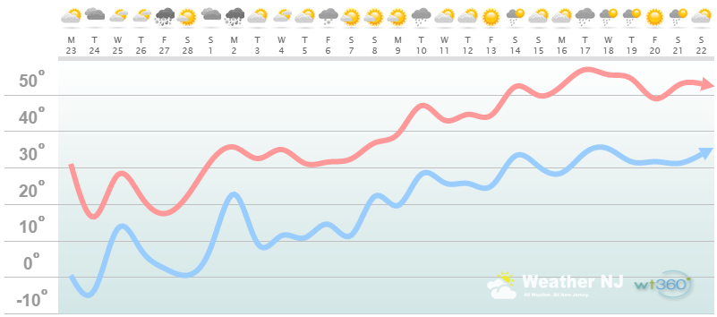
Zone 1 Discussion: The rest of February should be overall colder than average. March 1 seems like a turning point (at least first gear) for warmer temperatures with highs in the 30s. March 9 seems like a shift into second gear as high temperatures reach into the 40s and 50s there afterward. With that being said, this week and weekend might be the last chance for a decent snow storm this winter. Regardless, precipitation looks to be average if not slightly below over the next month or so.
Zone 2: Interior Coastal Plain (Salem, Gloucester, Camden, W. Burlington, Mercer, W. Monmouth, Middlesex, Union, Essex, Hudson, Bergen, and S. Passaic) – Known for naturally higher temperatures due to lower elevations away from the oceanic influence. This region is also known as “heat island” due to transportation (I-95 corridor), smog, abundant asphalt, concrete, and other man-made substances that naturally absorb and retain heat.
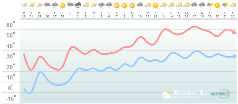
Zone 2 Discussion: The rest of February should be overall colder than average. March 1 seems like a turning point (at least first gear) for warmer temperatures with highs in the 30s and 40s. March 9 seems like a shift into second gear as high temperatures reach into the upper-40s, 50s and even 60s there afterward. With that being said, this week and weekend might be the last chance for a decent snow storm this winter. Regardless, precipitation looks to be average if not slightly below over the next month or so.
Zone 3: Coastal Regions (Cumberland, Cape May, Atlantic, E. Burlington, Ocean, and E. Monmouth) – Known for tremendous influence from the Atlantic Ocean. Oceanic influence keeps this zone cooler in the summer and warmer in the winter than the interior coastal plain and especially the higher elevations of NWNJ. This forms a micro-climate that only local inhabitants and frequent visitors are familiar with.
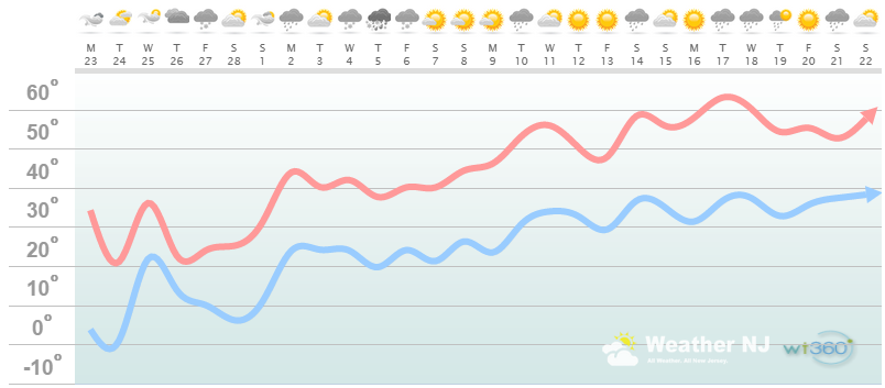
Zone 3 Discussion: The rest of February should be overall colder than average. March 1 seems like a turning point (at least first gear) for warmer temperatures with highs in the 30s and 40s. March 9 seems like a shift into second gear as high temperatures reach into the upper-40s, 50s and even 60s there afterward. With that being said, this week and weekend might be the last chance for a decent snow storm this winter. Regardless, precipitation looks to be average if not slightly below over the next month or so.
In English: The current cold pattern will continue through the rest of February. March 1-9 seems slightly less cold but by March 9-forward, we’re staring Spring in the face with mild temperatures and normal rainfall amounts.
Weathertrends360 is a complete, global, web solution to help retailers and suppliers capitalize on the weather and its influence on sales and marketing plans up to a year ahead. Learn how to become PROACTIVE vs REACTIVE with the weather in every phase of your business – how much inventory to buy/produce, where to allocate more/less, when to run weather-optimized advertising/marketing campaigns – weathertrends360 can help you determine all of this in minutes! 84% independently audited accuracy for both short-term and year-ahead forecasts for temperature and precipitation.
A forecast Weather Trends issued one year ago is more accurate than every other weather company’s 5 to 14-day forecasts. The University of Miami and West Point PhD Climatologist’s prove WTI’s year-ahead forecasts are several times more accurate than NOAA – Click to Download Report.
Enjoy the rest of your February and first 2/3 of March as we close out Winter. Please be safe! JC
Jonathan Carr (JC) is the founder and sole operator of Weather NJ, New Jersey’s largest independent weather reporting agency. Since 2010, Jonathan has provided weather safety and forecasting services for New Jersey and immediate surrounding areas through the web, social media, and app spaces. Originally branded as Severe NJ Weather (before 2014), Weather NJ is proud to bring you accurate and responsible discussions ahead of high-stakes weather scenarios that impact the garden state. All Weather. All New Jersey.™


LOCAL FORECAST | INTERACTIVE RADAR | LATEST NJ WEATHER ALERTS | WEDDING FORECAST| PRIVACY POLICY
© Copyright 2024 Weather NJ LLC. All Rights Reserved.
Some information that can be found on our website is provided by a private weather station and is not an officially recognized station for weather reporting. Though we always strive to achieve accurate reporting for our own use, it is important that you do NOT depend on the data provided here for any purpose.
