

NJ Long Range Outlook – We’re Almost There!

There’s a light at the end of the tunnel after the recent cold we’ve had to endure. For best results lets harness the WeatherTrend360’s proprietary algorithms again as we close out March. First lets break New Jersey into proper climatological regions. We have the upper elevations of NWNJ, the interior coastal plain (SWNJ through CNJ and into NENJ), and the coastal regions (most of SENJ). I’ll be representing each climatological region with a 28-day graph from weathertrends360 data followed by a brief discussion. Keep in mind that these algorithms are documented with an 84% accuracy rate and are based on oceanic water cycles and time table series.
Zone 1: Higher Elevations of NWNJ (Sussex, Warren, Hunterdon, Morris, N. Somerset, and N. Passaic) – Known for little to no Atlantic Ocean influence, colder-snowier winters, and drier conditions in general when compared to the coast. This region is known to get hot when high pressure sits overhead during the summer and bitterly cold during Arctic outbreaks in the winter.
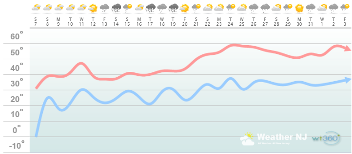
Zone 1 Discussion: Climatology favors this region to hold onto colder temperatures longer than other parts of New Jersey. With that being said, we’re still looking an overall warming trend through the end of March. Today through mid-next week will be a slow climb. Wednesday (March 11) should flirt with 50 degrees for high temperatures, if not more. Then this region is looking at a few periods of precipitation in the March 12-19 time-frame with near average temperatures. The sun angle will be very strong so in order for precipitation to be wintry, it would have to fall during dark hours (which are rapidly shrinking as we approach the equinox). March 20-21 is looking like an even more aggressive moderation with temperatures surging into the 50s and possibly even 60. This region should then close March out with the general temperature profile of highs in the 50s and lows in the 30s.
Zone 2: Interior Coastal Plain (Salem, Gloucester, Camden, W. Burlington, Mercer, W. Monmouth, Middlesex, Union, Essex, Hudson, Bergen, and S. Passaic) – Known for naturally higher temperatures due to lower elevations away from the oceanic influence. This region is also known as “heat island” due to transportation (I-95 corridor), smog, abundant asphalt, concrete, and other man-made substances that naturally absorb and retain heat moreso than natural protected land.
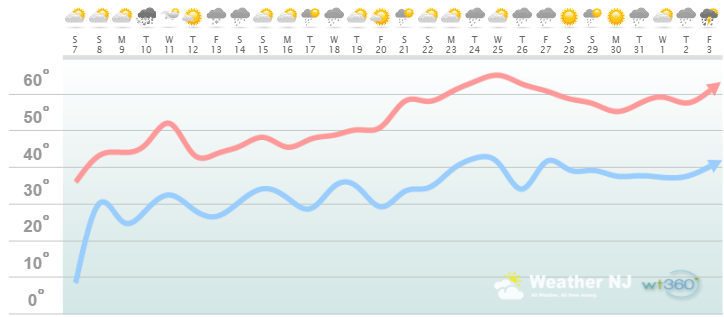
Zone 2 Discussion: Temperatures will moderate today through Wednesday with highs eventually reaching into the 50s mid-week with some light rain. We’re then looking at highs in the 40s during the March 12-19 time-frame which should feature a few periods of precipitation. The sun angle will be very strong so in order for precipitation to be wintry, it would have to fall during dark hours (which are rapidly shrinking as we approach the equinox). March 20-21 is looking like an even more aggressive moderation with temperatures surging into the 50s and 60s. This region should then close March out with the general temperature profile of highs around 60 and lows around 40.
Zone 3: Coastal Regions (Cumberland, Cape May, Atlantic, E. Burlington, Ocean, and E. Monmouth) – Known for tremendous influence from the Atlantic Ocean. Oceanic influence keeps this zone cooler in the summer and warmer in the winter than the interior coastal plain and especially the higher elevations of NWNJ. This forms a micro-climate that only local inhabitants and frequent visitors are familiar with.
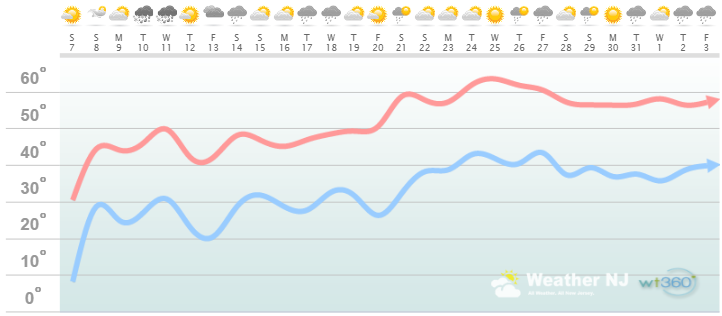
Zone 3 Discussion: This region is buffered by the colder ocean this time of year. Therefore it will be a few degrees colder than zone 2 for highs and lows. Temperatures will moderate today through Wednesday with highs eventually reaching into the 50s mid-week. Some rain could accompany the mid-week warm-up. We’re then looking at highs in the 40s during the March 12-19 time-frame which should feature a few periods of precipitation. The sun angle will be very strong so in order for precipitation to be wintry, it would have to fall during dark hours (which are rapidly shrinking as we approach the equinox). March 20-21 is looking like an even more aggressive moderation with temperatures surging into the 50s and 60s. This region should then close March out with the general temperature profile of highs around 55-60 and lows around 40.
In English: We’re moderating in March, as it naturally does heading into Spring, but it won’t be a straight trend upwards. There should be a few hurdles to get through in that March 12-19 period which may even include a snowy scenario or two, especially for the upper elevations of NWNJ. Again, it would have to time perfectly overnight due to the sun’s higher angle and daytime temps above freezing. The next 5 days, however, and last 10 days of March should feel great after the below-average Arctic temperatures we’ve had to endure. Ironically, the first day of Spring will be well-timed with the invasion of “windows-open weather.” The light is definitely visible at the end of the tunnel.
Weathertrends360 is a complete, global, web solution to help retailers and suppliers capitalize on the weather and its influence on sales and marketing plans up to a year ahead. Learn how to become PROACTIVE vs REACTIVE with the weather in every phase of your business – how much inventory to buy/produce, where to allocate more/less, when to run weather-optimized advertising/marketing campaigns – weathertrends360 can help you determine all of this in minutes! 84% independently audited accuracy for both short-term and year-ahead forecasts for temperature and precipitation.
A forecast Weather Trends issued one year ago is more accurate than every other weather company’s 5 to 14-day forecasts. The University of Miami and West Point PhD Climatologist’s prove WTI’s year-ahead forecasts are several times more accurate than NOAA – Click to Download Report.
Enjoy the rest of your March and please be safe! JC
Jonathan Carr (JC) is the founder and sole operator of Weather NJ, New Jersey’s largest independent weather reporting agency. Since 2010, Jonathan has provided weather safety and forecasting services for New Jersey and immediate surrounding areas through the web, social media, and app spaces. Originally branded as Severe NJ Weather (before 2014), Weather NJ is proud to bring you accurate and responsible discussions ahead of high-stakes weather scenarios that impact the garden state. All Weather. All New Jersey.™


LOCAL FORECAST | INTERACTIVE RADAR | LATEST NJ WEATHER ALERTS | WEDDING FORECAST| PRIVACY POLICY
© Copyright 2024 Weather NJ LLC. All Rights Reserved.
Some information that can be found on our website is provided by a private weather station and is not an officially recognized station for weather reporting. Though we always strive to achieve accurate reporting for our own use, it is important that you do NOT depend on the data provided here for any purpose.
