

Nor’easter Pulls Away (March 3-4)
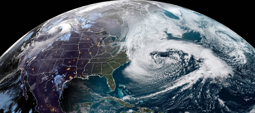
Discussion: The above modern satellite imagery shows the nor’easter pulling away from the E US. A tremendous mid-latitude cyclone! Southern coastal New England took the worst of it. New Jersey only dealt with secondary effects. NNJ elevations Kaboomed with snowfall accumulations exceeding 12 inches in several confirmed reports. Snowfall over-performed for interior NJ, especially in W CNJ and SWNJ where only a rain/snow mix was expected. Instead a few inches of snow was able to stack up on paved-surfaces due to the strong deformation band that formed from the ~Poconos down through ~Philadelphia. Even parts of SENJ ended with a slushy coating on roads. We can thank the low’s intensity for this. Central pressure dropped to about 972mb and forced adiabatic cooling. The deformation band was then strong enough to bring the cold air down to the surface via heavy precipitation. This dropped the surface temperatures via latent heat exchange. Winds also lived up to their warnings but not for everyone. There were widespread reports of gusts exceeding 50mph and in some cases 60mph. Some locations however did not see the heavier winds brought down from the atmosphere. There are still numerous power outages and crews are working hard towards restoration. Coastal flooding looks like it will top out in the moderate stage rather than major stage. This is because the low only retrograded a fraction of expectation and is now taking more of a SE track than S/SE. We’re still going to see a few minor-moderate high tides (the next 3) over the next 24-36 hours but the historic possibility is off the table. And thank goodness!
Aside from the continued coastal flooding risk, the rest of this weekend looks dry and breezy. That should remain the status quo into next week until a mid-week coastal storm puts snow and rain back on the table for Wednesday. Winds and coastal flooding would be much less of an issue than this last nor’easter due to the lack of blocking and allowance for a progressive moving system.
Saturday (Mar 3) high temperatures should reach into the mid-40s for most. NNJ might struggle to break 40 but could eventually get there during peak sun angle. Skies should feature a mixed bag of sun and clouds. Coastal flooding remains a concern with moderate levels still possible surrounding both high tides. Winds should remain gusty out of the N/NW but continue to subside. Overnight lows should fall into the 30s statewide.
Sunday (Mar 4) high temperatures should again reach into the 40s for most. A near-carbon copy of Saturday with partly sunny skies and breezy/gusty winds out of the N/NW. Coastal flooding will still be possible but only minor levels likely. Overnight lows should fall into the 20s statewide.
An early look at next week indicates more of the same through about Tuesday. We’re then looking at another coastal storm for Wednesday which could bring more snow and rain to NJ. That would in-theory set up a colder (not brutal) and drier next weekend. Let’s revisit everything in a few days. Have a great rest of your weekend and please be safe! JC
For comprehensive and interactive hyper-local analysis that goes way above and beyond the detail of this public forecast, check out our premium services which include hyper-local text notifications from and guaranteed forum discussion with myself and Eastern PA Weather Authority (EPAWA).
Jonathan Carr (JC) is the founder and sole operator of Weather NJ, New Jersey’s largest independent weather reporting agency. Since 2010, Jonathan has provided weather safety and forecasting services for New Jersey and immediate surrounding areas through the web, social media, and app spaces. Originally branded as Severe NJ Weather (before 2014), Weather NJ is proud to bring you accurate and responsible discussions ahead of high-stakes weather scenarios that impact the garden state. All Weather. All New Jersey.™


LOCAL FORECAST | INTERACTIVE RADAR | LATEST NJ WEATHER ALERTS | WEDDING FORECAST| PRIVACY POLICY
© Copyright 2024 Weather NJ LLC. All Rights Reserved.
Some information that can be found on our website is provided by a private weather station and is not an officially recognized station for weather reporting. Though we always strive to achieve accurate reporting for our own use, it is important that you do NOT depend on the data provided here for any purpose.

)