

Nov 12: Winter Weather Update
We’re approaching the Arctic outbreak and light snow possibilities that I’ve been discussing in the past few weeks. Remnants of Typhoon Nuri went on to become the strongest Bering Sea storm on record. That energy pushed up into the Alaskan polar regions of the northern hemisphere and in return, plunged arctic air mass southward into the central and eastern US. The frontal boundary of this colder air mass is approaching the east coast and will be through by early tomorrow morning.
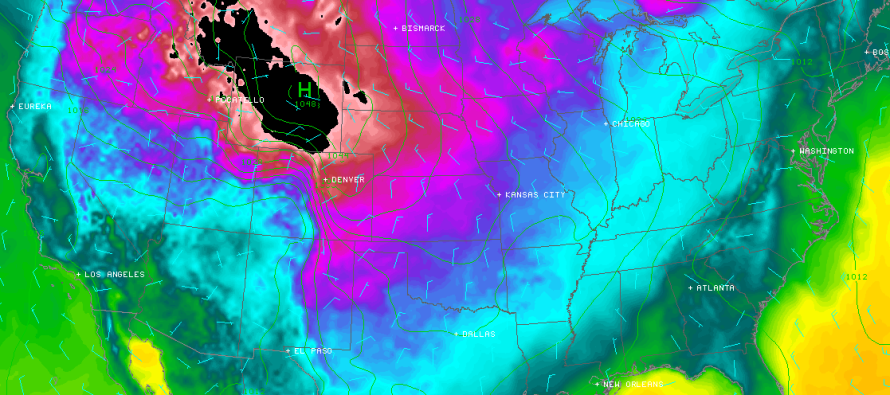
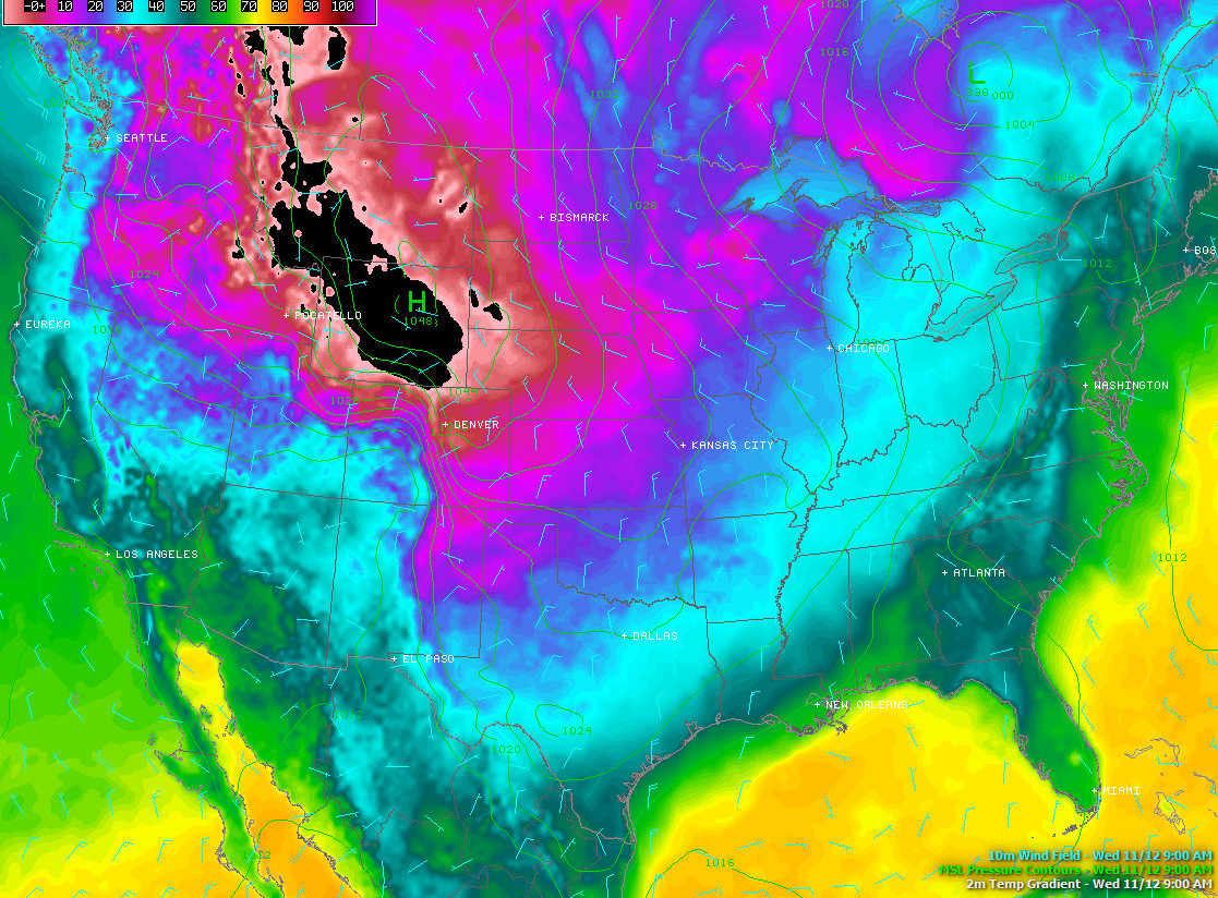
Here on this SimuAwips image, you can see the temperature difference line set up over the Appalachian Mountains and moving east. You can also see the two big synoptic players of this US pattern. The low over eastern Canada spins counter-clockwise while the arctic high over Wyoming (black = below zero) spins clockwise. This has opened the gates to energy that has broken off of the Polar Vortex (not “THE” Polar Vortex). The blue wind indicators also show you wind direction/intensity:
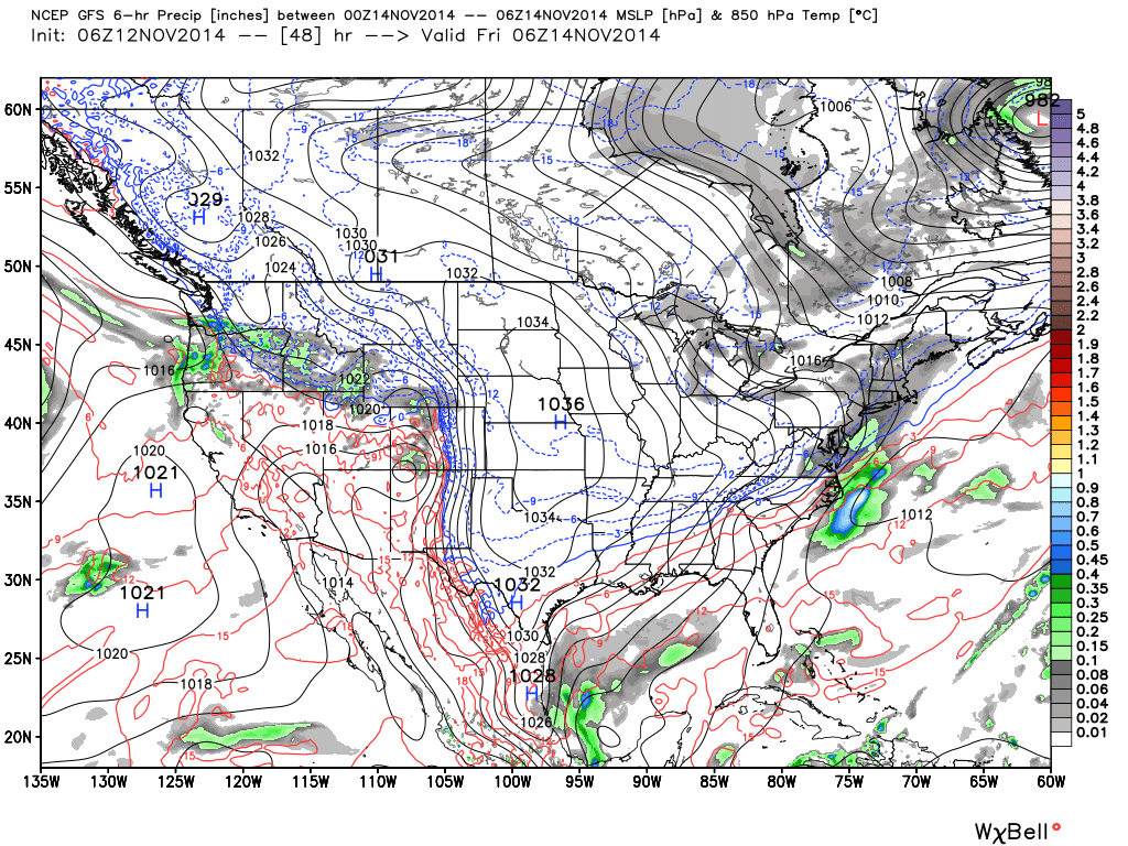
Now lets talk about the first light snow possibility. This is not a big deal…a “nuisance at most” with only trace-minor accumulations expected. Perhaps a few inches in the higher elevations of NWNJ and a coating to the coast on non-paved surfaces. It should start as light rain in the evening and change over to snow by midnight. Don’t be wearing pajamas inside out for a snow day on Friday though…not happening! Festive? sure! Disruptive? No. Here it is on the new upgraded GFS. This map shows 850mb pressure, temperature, and precipitation that has fallen between 7PM Thursday evening and 1AM Friday morning. As you can see, a weak coastal low will be moving by and throwing moisture onshore:
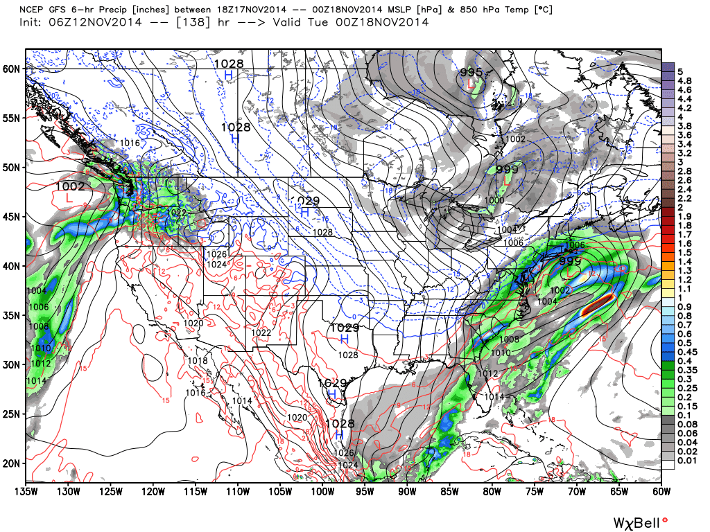
The next possibility is more interesting to me. This should occur this coming Monday-Tuesday. A stronger and better-defined low pressure system looks to form in the Gulf of Mexico and ride up the east coast and throw a decent amount of moisture inland. Guidance has been consistent on timing and precipitation amounts. The wildcard is where the snow/rain line will set up. I could see this being snow for NWNJ and cold rain for everyone else should lower level temperatures moderate too quickly. On the contrary, if the arctic boundary holds stubborn (like it did many times last year), then the snow/rain line could be further SE towards I-95. Regardless, I think coastal and SENJ see all rain with this one. The battleground between snow and rain will likely be inland. Here’s same upgraded GFS model/parameters as above but for 2PM through 7PM on Monday.
In English: The cold is coming and will be here for tomorrow. It could snow lightly Thursday night into early Friday morning with little to no accumulations expected. It could snow again NW of I-95 and rain SE of I-95 on Monday with accumulations only likely for interior/higher elevations of NWNJ. The rest of the weather (statewide), that surrounds these winter weather headlines into next week, will be cold and dry. Bundle up and be safe! JC
Jonathan Carr (JC) is the founder and sole operator of Weather NJ, New Jersey’s largest independent weather reporting agency. Since 2010, Jonathan has provided weather safety and forecasting services for New Jersey and immediate surrounding areas through the web, social media, and app spaces. Originally branded as Severe NJ Weather (before 2014), Weather NJ is proud to bring you accurate and responsible discussions ahead of high-stakes weather scenarios that impact the garden state. All Weather. All New Jersey.™


LOCAL FORECAST | INTERACTIVE RADAR | LATEST NJ WEATHER ALERTS | WEDDING FORECAST| PRIVACY POLICY
© Copyright 2024 Weather NJ LLC. All Rights Reserved.
Some information that can be found on our website is provided by a private weather station and is not an officially recognized station for weather reporting. Though we always strive to achieve accurate reporting for our own use, it is important that you do NOT depend on the data provided here for any purpose.
