

Nov 19: Lake Effect Snow Possible
Lake effect snowfall could close out the weekend for many in the Mid-Atlantic and Northeast US. Let’s break it down…
After a transient period of very mild weather, which included up through this afternoon, an upper-level trough will swing through the Mid-Atlantic and Northeast US. This will bring in a cold air mass just behind a mid-to-high latitude cyclone (low pressure system) tracking through the Great Lakes towards N Maine/SE Canada. With that said, we have two opportunities for precipitation.
First is along the cold front itself tonight-overnight. Most of this precipitation should start out as rain but could change over to snow, especially for NWNJ and surrounding areas. I don’t expect much wintry precipitation tonight SE of the I-95 corridor. It could happen but cold rain is more likley. This initial batch of precipitation should be concentrated linearly along the cold front. Once through, precipitation should lighten but winds should then howl out of the W/NW. This will set up our second chance for precipitation which would be Sunday into Sunday night and possibly overnight into some of Monday.
Because wind direction, out of the W/NW, will be stacked in parallel at multiple levels of the atmosphere (surface up through 500mb), there will be a strong moisture transport mechanism from the Great Lakes through our region. A fetch of very cold air aloft. Add to that the 50-degree+ surface temperatures of Lake Huron, Erie and Ontario and you have decent instability. This instability should build streaming snow squalls just SE of the Great Lakes which should be carried towards our region by the fetch.
Because the snowfall will likely be in the form of linear streamers that run from W/NW to E/SE, it’s very possible that some areas could see nothing while other areas get stuck under short periods of possibly moderate snowfall. In general NWNJ is favored over SENJ as far as light accumulations go. I don’t see much of any stickage happening SE of the I-95 corridor due to surface temperatures hanging onto recent warmth. Coversational snowfall is possible but meh on stickage. Areas NW of the I-95 corridor, especially the elevations of NWNJ have the best chance to see light accumulations.
The biggest story for most of us, aside from the possible scattered conversational flizzards, will be winds. I expect 15-25 mph sustained winds with gusts to 45mph between tonight and tomorrow night. I expect wind direction to remain out of the W/NW on Monday but at slightly less speeds. This long period of W/NW winds between tonight and Monday night will coincide with the overall cold air mass of the upper-level trough swinging through. We then moderate heading into Thanksgiving before another shot of cold Thanksgiving Weekend.
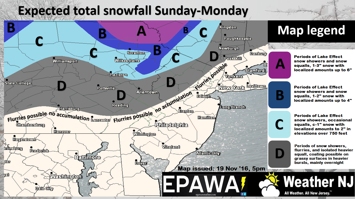
My Pocket Meteorologist alerts went out earlier this afternoon for those subscribed in the gray or light blue areas of the above snow map. Premium forum members saw the snow map even earlier as we discussed/drafted the information used to write this article. To sign up click the My Pocket Meteorologist image just below:

In English: Rain could start as early as 7-9PM tonight from W to E. It is possible that some of this precipitation could changeover to snowfall closer to midnight, mainly for NNJ and possibly some points S. No accumulations are expected with this initial batch of possible wintry precipitation as the ground will still be warm from recent weather. Precipitation (rain or wintry) should then let up as strong W/NW winds (gusts to 45mph) push through and set up possible lake effect snow bands for Sunday into Sunday night. The above snow map, collaborated by EPAWA staff and Weather NJ, illustrates our expected amounts for the region. It’s really not a big deal SE of I-95/or lower elevations…mostly conversational flurries. Most of SENJ shouldn’t expect much. This has the potential to be a light snow event for NWNJ though. Just to re-emphasize, the biggest story should be the strong and cold W/NW winds that dominate our pattern tonight through at least Monday. Wind chills will be a factor so dress and stay warm! Have a great rest of your weekend and please be safe! JC
Jonathan Carr (JC) is the founder and sole operator of Weather NJ, New Jersey’s largest independent weather reporting agency. Since 2010, Jonathan has provided weather safety and forecasting services for New Jersey and immediate surrounding areas through the web, social media, and app spaces. Originally branded as Severe NJ Weather (before 2014), Weather NJ is proud to bring you accurate and responsible discussions ahead of high-stakes weather scenarios that impact the garden state. All Weather. All New Jersey.™


LOCAL FORECAST | INTERACTIVE RADAR | LATEST NJ WEATHER ALERTS | WEDDING FORECAST| PRIVACY POLICY
© Copyright 2024 Weather NJ LLC. All Rights Reserved.
Some information that can be found on our website is provided by a private weather station and is not an officially recognized station for weather reporting. Though we always strive to achieve accurate reporting for our own use, it is important that you do NOT depend on the data provided here for any purpose.
