

Oct 5: Watch Out Eastern Florida and Coastal GA/SC!
The latest model output and live observations suggests a Florida landfall somewhere between West Palm Beach and Jacksonville, Florida. If not, then a track incredibly close to landfall! This update is for those with family and friends living along the SE US coast from Miami, FL through the coastal South Carolina.
Major hurricane conditions are possible within this expected landfall area, especially along immediate coastal regions. Areas inland will be less-subject to coastal flooding but equally subject to the dangerously high winds and heavy rainfall associated with Matthew. If your area is under mandatory evacuation, I strongly suggest you listen to the authorities.
EPAWA Chief Meteorologist Bobby Martrich and I have collaborated on the following impact map:
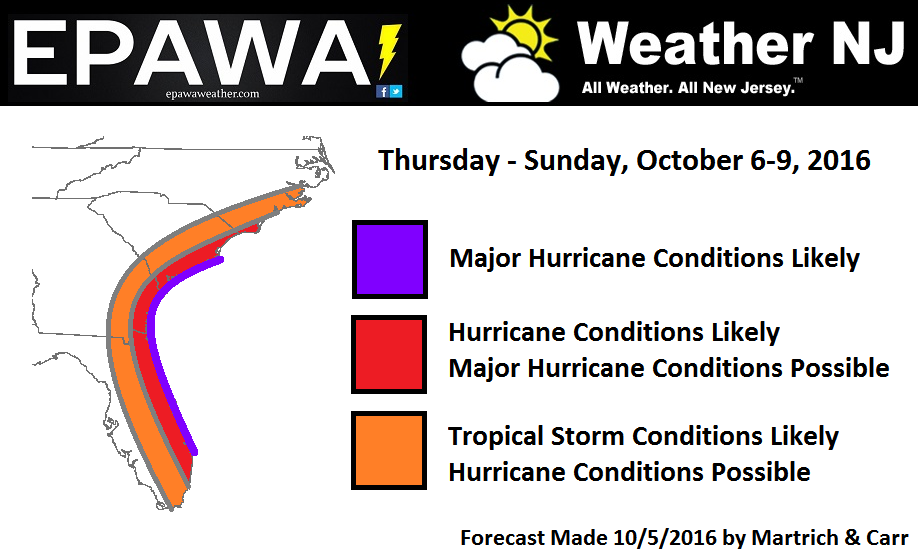
There is some uncertainty as to how long Matthew will remain a major hurricane as he traces the SE US coast northward into coastal Georgia and South Carolina. At some point he should weaken into a category 2 hurricane which is still dangerous but not as bad as a major hurricane (category 3 or higher). With that said, it’s best to play it safe with the expectation that he could remain a major hurricane all the way through to coastal South Carolina. The sooner he downgrades the better though. Right now Matthew is a category 3 hurricane and could possibly strengthen into a category 4 hurricane before SE US landfall.
The immediate focus right now are the Bahamas and E Florida over the next 24-36 hours but Georgia and South Carolina are on deck and in the hole through possibly Sunday morning.


In English: The SE US coast between Miami and coastal North Carolina are likely going to feel impacts from Hurricane Matthew in one form or another. Within that area, West Palm Beach, FL to Myrtle Beach, SC (coastal areas and slightly inland) are likely subject to the most dangerous conditions including but not limited to flash flooding from heavy rainfall, prolonged damaging winds, and life-threatening storm surge flooding. Lagoons and natural wetlands should allow water to push pretty far into coastal Florida. I would guess Orlando, FL would be the furthest west that major hurricane conditions would extend to in the worst case scenario which would obviously bring hurricane conditions to more of Florida. Let’s hope that doesn’t happen.
Timing: Matthew should begin his primary impact somewhere near ~West Palm Beach as early as noon tomorrow. He should move off the coast of ~South Carolina as late as Sunday morning. By Sunday night, he should steaming out to sea just SE of the OBX region with little impact N of the 35N parallel other than rip currents, elevated surf and possible rain along the approaching cold front.
Please listen to your SE US authorities if they issue mandatory evacuations. Weather is a poor choice to gamble with. Pass this along to your family and friends living in the areas mentioned in this article. Stay strong and be safe down there! JC
Jonathan Carr (JC) is the founder and sole operator of Weather NJ, New Jersey’s largest independent weather reporting agency. Since 2010, Jonathan has provided weather safety and forecasting services for New Jersey and immediate surrounding areas through the web, social media, and app spaces. Originally branded as Severe NJ Weather (before 2014), Weather NJ is proud to bring you accurate and responsible discussions ahead of high-stakes weather scenarios that impact the garden state. All Weather. All New Jersey.™


LOCAL FORECAST | INTERACTIVE RADAR | LATEST NJ WEATHER ALERTS | WEDDING FORECAST| PRIVACY POLICY
© Copyright 2024 Weather NJ LLC. All Rights Reserved.
Some information that can be found on our website is provided by a private weather station and is not an officially recognized station for weather reporting. Though we always strive to achieve accurate reporting for our own use, it is important that you do NOT depend on the data provided here for any purpose.
