

Oct 6: Matthew Approaches the Southeast US
Sometimes we are reminded that we are not in control. However, we once discovered that by taking an electrical current and simply shutting it on and off through oscillating patterns, that we could actually transfer data, not just power, through eventual lines of communication. And we’ve evolved that ability, using mathematics and scientific method, into being able to simulate weather conditions to the point of hypothesis while delivering real-time data to anyone on the planet. For that reason, a large amount of human beings living along the Southeast US have been notified of Major Hurricane Matthew’s potential impact. Many have listened to this safety awareness aggregation and have evacuated. For this reason many lives will be saved despite the practice of a non-exact and incomplete data science. Sometimes, the forecast ends up like Hermine’s. But it cases like this, we’re reminded why erring on the side of caution is and always will be the best thing to do, especially with our modern technological capabilities. This is what I have learned through my professional career in computer science and passionate hobby of practicing meteorology.
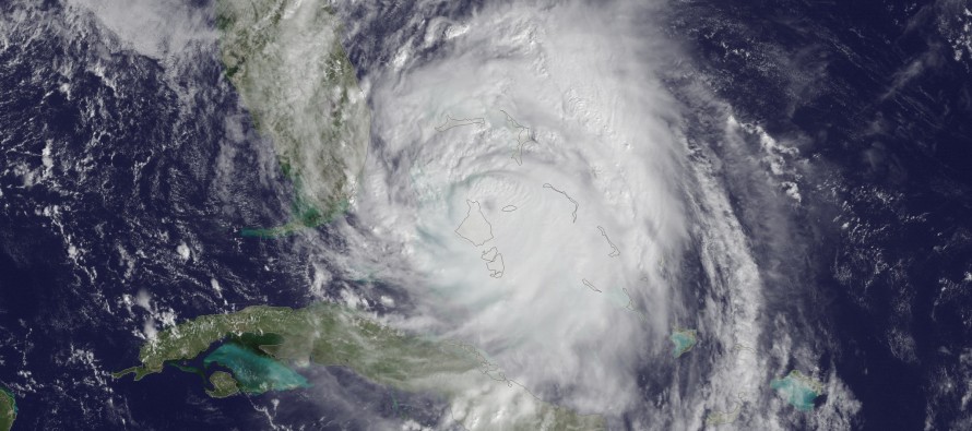
By now most of you have made your decision on whether or not to stay or leave. Therefore there is no point in pleading or arguing about it anymore. Matthew will hook around the exact curvature of the Southeast US coastline between tonight and Sunday morning. Whether or not a direct landfall is made (eye toughing the coast) he will likely bring major hurricane conditions (flooding rainfall, damaging winds and damaging storm surge) to parts of the central and northern Florida coast, coastal Georgia and coastal South Carolina. Loss of power is likely for said areas along with many other secondary inconveniences that accompany the primary threat of life-loss. By the time he gets to the coast of South Carolina, I expect a great deal of weakening, possibly loosing his major hurricane status. After that he should definitely lose his major hurricane status and shoot out to the east just to the south of the Outer Banks of North Carolina. It is still too early to talk about whether or not the mid-latitude westerlies will carry him away and out to sea or if he will make the bizarre loop and take another run at the Bahamas or even Florida. If he did take the loop, he would be much weaker when coming back around. Let’s revisit that on Sunday when he’s ejecting eastward into the Atlantic Ocean to the southeast of the Cape Hatteras.


In English: Direct landfall is still looking between West Palm Beach and Cape Canaveral in Florida. The storm is wobbling but overall still heading NE towards that general location. There is a small chance that the eye stays just off the coast when making the turn but I would prepare for direct landfall anyway. Regardless the heavier wind core should at least directly impact the coast through central/northern Florida, Georgia and South Carolina.
New Jersey has been off the hook from Matthew for a few days now and will likely just deal with some cold front-related rain on Saturday. The weekend outlook will be posted later this evening.
To those with family and friends in the expected area of impact…to my family and friends in the expected area of impact…please stay strong and be safe! JC
Jonathan Carr (JC) is the founder and sole operator of Weather NJ, New Jersey’s largest independent weather reporting agency. Since 2010, Jonathan has provided weather safety and forecasting services for New Jersey and immediate surrounding areas through the web, social media, and app spaces. Originally branded as Severe NJ Weather (before 2014), Weather NJ is proud to bring you accurate and responsible discussions ahead of high-stakes weather scenarios that impact the garden state. All Weather. All New Jersey.™


LOCAL FORECAST | INTERACTIVE RADAR | LATEST NJ WEATHER ALERTS | WEDDING FORECAST| PRIVACY POLICY
© Copyright 2024 Weather NJ LLC. All Rights Reserved.
Some information that can be found on our website is provided by a private weather station and is not an officially recognized station for weather reporting. Though we always strive to achieve accurate reporting for our own use, it is important that you do NOT depend on the data provided here for any purpose.
