

Ring of Fire Week Expected (June 15-19)

High pressure will setup in the SE US this week which will setup a classic “ring of fire” rainfall pattern.
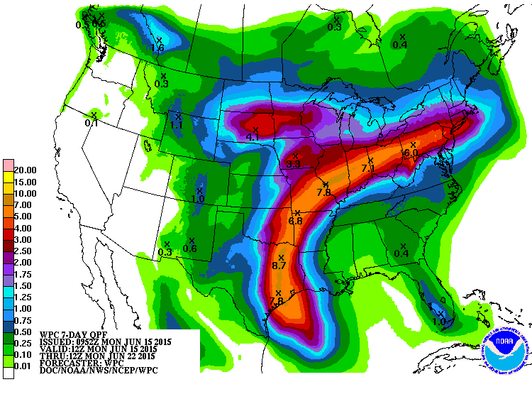
This will carry tropical disturbance remnant moisture from the W Gulf of Mexico over the central US and towards New Jersey. This next image represents expected rainfall amounts (in inches) over the next 7 days. You can see how the high pressure will carry the moisture around the NW quadrant of its anti-cyclonic (clockwise) flow.
Basically, New Jersey should be subject to a near-stationary frontal boundary that will act as a train rail for moisture and thunderstorm energy. Humid conditions are likely with thunderstorms possible every day, especially during late-afternoon/early evening hours. This pattern will likely be the theme for most of the week with a small break on Wednesday. Lets break each day down in English:
Monday should reach the mid-to-upper 80s for high temperatures. The day should be checkered with sun, tropical-looking clouds, humidity, showers, and storms. A decent chunk of the above expected rainfall is expected to fall throughout Monday. Winds should be light out of the W. Overnight lows should fall into the upper-60s for most of the state. Coastal regions could hover around 70 through sunrise Tuesday morning.
Tuesday should reach the mid-to-upper 80s for high temperatures. Most of the day should be sunny and humid but showers and storms are possible although more isolated than Monday. Winds should be light-to-breezy out of the W. Overnight lows should fall into the lower-60s for most of New Jersey. The upper elevations of NWNJ could slip into the upper-50s.
Wednesday should be noticeably cooler with inland highs topping out in the low-80s and coastal regions possibly staying in the 70s. Skies should be mostly sunny with just a few clouds here and there. Wednesday should be the driest day of the week. Winds should be light out of the E. Overnight lows should fall into the lower-60s for most of New Jersey. The upper elevations of NWNJ could fall into the upper-50s.
Thursday highs should reach the upper-70s and lower-80s statewide. Scattered showers and thunderstorms are possible all day. Otherwise there should be periods of sun between. Winds should be light out of the S/SE. Overnight lows should fall into the 60s statewide.
Friday should reach well into the 80s for most of the state. Skies should be mostly sunny with humid conditions. This will present the threat for more afternoon-early evening thunderstorms. Winds should be light out of the W. Overnight lows should fall into the lower-60s for most of New Jersey. The upper elevations of NWNJ could fall into the upper-50s.
An early look at the weekend indicates more hazy, hot and humid conditions with showers and thunderstorms possible. The ring of fire…
This Monday-Friday Outlook is proudly sponsored by weathertrends360 (www.weathertrends360.com). Through 150 years of world wide weather data analysis, weathertrends360 has developed proprietary algorithms and methods that predict weather up to a year with 84% accuracy. They are second to none in the long range so check them out for business planning, travel planning, etc.
Be safe and have a great week! JC
Jonathan Carr (JC) is the founder and sole operator of Weather NJ, New Jersey’s largest independent weather reporting agency. Since 2010, Jonathan has provided weather safety and forecasting services for New Jersey and immediate surrounding areas through the web, social media, and app spaces. Originally branded as Severe NJ Weather (before 2014), Weather NJ is proud to bring you accurate and responsible discussions ahead of high-stakes weather scenarios that impact the garden state. All Weather. All New Jersey.™


LOCAL FORECAST | INTERACTIVE RADAR | LATEST NJ WEATHER ALERTS | WEDDING FORECAST| PRIVACY POLICY
© Copyright 2024 Weather NJ LLC. All Rights Reserved.
Some information that can be found on our website is provided by a private weather station and is not an officially recognized station for weather reporting. Though we always strive to achieve accurate reporting for our own use, it is important that you do NOT depend on the data provided here for any purpose.

)