

Sept 20: US Landfall Not Off Table
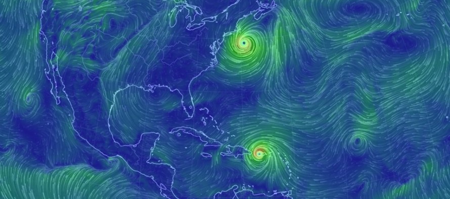
Discussion: Up until yesterday, most long-range model guidance was grim with respect to Maria and the US East Coast. Most had a direct landfall for the SE US. Yesterday there were signs of improvement as about half of the models backed off on east coast landfall. The trend has continued today however not all models are offshore. Most are though. After observing the actual building ridge over the E US and Jose’s fringe influence, I’m about 70/30 on an out to sea miss/east coast hit for Maria early-to-mid next week.
In the immediate period, we have Jose drifting slightly eastward as a strong tropical storm and Maria heading towards the E Bahamas (likely to graze NE Hispaniola). Maria has just been downgraded to a strong category 2 hurricane but is expected to re-intensify into a category 3 over warmer E Bahamas water. I could see Maria trying to flex into a category 4 one last time in the Bermuda Triangle but category 3 is the safer bet. I’m fairly confident that an east coast landfall, especially a New Jersey landfall, would be a category 3 or less hurricane given the colder ocean temperatures and wind shear.
Jose will initially hold the door open through the ridge for Maria to head towards. Once Jose fizzles out completely the ridge will fill in the void. This ridge could then temporarily block Maria and force N/NW or even NW movement towards OBX/Delmarva/New Jersey/NYC/LI/coastal New England. Eventually a trough is modeled to come in from the W and sweep Maria away to the east. The big question is how close does Maria get to the east coast before the eastward sweep away happens. Again, most model guidance today keeps Maria’s track offshore but some models keep it uncomfortably close. Jose’s remnant upper level energy, the ridge and the approaching tough will be the upper level players I’ll continue to monitor for trends.
Friday will be go-time for serious tracking if Maria still has a small chance for east coast landfall. In the meantime, Eastern PA Weather Authority Meteorologist Bobby Martrich and myself will be discussing deep technical model analysis in our Premium Forum. Our conversations in this forum provide even more of a technical dive than this article including live run-by-run model analysis and the conclusive insight that helps ultimately drive these public articles. While you’re there, have a peek at our other premium products such as our hyper-local text notification system for daily forecasts and severe weather. Thousands of people have signed up for these premium services and thoroughly enjoy them, especially during the winter months. Not to worry, my free services (articles like this and outlooks) will always remain free as-is. These premium services are mostly for business owners and weather nerds/freaks like me who absolutely have to know the latest info as soon as we learn of it.
In English: If Maria is going to hit the east coast, especially New Jersey, it would be in the ~September 26-28 period. Right now I’m about 70/30 on an out to sea miss/east coast hit for Maria early-to-mid next week. My next public update will likely be Friday morning. If there is still a small chance for Maria landfall on the east coast at that time, then we will start serious tracking. I should have a good idea by then as most upper-level players will be set on the chess board. The key takeaway tonight is that an east coast hit is not yet off the table, even though most model guidance currently favors such. Have a great night and please be safe! JC
Jonathan Carr (JC) is the founder and sole operator of Weather NJ, New Jersey’s largest independent weather reporting agency. Since 2010, Jonathan has provided weather safety and forecasting services for New Jersey and immediate surrounding areas through the web, social media, and app spaces. Originally branded as Severe NJ Weather (before 2014), Weather NJ is proud to bring you accurate and responsible discussions ahead of high-stakes weather scenarios that impact the garden state. All Weather. All New Jersey.™


LOCAL FORECAST | INTERACTIVE RADAR | LATEST NJ WEATHER ALERTS | WEDDING FORECAST| PRIVACY POLICY
© Copyright 2024 Weather NJ LLC. All Rights Reserved.
Some information that can be found on our website is provided by a private weather station and is not an officially recognized station for weather reporting. Though we always strive to achieve accurate reporting for our own use, it is important that you do NOT depend on the data provided here for any purpose.
