

Sept 28: Matthew Threat Increasing
Tropical Storm Matthew is currently entering the E Caribbean Sea. It is now becoming apparent that a US East Coast hit or at least secondary impacts are possible later next week. Let’s break it down…
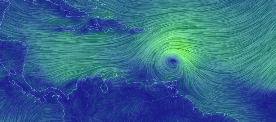
Matthew took some time to form a closed-off lower-level circulation. Because of this delay, Matthew was named about 6-12 hours later than expected. Given the fact that tropical storm graduation was made with 60mph sustained winds, I think Matthew should graduate to hurricane status sooner than later as he further moves into the central Caribbean Sea. All guidance and expectations are fairly confident in Matthew moving into the center of the Caribbean Sea before making his turn northward. From that point and forward, the uncertainty still increases but has somewhat narrowed.
It would be irresponsible of me to throw up a model graphic of Matthew hitting Mid-Atlantic US at this point. Maybe once there is more confidence in the mid-to-short range forecasting period, but NOT this far out. I will however mention that my go-to model blend has been showing hit after hit after hit in the long range (7-10 days away). The most I am comfortable saying is that a track (or cone of uncertainty rather) between a Florida hit and slightly out-to-sea solution is starting to take shape.
I think a track into the Gulf of Mexico (missing Florida to the S completely) is becoming less likely as is a track far out to sea. With that said, the entire US East Coast should be on alert as we further approach and pinpoint the most likely impacts. Obviously a landfall would bring the worst-case scenario to the coastal area of impact but even a slightly out-to-sea solution would still have secondary impacts (less wind obviously but still rain and coastal flooding). With that said, a US East Coast threat is increasing in likelihood.
This is all going to come down to the upper-level setup over North America when Matthew decides to turn to the N. If a trough is moving across ahead of Matthew then he will get lifted out to the NE. If a ridge is moving across ahead of Matthew then he will get stalled or possibly turned into the US East Coast. As I’ve been saying, I won’t know the upper level pattern until Matthew is crossing the N Caribbean Islands somewhere between E Cuba, Hispaniola, Jamaica, or Puerto Rico (although Puerto Rico is looking less likely). I expect this to happen around Sunday which should set up a much more confident analysis of where exactly Matthew will track. For now, the models are showing a perfectly positioned ridge of high pressure to the N/NE and a diving upper-level trough to the NW. If this verified verbatim, it would steer Matthew directly up the coast towards New Jersey. Let’s watch the model guidance evolve as we monitor live observations of the upper-level pattern.

In English: Matthew has formed and will strengthen in the Caribbean Sea through this weekend. He should then turn northwards and escape the Caribbean Sea around Sunday, just as Sandy did. After that there is tremendous uncertainty as to whether Matthew will hit Florida, brush the US East Coast or stay slightly out to sea. Either way rain, wind and coastal flooding are becoming more probable towards the second half of next week and all US East Coast interests should be monitoring in case this comes into fruition. I’ll be starting videos soon but we’re not there just yet. Let’s see how Matthew behaves in the Caribbean first. Thank you all for your patience and understanding. Please be safe! JC
Jonathan Carr (JC) is the founder and sole operator of Weather NJ, New Jersey’s largest independent weather reporting agency. Since 2010, Jonathan has provided weather safety and forecasting services for New Jersey and immediate surrounding areas through the web, social media, and app spaces. Originally branded as Severe NJ Weather (before 2014), Weather NJ is proud to bring you accurate and responsible discussions ahead of high-stakes weather scenarios that impact the garden state. All Weather. All New Jersey.™


LOCAL FORECAST | INTERACTIVE RADAR | LATEST NJ WEATHER ALERTS | WEDDING FORECAST| PRIVACY POLICY
© Copyright 2024 Weather NJ LLC. All Rights Reserved.
Some information that can be found on our website is provided by a private weather station and is not an officially recognized station for weather reporting. Though we always strive to achieve accurate reporting for our own use, it is important that you do NOT depend on the data provided here for any purpose.
