

Sept 3: East Coast Irma Landfall Chances Increasing
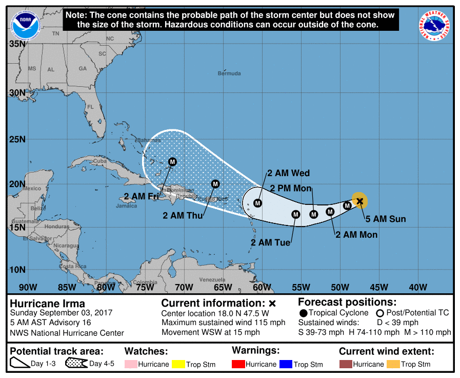
Discussion: The immediate concern remains for the NE Caribbean Islands/Lesser Antilles. Everyone from the Haiti/Dominican Republic area through about Martinique/St. Lucia should be preparing for at least some level of tropical impact even if just outer fringe spiral band interaction. The NE-most islands (Anguilla/Barbuda) have the greatest chance of tropical impact. Timing for this area would be between early Tuesday AM and late Thursday PM as indicated by the latest National Hurricane Center update:
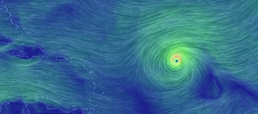
As you can see, Irma is currently a major hurricane and is expected to strengthen as she moves over the Jacuzzi-warm waters of the general NE Caribbean/Bahamas region. She is currently moving W/SW and is expected to continue the southward drift until late-Monday/early-Tuesday. It is very important how long Irma remains south of the 20N parallel. The longer she stays south of 20N, the better chance she has of missing the E US trough connection which would be our saving grace out to sea track. I’m starting to use the island of Puerto Rico as a point of reference. If Irma is still at or S of 20N when nearly passing Puerto Rico then she will likely come our way here in the Mid-Atlantic US. If Irma turns back to the N and passes Puerto Rico N of the 20N parallel, then there is a better chance of an out-to-sea miss for us. We should know this point of reference outcome by late-Wednesday night.
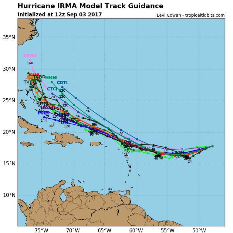
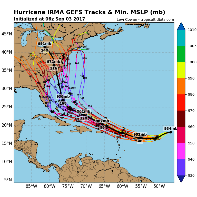
Regardless, east coast impact chances are growing stronger. Yesterday I wanted to express some relief that the European Ensembles (currently best data on the planet IMO) were mostly out to sea but now they have taken a step west with most having east coast impact and only some out to sea. The Canadian is not typically a model I use for tropical origin systems as it has a documented poor history with tropical cyclones. I find the Canadian to be much more reliable for northern stream systems in the winter and therefore I’m placing little weight into it for Irma. The GFS is struggling with intensity prediction (over-amplification of SE US) but has consistently modeled direct landfall for the Mid-Atlantic US, primarily the SC/NC area. Again, this is all adding up to a stronger chance of east coast landfall for me. But not yet 100% The goal over this holiday weekend was to discard the many different surface solutions and get an overall picture of model guidance as it evolves by tomorrow or Tuesday. You cannot however discard the consistency as indicated by the following tropical spaghetti and GFS ensemble member spread:
We still have another day to analyze the models for any consistent trends in the upper-level pattern. However if we are still in the same place tomorrow morning then I will be recommending that New Jersey and surrounding areas begin exercising hurricane safety plans. Should current guidance hold into Tuesday morning then it will be all systems go. My initial timing prediction for Irma on the east coast (NJ and surrounding areas) was Sept 9-12. I’m now able to narrow that down to the Sept 11-12 period (next Monday into Tuesday).
In English: I don’t like what I see right now. I’m hoping we see a trend towards an out to sea solution by tomorrow. If not, it is time to start preparing for an east coast landfall with possibly a destructive outcome for New Jersey and surrounding areas in the September 11-12 period. Given the classic Cape Verde re-curving nature of the track, a hit into the South Carolina or North Carolina coast would likely weaken Irma for NJ impacts shortly beyond. However if Irma were to just graze the Outer Banks of North Carolina then there would be less weakening and possibly a stronger hit for the New Jersey/NYC area. I’m really hoping for the out to sea trend between today and tomorrow. Otherwise it’s time to start preparing. Be safe! JC
Jonathan Carr (JC) is the founder and sole operator of Weather NJ, New Jersey’s largest independent weather reporting agency. Since 2010, Jonathan has provided weather safety and forecasting services for New Jersey and immediate surrounding areas through the web, social media, and app spaces. Originally branded as Severe NJ Weather (before 2014), Weather NJ is proud to bring you accurate and responsible discussions ahead of high-stakes weather scenarios that impact the garden state. All Weather. All New Jersey.™


LOCAL FORECAST | INTERACTIVE RADAR | LATEST NJ WEATHER ALERTS | WEDDING FORECAST| PRIVACY POLICY
© Copyright 2024 Weather NJ LLC. All Rights Reserved.
Some information that can be found on our website is provided by a private weather station and is not an officially recognized station for weather reporting. Though we always strive to achieve accurate reporting for our own use, it is important that you do NOT depend on the data provided here for any purpose.
