

Sept 4: Irma Uncertainty Remains
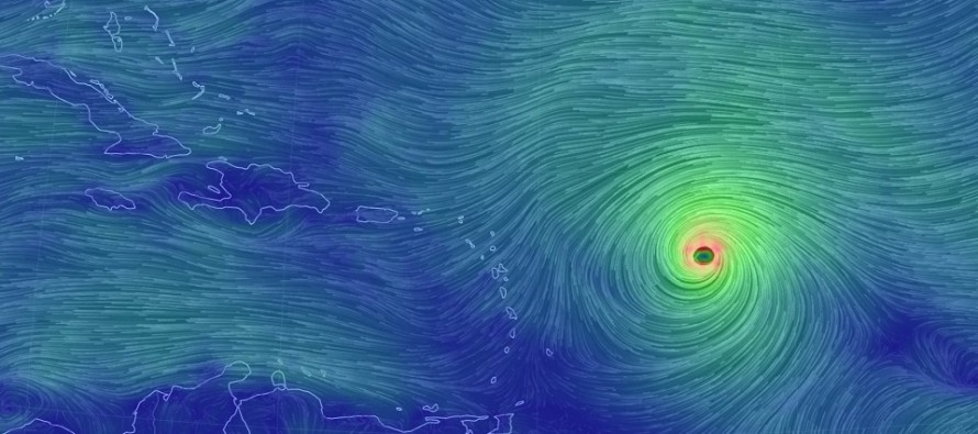
Discussion: The northern Lesser Antilles are facing direct impact from Major Hurricane Irma as early as Tuesday night but certainly by Wednesday morning. Secondary impacts in the form of rain and wind (run of mill for the area) should be expected as far south as ~Martinique/St. Lucia. The Anguilla/Barbuda area of the islands however are on deck for the hardest initial hit, as indicated by the National Hurricane Center’s latest update:
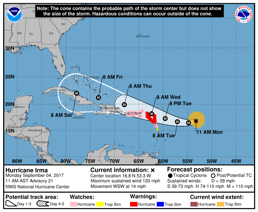
Impacts beyond the northern Lesser Antilles remain very uncertain as they are highly dependent on the volatile E US upper-level pattern. What we are starting to see however is a track closer to Puerto Rico and possibly even Hispaniola/Cuba in the day 3-5 period. Hispaniola has many elevations over 5,000 feet with its peak reaching a little over 10,000 feet. These elevations are known to weaken tropical cyclones via geographic influences. If Irma passes too close to Hispaniola and possibly even Cuba then we might see such weakening occur. If Irma passes far enough to the NE of Hispaniola and Cuba then there would be less geographic-related weakening as Irma stays over extremely warm water. Regardless, this most recent W/SW trend in track direction is looking much worse for the Bahamas in the day 4-5 period (Friday-Saturday, Sept 8-9.
E US impacts remain speculative, much more speculative than I thought they would be at this point in time. My position heading into this holiday weekend was to give it until Tuesday to begin serious tracking. I will be keeping that plan. I will state however that the uncertainty will likely not be narrowed as much as the general public would like it to be tomorrow. This system has been trending slower…the main reason for possibly missing the E US upper-level trough connection. Overnight models had fresh flight recon data injected into them and they still sprayed solutions from Florida to North Carolina for landfall. We can assume however that a North Carolina landfall, especially an OBX landfall, could have New Jersey impacts shortly afterward. A landfall closer to Florida would likely mean New Jersey is spared from devastating impact. We’re just not there yet. I expect more sprayed solutions along the SE US/Mid-Atlantic today.
In the meantime, Eastern PA Weather Authority Meteorologist Bobby Martrich and myself will be discussing deep technical model analysis in our My Pocket Meteorologist Premium Forum (bottom option). Our conversations in this forum provide conclusive insight for the daily public articles released afterward like this one. While you’re there, have a peek at our other premium products such as our hyper-local text notification system for daily forecasts and severe weather. Thousands of people have signed up for our joint-ventured products and thoroughly enjoy them, especially during the winter months. Not to worry, my free services will always remain as-is. These premium services are mostly for business owners and weather nerds/freaks like me who absolutely have to know the latest info as soon as we learn of it.
In English: It’s very certain that the northern Lesser Antilles are in extreme danger tomorrow night into Wednesday morning. It’s then becoming a little more certain that Irma will take a track closer to Puerto Rico, Hispaniola and possibly Cuba through Saturday. This would be very bad for the Bahamas during that period. Impacts beyond Saturday (for the US) are still very uncertain as Irma is expected to curve to the NW and ultimately to the N. At this point everyone between Florida and North Carolina should still be watching closely. A landfall closer to Florida would mean much less potential impact for New Jersey. A landfall closer to NC keeps New Jersey on the table for at least secondary impacts with primary impact still not completely off the table. We’re just not there yet but we should be that much closer tomorrow. You should continue to have a hurricane safety plan in place regardless of whether you will need to start exercising such later this week. Have a great Labor Day and please be safe! JC
Jonathan Carr (JC) is the founder and sole operator of Weather NJ, New Jersey’s largest independent weather reporting agency. Since 2010, Jonathan has provided weather safety and forecasting services for New Jersey and immediate surrounding areas through the web, social media, and app spaces. Originally branded as Severe NJ Weather (before 2014), Weather NJ is proud to bring you accurate and responsible discussions ahead of high-stakes weather scenarios that impact the garden state. All Weather. All New Jersey.™


LOCAL FORECAST | INTERACTIVE RADAR | LATEST NJ WEATHER ALERTS | WEDDING FORECAST| PRIVACY POLICY
© Copyright 2024 Weather NJ LLC. All Rights Reserved.
Some information that can be found on our website is provided by a private weather station and is not an officially recognized station for weather reporting. Though we always strive to achieve accurate reporting for our own use, it is important that you do NOT depend on the data provided here for any purpose.
