

Sept 6: Hermine Inches Closer
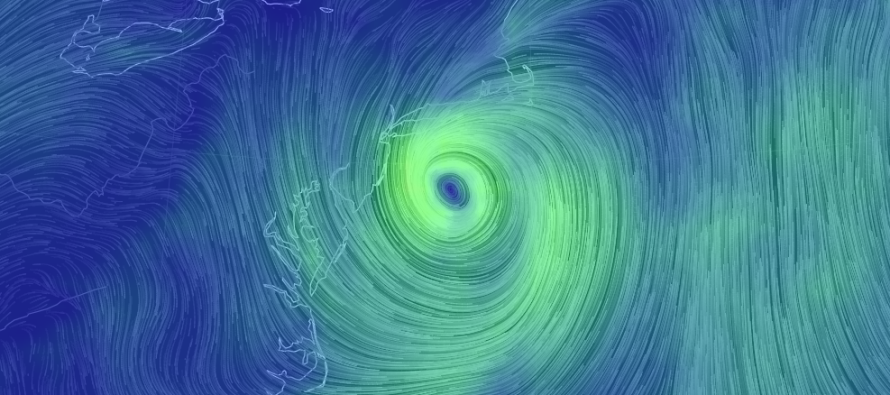
Hermine is still packing sustained winds of 60mph and a central pressure of 997mb. She will continue to drift W towards New Jersey over the next 24-36 hours before fizzling out and pulling away. She might even turn a little to the W/SW today. Her current heading is W at 3mph and all stated data is per the National Hurricane Center’s flight recon data.
This places the center of Hermine pretty close to the Jersey Shore for a prolonged duration. This positioning and duration would normally suggest at least moderate coastal flooding and beach erosion but I think the northerly wind direction around her W side will help reduce those threats some, as opposed to E or E/NE flow if she was to our SE. The surface low is close to being stacked under the upper-level low so she should now spin out and use up all remaining energy available before either fizzling or absorbing into another upper-level trough moving through later in the week.
We should still see some above-average tide levels today and tomorrow but there is uncertainty as to how high those water levels will get. The most probable scenario is minor levels but a small chance of moderate levels still exist for the Jersey Shore. I could now see northern Jersey coast areas seeing slightly higher levels than southern Jersey coast areas simply due to proximity of onshore flow. Long Island should be feeling it pretty good right now. I’ll be keeping an eye on this as she further approaches.
Winds should be felt moreso along the coast than areas away from the ocean. Again, Hermine is packing 60mph winds around it’s core. The closer the core gets to New Jersey, the windier it will be. I could see 20-30mph sustained winds with gusts to 40+ still on the table today into tomorrow for the coast. Again, areas away from the coast…lesser winds.
Rain is the least important aspect of this system and it always was. Regardless, still only a chance for some outer bands of rain to make it off the ocean and onto New Jersey land.
Hopefully this system is pulling out by tomorrow afternoon/evening. After that, warm and humid conditions should return and take us into the weekend.
In English: Areas inland are subject to minor/moderate winds out of the north for the next 24-36 hours. Coastal areas are subject to sustained 20-30mph winds with gusts to 40+. Rainfall is very low on the totem pole of priority but there is a chance for some to come off the ocean over the next 24-36 hours. Coastal flooding should be anywhere from minor to moderate depending on how the long-duration/perfect positioning of Hermine’s remnants affects us. Beach erosion and rip currents will continue to occur.
I found it interesting how Hermine hit the Florida Panhandle 2 days later than expected due to her wide turn through the Gulf of Mexico and will now impact NJ the most 2 days later than expected due to her wide turn in the Atlantic Ocean. I’m very happy that she will be much weaker though. Have a great day and be safe! JC
Jonathan Carr (JC) is the founder and sole operator of Weather NJ, New Jersey’s largest independent weather reporting agency. Since 2010, Jonathan has provided weather safety and forecasting services for New Jersey and immediate surrounding areas through the web, social media, and app spaces. Originally branded as Severe NJ Weather (before 2014), Weather NJ is proud to bring you accurate and responsible discussions ahead of high-stakes weather scenarios that impact the garden state. All Weather. All New Jersey.™


LOCAL FORECAST | INTERACTIVE RADAR | LATEST NJ WEATHER ALERTS | WEDDING FORECAST| PRIVACY POLICY
© Copyright 2024 Weather NJ LLC. All Rights Reserved.
Some information that can be found on our website is provided by a private weather station and is not an officially recognized station for weather reporting. Though we always strive to achieve accurate reporting for our own use, it is important that you do NOT depend on the data provided here for any purpose.
