

Sept 7: Irma Destruction Continues. Watching Jose
Discussion: Irma has caused catastrophic damage to Barbuda, St. Martin and the British Virgin Island region. She has tracked just to the north of Puerto Rico and Hispaniola, sparing them from the catastrophic inner wind field and is now taking aim at Turks and Caicos and most of the Bahamas. The latest 5PM update from the National Weather Service is as follows:
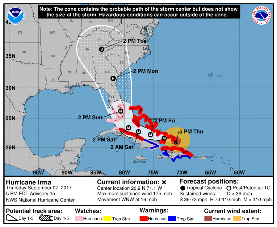
Irma should impact most of the Bahamas, especially the southern islands before tracking near Cuba Friday night into Saturday morning. She is then expected to make landfall, if not very close to landfall, in southern Florida as early as Sunday morning. The Keys and Miami are in a very bad spot right now as almost all model guidance is locked into that area with no live observations suggesting otherwise. Irma should then move northward towards Georgia and South Carolina between Sunday PM hours and early Tuesday morning. Between Tuesday morning and Tuesday evening she will weaken over land however New Jersey should expect some non-destructive rain and wind Tuesday into Wednesday morning. I’m now leaning even more towards her remnants not being a big deal for New Jersey. The main areas of danger are still Florida, Georgia and South Carolina…possibly some western areas of North Carolina. I’m still thinking the main eye path will be in the general Miami, FL to Charleston, SC area, again in the Sunday morning to Tuesday morning period.
One possibility I see is some slight weakening from the elevations of Hispaniola via geographic influences. It might take 10-20mph off Irma’s current sustained wind values but that still likely leaves a category 5 system heading towards Florida. Also, Irma will pass over a favorable area for development after Hispaniola south flow disruption is no longer in the equation. Just something to watch.
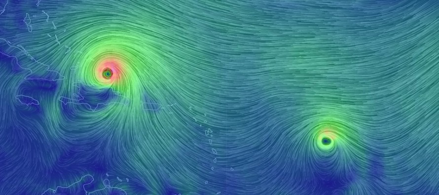
Jose is still very hard to read however he is showing some impressive signs of development. He just became a category 3 major hurricane. Unfortunately he will likely pass through the northern Lesser Antilles this Saturday…areas just devastated by Irma. After that Jose will likely turn north and head back out to sea. What has me interested/concerned is the potential loop Jose could make and take aim back at the Caribbean region and possibly the US in the future. I am far from confident in this idea but it has been showing up on the long range Euro. We have a lot of time to track Jose. But for now, just know that it’s out there.
Katia will make landfall in Mexico and quickly weaken over elevations. Lee is expected to form behind Jose, also a long-range Euro prospect. The 2017 Hurricane Season continues to be extremely active.
In the meantime, Eastern PA Weather Authority Meteorologist Bobby Martrich and myself will be discussing deep technical model analysis in our My Pocket Meteorologist Premium Forum (bottom option). Our conversations in this forum provide even more of a technical discussion than this article including the conclusive insight that helps ultimately drive these articles. While you’re there, have a peek at our other premium products such as our hyper-local text notification system for daily forecasts and severe weather. Thousands of people have signed up for these products and thoroughly enjoy them, especially during the winter months. Not to worry, my free services (daily articles and outlooks) will always remain free as-is. These premium services are mostly for business owners and weather nerds/freaks like me who absolutely have to know the latest info as soon as we learn of it.
In English: Irma will continue to devastate the Bahamas and likely Florida/Georgia/South Carolina region between now and Tuesday. Florida landfall in the Keys/Miami area would be Sunday AM. Whether the eye itself makes it over Miami/S FL or stays just offshore will have little impact on the danger level. People in that area should respect all evacuation orders. New Jersey should expect non-destructive rainy and windy Irma remnants Tuesday into Wednesday morning. I don’t think it will be too bad at all. Have a nice night and please be safe! JC
Jonathan Carr (JC) is the founder and sole operator of Weather NJ, New Jersey’s largest independent weather reporting agency. Since 2010, Jonathan has provided weather safety and forecasting services for New Jersey and immediate surrounding areas through the web, social media, and app spaces. Originally branded as Severe NJ Weather (before 2014), Weather NJ is proud to bring you accurate and responsible discussions ahead of high-stakes weather scenarios that impact the garden state. All Weather. All New Jersey.™


LOCAL FORECAST | INTERACTIVE RADAR | LATEST NJ WEATHER ALERTS | WEDDING FORECAST| PRIVACY POLICY
© Copyright 2024 Weather NJ LLC. All Rights Reserved.
Some information that can be found on our website is provided by a private weather station and is not an officially recognized station for weather reporting. Though we always strive to achieve accurate reporting for our own use, it is important that you do NOT depend on the data provided here for any purpose.
