

Sept 9: East Coast Landfall Likely
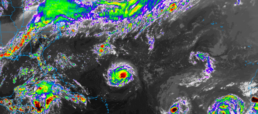
Discussion: Per the latest 5pm update from the National Hurricane Center, Hurricane Florence is now located at ~24.4N 57W and moving W at 7mph. Flight recon shows a central pressure of 975mb and sustained winds of 85mph.
The hopeful escape to the N via trough connection ship has sailed. With Florence continuing westward under the trough now, the connection will not happen. Therefore I’m all-in on Florence getting caught beneath the ridge from tomorrow-forward. Florence’s exact east coast landfall location is still uncertain but model guidance has tightened it to the coast of NC between Bald Head Island and Cape Hatteras.
This will now all come down to the strength and position of the ridge. If the ridge is weaker and further to the NE then Florence is allowed a path more towards Cape Hatteras. If the ridge is stronger and further to the NW then Florence will get trapped into the S side of landfall expectations (closer to SC/NC border). This is still yet to be determined from the 4.5 day out forecasting period.
Regardless of a S or N landfall in coastal NC, New Jersey is slowly escaping the possibility of a direct landfall. Given the high pressure associated with the steering ridge, there might be a very sharp cut-off in precipitation on the N side of Florence, even if spinning just off Cape Hatteras. Little to no precipitation would be expected N of the Mason-Dixon line. New Jersey impacts would be limited to mostly-cloudy skies with breaks of sun and sprinkles, breezy-to-moderate winds and moderate-to-major coastal flooding.
There is a small wildcard chance that Florence could miss the expected landfall zone either N or S of the NC coast. A S miss of that area would mean more impact for GA/SC. A N miss would bring Delmarva and at least part of NJ into the equation. This small wildcard is probably a 10-20% chance. Otherwise there is an 80% chance that New Jersey is spared from direct Florence impacts (if landfall occurs between the anticipated coastline of NC. A bad sign would be if Florence intensified faster than the already rapid-intensification expectation.
What’s becoming interesting to me is the possible gale wind (non-tropical) in the Sunday-Tuesday period as the remnants of Florence finally get picked up by the jet stream. The most concerning aspect of this would be the prolonged onshore flow between this Thursday and next Tuesday. That could present serious coastal flooding problems and needs to be watched. After Tuesday, all of NJ would likely be looking at crisp fall-like conditions with a dominating N wind wrapping in behind the departing system.
In English: Florence will likely make landfall in the coastal NC region between Bald Head Island and Cape Hatteras on Thursday.
What does this mean for New Jersey?
For the weekend it means partly-to-mostly cloudy skies with possibly some light precipitation, pesky onshore flow (felt more at the coast than inland) but possibly moderate-to-major coastal flooding for Delaware Bay and Atlantic Ocean-facing NJ coasts. Rain, wind and coastal flooding concerns could now increase for the Sunday-Tuesday period should the remnants of Florence take a close pass to NJ when departing. This would come in the form of a gale, not a tropical core system. The rain and or wind would be run of mill but the extended period of onshore flow-driven flooding would not be good for coastal interests. Just to repeat what I mentioned above, there is still a super-small chance of track surprise. Any surprises that take this current NJ forecast downward will be blasted out publicly as soon as identified. Otherwise I’m 80%/20% on NJ spared/NJ hit.
What does this mean for SC/NC/Virginia?
This would likely be a dangerous/catastrophic/dangerous scenario for SC/NC/Virginia between Thursday and Friday…flooding rain, damaging winds and historic flooding. Intensity could range from a category 3 to 5 major hurricane upon landfall.
Everyone please stay calm, get prepared along the SNJ coastline just in case, and be safe! JC
Image Credit; NOAA GOES-16
Jonathan Carr (JC) is the founder and sole operator of Weather NJ, New Jersey’s largest independent weather reporting agency. Since 2010, Jonathan has provided weather safety and forecasting services for New Jersey and immediate surrounding areas through the web, social media, and app spaces. Originally branded as Severe NJ Weather (before 2014), Weather NJ is proud to bring you accurate and responsible discussions ahead of high-stakes weather scenarios that impact the garden state. All Weather. All New Jersey.™


LOCAL FORECAST | INTERACTIVE RADAR | LATEST NJ WEATHER ALERTS | WEDDING FORECAST| PRIVACY POLICY
© Copyright 2024 Weather NJ LLC. All Rights Reserved.
Some information that can be found on our website is provided by a private weather station and is not an officially recognized station for weather reporting. Though we always strive to achieve accurate reporting for our own use, it is important that you do NOT depend on the data provided here for any purpose.
