

Side Effects of Florence (Sept 14-16)
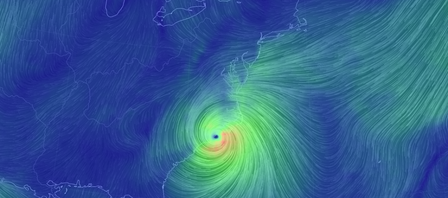
Discussion: Hurricane Florence is stuck directly under the ridge now as it crawls into coastal NC. A slow-to-depart upper-level low to the SW of Florence resulted in some weakening yesterday. That and a failed Eye Wall Replacement Cycle (EWRC). For this reason Florence is now a strong 2 (might still get close to a 3 before landfall due to gulf stream influence). Landfall should occur where my gut feeling has been the past few days, between Bald Head Island, NC and Cape Lookout, SC. Right now it appears it will be closer to Bald Head Island/Wilmington, NC but still within that coastal range. Life-threatening storm surge, flooding rainfall and damaging winds are still expected for the coastal NC/SC area later this evening into and likely through tomorrow. The wind field has expanded regardless of how strong the inner eye wall winds are. This should produce a worse storm surge than expected. After landfall, Florence should then track to the SW a bit along the coast. After getting near the Myrtle Beach, maybe Charleston area, it should then lift up and absorb into the jet stream. If the remnants lift out further to New Jersey’s west, then they should come through mid-next week as a frontal passage. If the remnants lift out in a more direct N manner then we’re looking at more of a non-tropical synoptic rain and wind storm in the Monday-Tuesday period. I’ll be able to determine this by Sunday. Due to the SE US landfall instead of N Mid-Atlantic US landfall, our tidal concerns are somewhat eased this weekend. We’ll still see dangerous rip tides and slightly elevated tidal cycles but nothing that bad IMO. We are very lucky to be feeling Florence’s side effects rather than primary effects.
Friday (Sept 14) high temperatures should reach the mid-to-upper 70s statewide. Skies should be mostly cloudy with a few passing showers. NNJ has the best chance to see the sun poke through. SNJ has the best chance to stay completely cloudy and wet. Winds should be light-to-breezy inland out of the E. Coastal regions should see gusts to 20mph with sustained winds in the 10-15mph range. Tides should be slightly elevated with dangerous rip currents. Overnight lows should range from 60-70 NNJ to SNJ.
Saturday (Sept 15) high temperatures should reach the mid-to-upper 70s for most. Some interior locations could flirt with 80. Skies should be partly sunny with a humid feel. I hope to see you all at the 4th Annual Makers Festival! Winds should be light-to-breezy out of the E/NE for most areas inland with gusts to 20-25mph along the coast. Overnight lows should range from upper-50s to upper-60s NNJ to SNJ.
Sunday (Sept 16) high temperatures should reach near-80 statewide. Skies should be partly sunny and humid. A stray shower is possible. Winds should be light-to-breezy out of the E for most. Coastal regions could still see gusty conditions but likely less stiff than Friday and Saturday were. Overnight lows should range from 60-70 NNJ to SNJ.
An early look at next week indicates the remnants of Florence possibly moving over New Jersey to start the week. This could mean non-tropical rain and wind. This is still very uncertain so I will play it by ear over the weekend and report accordingly. The rest of next week looks pretty calm with temps in the mid-to-upper 70s and partly sunny skies. Everyone have a great weekend and please be safe! JC
Jonathan Carr (JC) is the founder and sole operator of Weather NJ, New Jersey’s largest independent weather reporting agency. Since 2010, Jonathan has provided weather safety and forecasting services for New Jersey and immediate surrounding areas through the web, social media, and app spaces. Originally branded as Severe NJ Weather (before 2014), Weather NJ is proud to bring you accurate and responsible discussions ahead of high-stakes weather scenarios that impact the garden state. All Weather. All New Jersey.™


LOCAL FORECAST | INTERACTIVE RADAR | LATEST NJ WEATHER ALERTS | WEDDING FORECAST| PRIVACY POLICY
© Copyright 2024 Weather NJ LLC. All Rights Reserved.
Some information that can be found on our website is provided by a private weather station and is not an officially recognized station for weather reporting. Though we always strive to achieve accurate reporting for our own use, it is important that you do NOT depend on the data provided here for any purpose.

)