

Volatile Weather Expected (Feb 6-10)
Conditions should fluctuate this week but possibly end wintry. Let’s break it down…
Disco: We should remain on the colder side into Monday. It won’t be as cold as the last few days but still colder. Tuesday and Wednesday then appear mild as the more immediate disturbance cuts through the Great Lakes and into SE Canada between Tuesday and Wednesday. This should temporarily subject NJ to the warm sector of this disturbance meaning milder SW flow. For interior and NWNJ, this would likely mean temperatures rising into the 40s and 50s. For coastal regions and most of SNJ, it could mean 50s flirting with breaking 60. That warmth might be overdone at this point so we’ll see. Again this is for the Tuesday-Wednesday period. A cold front should then move through Wednesday night/Thursday AM and drop temperatures enough to support snow on Thursday (should the southern-sliding system come into fruition). We would then be colder through most of the weekend.
Monday (Feb 6) high temperatures should reach the low-to-mid 40s statewide. Skies should be mostly sunny. Winds should be light out of the W. Overnight lows should fall into the 20s/30s statewide.
Tuesday (Feb 7) high temperatures should reach into the 40s for NNJ/NWNJ. Points S should reach into the 50s. Skies should be mostly cloudy with rain possible. Winds should be light-to-breezy out of the S/SW (lesser in NWNJ and breezier as you approach the SENJ coast). Overnight lows should range from upper-30s in NWNJ to upper-40s along the SENJ coast.
Wednesday (Feb 8) high temperatures should reach into the 50s statewide. SNJ and especially SENJ have a chance at breaking 60. Skies should start mostly cloudy with unsettled conditions. More rain is possible through most AM hours but appears scattered rather than widespread. Conditions should improve by afternoon/evening hours (if not sooner) as the cold front approaches. Winds should be light to breezy out of the W during the day. By overnight hours, winds should become northerly and temperatures should drop into the 20s/30s statewide.
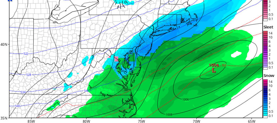
Thursday (Feb 9) high temperatures should be capped in the 30s statewide. Skies should be mostly cloudy. Snow is possible. I will be putting a video out this evening discussing the details of what I’m seeing. Winds are hard to gauge right now as the low’s exact position will determine the cyclonic flow around it. Overnight lows should fall into the teens/20s statewide.
Friday (Feb 10) high temperatures should struggle to escape the 30s statewide. The immediate coast and parts of SNJ would have the best chance at breaking 40. Skies should be mostly sunny. Winds should be light out of the W. Overnight lows should fall back into the teens and 20s statewide.
An early look at the weekend indicates possibly unsettled conditions after a cold and dry Friday. Rain and snow would be possible. We’ll have to revisit this midweek as Thursday now has my full attention. Again, my initial thoughts video will be posted this evening. Be safe! JC
Cover image credit: Tropical Tidbits
Jonathan Carr (JC) is the founder and sole operator of Weather NJ, New Jersey’s largest independent weather reporting agency. Since 2010, Jonathan has provided weather safety and forecasting services for New Jersey and immediate surrounding areas through the web, social media, and app spaces. Originally branded as Severe NJ Weather (before 2014), Weather NJ is proud to bring you accurate and responsible discussions ahead of high-stakes weather scenarios that impact the garden state. All Weather. All New Jersey.™


LOCAL FORECAST | INTERACTIVE RADAR | LATEST NJ WEATHER ALERTS | WEDDING FORECAST| PRIVACY POLICY
© Copyright 2024 Weather NJ LLC. All Rights Reserved.
Some information that can be found on our website is provided by a private weather station and is not an officially recognized station for weather reporting. Though we always strive to achieve accurate reporting for our own use, it is important that you do NOT depend on the data provided here for any purpose.

)