

Watching Coastal Storm (Aug 28-Sept 1)
The start and end of the week look okay. Let’s break it down…
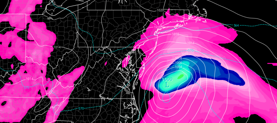
Discussion: An upper level trough will swing through the Great Lakes and interact with both Harvey’s remnants and the coastal energy currently moving up the coast. The coastal energy could become Irma if the NHC is convinced-enough of a tropical core. The system could then interact with the SE US coastline and eventually move over cooler water. Regardless of tropical vs. hybrid-tropical characteristics, the center of circulation (center of the low) should miss to New Jersey’s SE. The outer fringe of the system’s NW quadrant should bring some rain and wind off the ocean to the SENJ coast, possibly a little further into New Jersey. I expect NWNJ would see the least impact. This period would be Tuesday PM hours into early Wednesday AM hours. Minor coastal flooding and beach erosion are possible. The rest of the week that surrounds this coastal storm potential looks beautiful and pleasant.
Monday (Aug 28) high temperatures should reach the mid-70s statewide. Skies should be partly sunny to start but cloud coverage is expected to increase throughout the day, especially heading into the overnight. Winds should be light-to-breezy out of the E/NE felt more along the coast. Overnight lows should fall into the lower-60s for most with NNJ elevations likely dipping into the 50s.
Tuesday (Aug 29) high temperatures should reach the low-to-mid 70s statewide. Skies might be partly cloudy for NWNJ. The rest of New Jersey, especially SENJ, are subject to the outer fringe effects of the passing coastal storm (possibly named Irma). This includes rain and wind with the heaviest wind gusts along the SENJ coast Tuesday evening into early Wednesday morning. Overnight lows should fall into the 50s for most but possibly only the 60s along the coast due to marine influence.
Wednesday (Aug 30) high temperatures should reach the mid-70s statewide. Skies should improve and clear throughout the day after a cloudy start. Winds should subside off the ocean and be light out of the NE for most. Overnight lows should fall into the 60s for most with NNJ elevations and areas away from the ocean likely dipping into the 50s.
Thursday (Aug 31) high temperatures should reach the low-to-mid 80s for most. This looks like the warmest and muggiest day of the week. Skies should be partly sunny with some returning humidity. Winds should be light out of the W/SW. Overnight lows could fall into the 40s for NNJ elevations but probably the 50s for most.

Friday (Sept 1) high temperatures should struggle to escape the 60s for NNJ elevations. The rest of New Jersey should reach the low-to-mid 70s. Skies should be partly sunny with a pleasant feel. Winds should be light out of the NW. Overnight lows should fall into the 40s for NNJ elevations and areas away from the ocean. Even the immediate coast could fall into the 50s.
An early look at the weekend indicates dry and sunny conditions through Sunday with an unsettled Monday to close out the holiday weekend. Let’s take a closer look in a few days. Everyone have a great week and please be safe! JC
Jonathan Carr (JC) is the founder and sole operator of Weather NJ, New Jersey’s largest independent weather reporting agency. Since 2010, Jonathan has provided weather safety and forecasting services for New Jersey and immediate surrounding areas through the web, social media, and app spaces. Originally branded as Severe NJ Weather (before 2014), Weather NJ is proud to bring you accurate and responsible discussions ahead of high-stakes weather scenarios that impact the garden state. All Weather. All New Jersey.™


LOCAL FORECAST | INTERACTIVE RADAR | LATEST NJ WEATHER ALERTS | WEDDING FORECAST| PRIVACY POLICY
© Copyright 2024 Weather NJ LLC. All Rights Reserved.
Some information that can be found on our website is provided by a private weather station and is not an officially recognized station for weather reporting. Though we always strive to achieve accurate reporting for our own use, it is important that you do NOT depend on the data provided here for any purpose.

)