

Wet and Windy Start (Sept 18-22)
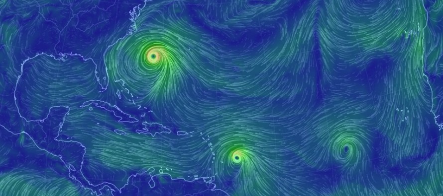
Discussion: You’re probably going to hear about tropical storm watches/warnings issued for the Jersey coast soon. Here are my latest thoughts. Jose will have tremendous influence on our weather for the start of this week. Even though Jose’s center of circulation and strongest core winds are expected to remain offshore (to sleep with the fishes), secondary effects (from NW quadrant of Jose) are expected for New Jersey especially for coastal New Jersey. Our window of most noticeable impact is Monday evening through early Wednesday morning with the meat and potatoes occurring most of Tuesday. Here’s the latest NHC update on Jose, showing the core staying offshore with secondary impacts to the Mid-Atlantic/Northeast US coastlines:
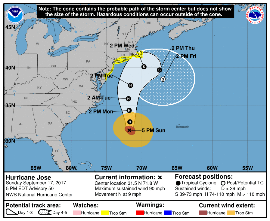
As of right now I’m anticipating possible sustained winds of 20-30mph with gusts possibly exceeding 40mph for the immediate coast. Areas away from the ocean should feel lesser, but still noticeable, winds (sustained 10-20mph with gusts to 30mph). Up to 2-3 inches of rainfall are possible for the eastern half of New Jersey, primarily the immediate coast. Rainfall totals should quickly taper off for the western half of New Jersey, especially west of the Delaware River. Minor-to-moderate coastal flooding is expected. The two high tides on Tuesday should feature the highest water levels of the entire system’s influence. The PM Tuesday high tide should be the higher of the two. Let’s allow for one more high tide to watch Wednesday morning due to draining back bays and creeks into barrier islands. Beach erosion is very much anticipated due to dangerously intensified surf/rip currents. Don’t go in the ocean!
Conditions could begin to subside as early as Tuesday night but definitely by Wednesday morning. Wednesday PM through much of the weekend should then feature much improvement. High pressure will try to build into the region from the NE which should dry things out nicely including the humidity for the weekend.
Lee is expected to fizzle out in the E Atlantic Ocean and is of no concern. If Maria is going to have an impact to New Jersey it would be in the ~September 27 (give or take a day) period. Right now, Maria is expected to hit the northern Lesser Antilles as a hurricane Monday-Tuesday then possibly Puerto Rico as a major hurricane Wednesday-Thursday. Maria would then be near Hispaniola on Friday (Sept 22). Hispaniola has very tall mountains which tend to disrupt tropical cyclones. Therefore estimated track beyond that is highly speculative. East coast landfall has not been taken off the table yet and therefore close tracking will continue. Here is the latest NHC update for Hurricane Maria:

And now, your Monday-Friday Outlook for New Jersey:
Monday (Sept 18) high temperatures should reach the mid-to-upper 70s statewide. Watch out for early AM fog. Skies should be partly sunny NW of I-95 and mostly cloudy SE of I-95. SENJ has the best chance for some early outer-band showers from Jose. Increasing winds out of the E should be felt most along the coast and least away from the ocean. Overnight lows should fall into the 60s statewide as rain chances and wind speeds increase, especially for coastal regions.
Tuesday (Sept 19) high temperatures should reach the low-to-mid 70s statewide. Skies should be mostly cloudy with moderate-to-heavy periods of rain likely. Immediate coastal regions and the general eastern half of New Jersey should see the most rainfall (up to 2-3 inches). Winds should be breezy-to-gusty out of the NE for much of New Jersey. Immediate coastal areas should see the highest sustained winds (up to 30mph) and gusts (possibly exceeding 40mph at times). Rainfall should taper off overnight as winds finish strong out of the N. Minor-to-moderate coastal flooding is possible. Overnight lows should fall into the 60s statewide.
Wednesday (Sept 20) high temperatures should reach the upper-70s/lower-80s statewide. Skies could start cloudy with a few remnant showers but should improve by afternoon/evening hours. Winds should be breezy, starting out of the N early in the day and finishing out of the W maybe SW. Overnight lows should fall into the 60s for most and possibly the 50s for NNJ elevations and interior SNJ pine barrens.
Thursday (Sept 21) high temperatures should reach the upper-70s/lower-80s statewide. Skies should be partly sunny. Winds should be light out of the N/NE. Overnight lows should fall into the 60s for most and possibly the 50s again for NNJ elevations and interior SNJ pine barrens.
Friday (Sept 22) high temperatures should reach near-80 statewide. Skies should be partly sunny with isolated showers and thunderstorms possible during afternoon/early evening hours. Winds should be light out of the N/NE. Overnight lows should fall into the 50s for much of New Jersey with coastal regions possibly hanging in the 60s.
An early look at the weekend indicates mostly sunny, dry and pleasant conditions for both Saturday and Sunday. Let’s revisit this idea in a few days as we watch the tropics continue to evolve. Everyone have a great week and please be safe! JC
Jonathan Carr (JC) is the founder and sole operator of Weather NJ, New Jersey’s largest independent weather reporting agency. Since 2010, Jonathan has provided weather safety and forecasting services for New Jersey and immediate surrounding areas through the web, social media, and app spaces. Originally branded as Severe NJ Weather (before 2014), Weather NJ is proud to bring you accurate and responsible discussions ahead of high-stakes weather scenarios that impact the garden state. All Weather. All New Jersey.™


LOCAL FORECAST | INTERACTIVE RADAR | LATEST NJ WEATHER ALERTS | WEDDING FORECAST| PRIVACY POLICY
© Copyright 2024 Weather NJ LLC. All Rights Reserved.
Some information that can be found on our website is provided by a private weather station and is not an officially recognized station for weather reporting. Though we always strive to achieve accurate reporting for our own use, it is important that you do NOT depend on the data provided here for any purpose.

)