
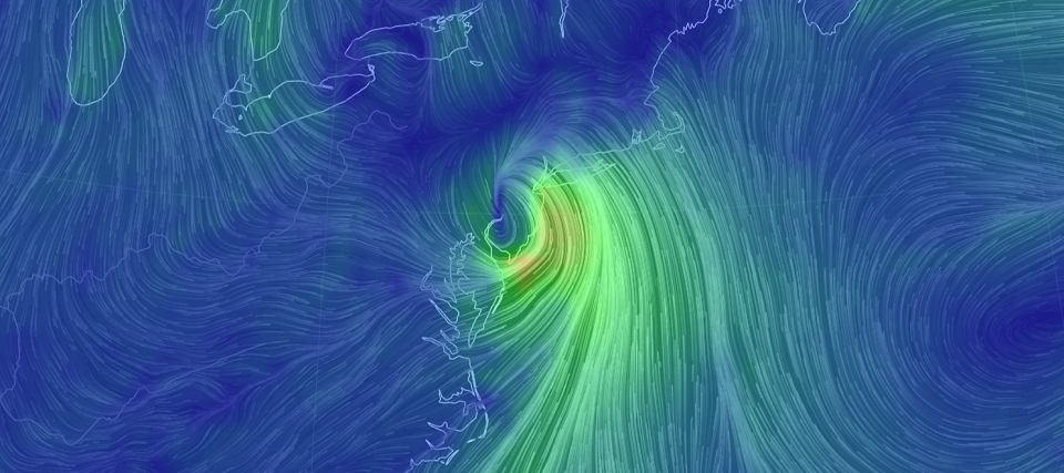
Discussion: Isaias is currently just off the east coast of central Florida as a strong tropical storm. Its steering will now be heavily influenced by the trough spanning from the Great Lakes down through the TN valley. The front of this trough will provide N/NE flow which should take Isaias over NJ after reaching maximum westward track extent tomorrow morning (Monday) somewhere off the FL/GA border. Isaias should then make landfall as either a strong TS (more likely) or weak category 1 hurricane (less likely) somewhere near Myrtle Beach, SC early Tuesday AM before crossing over land through SC, NC, VA, Delmarva and ultimately NJ by Tuesday PM. By the time it passes over NJ it will be moving quickly with the upper-level flow from the front of the trough.
There is some timing disagreement in models which I hope to narrow down for tomorrow’s last update heading into the system. Some models have it arriving in NJ as early as late-Monday night and clearing out to the N/NE by Tuesday night. Other models are slower with arrival by late Tuesday morning and departure by Wednesday morning. So timing is still a bit uncertain but it does look like most of Monday will not be affected. Tuesday should likely feature most of NJ’s impact with conditions possibly spilling over into Wednesday AM. Delmarva should see most impacts between Monday night and Tuesday afternoon.
The modeled track is a little W of when we last looked on Friday. I’m seeing a track either directly over the ECNJ/SENJ coast or just inland of such. In either case, this shifts the heaviest rainfall to the NJTP/I-95 corridor and points NW of such (EPA and NWNJ). The SENJ coast is still in for rainfall just not as much as those on the NW side of the circulation. The heavier rains for interior NJ could easily verify in the inches category. For the SENJ coast, totals might be capped in the 1-3 inch category due to low proximity.
Winds should be very routine for coastal disturbances felt inland. Areas away from the ocean in NJ should expect sustained winds of 15-25mph with gusts of 30-40mph. ECNJ/SENJ coastal areas should take the brunt of the onshore flow with sustained winds of 20-40mph and gusts of 50-60mph. Winds should start ramping up Monday evening, peak on Tuesday (AM or PM still yet TBD) and subside by Wednesday AM.
Coastal flooding should still likely cap-out in the minor category of risk due to the quick moving nature. However, lets allow moderate level instances of tidal flooding in the most flooding-prone areas that normally see water in the streets (from Sandy Hook down through Cape May).
In English: A tropical storm is going to make landfall in SC and move over NJ sometime between Tuesday and Wednesday. Flash flooding is possible from heavy rainfall especially interior NJ away from the ocean. Minor, possibly moderate, levels of coastal flooding are possible for the ECNJ/SENJ immediate coastal areas. Winds could gust 50-60mph along the immediate coast but probably only to 30-40mph for areas away from the ocean. Overall, this seems like a disruptive nuisance event with conditions we’ve seen before. It does not seem like a catastrophic event but we do have to watch the rainfall amounts along the NJTP/I-95 and NW areas. I don’t think the level of rainfall will be as bad as Irene (2011) or Floyd (1999) were but it might get close. I’ll provide another update tomorrow at 5pm as the system is approaching. Hopefully I’ll be able to tighten the timing a bit. Once Isaias moves out by Wednesday AM, the rest of the week doesn’t look too bad. NWNJ should capitalize most from the drier air pulled in behind the system. SENJ could hang on to the humidity. Areas between could be a battleground of humidity. Temps look not as hot as it has been though. Have a great night and please be safe! JC
Download the new free Weather NJ mobile app on Apple and/or Android. It’s the easiest way to never miss Weather NJ content. Our premium services go even further above and beyond at the hyper-local level. Looking for industrial-caliber long-range forecasting data that I personally recommend? Check out WeatherTrends360!


Jonathan Carr (JC) is the founder and sole operator of Weather NJ, New Jersey’s largest independent weather reporting agency. Since 2010, Jonathan has provided weather safety and forecasting services for New Jersey and immediate surrounding areas through the web, social media, and app spaces. Originally branded as Severe NJ Weather (before 2014), Weather NJ is proud to bring you accurate and responsible discussions ahead of high-stakes weather scenarios that impact the garden state. All Weather. All New Jersey.™