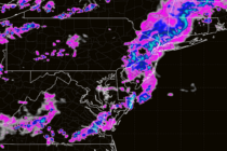
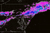
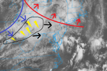
Back to homepage

Latest NJ Weather Alerts

Colder Week. Stormy Weekend.

Colder Week. Stormy Weekend.

🕔15:41, 18.Mar 2024

Discussion: This week is fairly straightforward as a trough swings through the Mid-Atlantic US and holds New Jersey under a colder air mass. The week looks mostly dry with breezy W/NW winds. A few chances for light precip, mainly in

Read Full Article
Mild Weekend Precedes Colder Week

Mild Weekend Precedes Colder Week

🕔00:57, 16.Mar 2024

Discussion: We have a few more mild days this weekend before the pattern changes. Saturday looks like the sunnier drier day. Sunday subject to more clouds and passing isolated showers but far from a washout. The cold frontal passage looks

Read Full Article
Some Nice Stuff this Week

Some Nice Stuff this Week

🕔15:01, 11.Mar 2024

Discussion: I saw a few areas got hit with some nasty snow showers and squalls yesterday…not much accumulation (a coating here and there) but a hard hit of reduced visibility and winds can really pack a punch. I had a

Read Full Article
Wash. Rinse. Repeat. Again.

Wash. Rinse. Repeat. Again.

🕔15:42, 7.Mar 2024

Discussion: The system that brought rain last night and this morning is still clearing out to sea. A few remnant clouds and sprinkles around but for the most part, improvement is expected tonight through tomorrow. Another system then approaches on

Read Full Article
Active Rainy Pattern Continues

Active Rainy Pattern Continues

🕔15:52, 5.Mar 2024

Discussion: It looks like the active synoptic pattern will continue. The above graphic represents total inches of rainfall through this weekend. The active pattern brought New Jersey lots of rain in December, rain and snow events in January/February, and now

Read Full Article
In Like a Lamb

In Like a Lamb

🕔12:31, 1.Mar 2024

Discussion: An E US ridge should dominate the weather pattern for the next week of so (this weekend and next week). This will allow for milder conditions (for this time of year) but also a few rain chances (Saturday and

Read Full Article
Stormy Night Developing

Stormy Night Developing

🕔14:43, 27.Feb 2024

Discussion: This is not a snowstorm article although it’s February and I would love for that to be the case. Instead, this is an article about how rough it could get Wednesday night into early Thursday AM with the expected

Read Full Article
Mild and Unsettled Pattern

Mild and Unsettled Pattern

🕔14:29, 26.Feb 2024

Discussion: We’ve definitely left the E US trough pattern and will now settle into mostly an E US ridge pattern with a few troughs just grazing NJ with it’s S tip. This will force most low pressure systems to track

Read Full Article
Rain Clears for a Cold Dry Weekend

Rain Clears for a Cold Dry Weekend

🕔14:57, 23.Feb 2024

Discussion: A trough will swing through the E US this weekend after this evening’s rain moves out. This will keep the weekend colder for NJ with the coldest point likely occurring just before sunrise Sunday morning. The trough then moves

Read Full Article
Colder Dry Start. Milder Wet Finish.

Colder Dry Start. Milder Wet Finish.

🕔14:30, 19.Feb 2024

Discussion: We’re still dealing with a colder air mass that was pulled down behind Saturday morning’s system. The sun angle, however, is climbing daily and really starts to show its ugly face (to the snow lover) from now through the

Read Full Article