Stormy Start. 4th Looking Good!
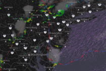
Discussion: This morning there was a stationary boundary draped across SNJ which is now advancing northward through CNJ as a warm front. This is the culprit for the current CNJ/SNJ storms firing along the extended Mason Dixon line and points