
Discussion: Just a few small tweaks to a final forecast heading into the Thursday-Friday event that we’ve been tracking. Yesterday’s article covered all the principal dynamics involved and those have not changed: Primary low cuts into the Great Lakes, encounters the block, then spawns a secondary/coastal low for the Mid-Atlantic US that keeps precipitation around into Friday.
NWNJ (N of I-80 and NW of I-287) should continue to expect the wintriest outcome while the lower 2/3 of New Jersey sees a mostly rain solution. About the only thing I would like to point out is that there will be high pressure N of Maine (in SE Canada) that will be feeding cold air into the system from the NE. This likely won’t be enough to make a difference in snow accumulation extent further southward into New Jersey. But it might allow for an icier situation at the onset of precipitation tomorrow (by late Thursday morning).
Most of New Jersey is going to drop into the 20s tonight. It’s going to feel like snow. Even the SENJ coast should dip down to freezing or slightly below overnight tonight. So we’re going to have a cold setup to start before warm air advection off the ocean takes temps above freezing for the coastal plain. Warm ocean air always wins out for NENJ/CNJ/SNJ especially this time of year. But the transition from below-freezing to above-freezing could create more of a wintry headache for maybe areas along I-95/NJTP. Just something to consider for tomorrow’s AM commute.
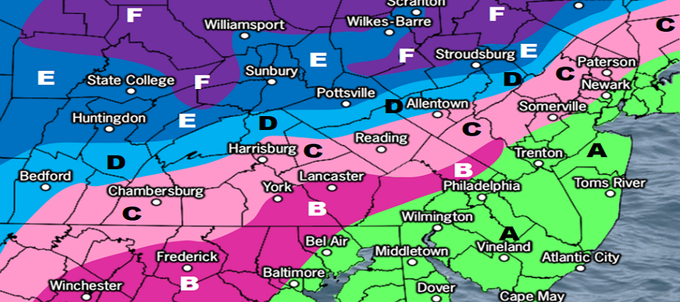
Eventually, by tomorrow afternoon/evening, the snow/rain line should advance northward (from I-95) and confine to that N of I-80/NW of I-287 area of NJ. The tip of NWNJ should see the most accumulating snow with a sharp gradient immediately to the SE. You could see a few inches of snow drop to just plain rain in less than a 20-mile gradient. Here’s our last snow map before heading in:
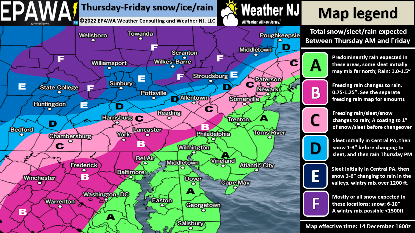
Please click here for full resolution snow map.
In English: A mix of snow/ice/rain should move into NJ from the SW tomorrow morning (Thursday) by noon. A snow rain line should set up across NNJ again and keep the wintry stuff N of I-80 and NW of I-287 after a possible icier start for areas closer to I-95. Areas S of I-80 and SE of I-287 should expect a mostly rain solution of maybe 1-2 inches of rain. It all clears out by Friday afternoon and we then enter a cold period and pattern starting this weekend. I’m watching Dec 23 specifically for the next wintry signal but at this time I can’t promise anything S of the current NWNJ areas seeing snow. I’ll detail this more in the weekend outlook. But for now, best of luck with the Thursday-Friday system. Have a great rest of your Wednesday and please be safe! JC
Premium Services
KABOOM Club offers inside info forecast discussion, your questions answered, and early storm impact maps (ahead of the public). At 99 cents per month, it’s an extremely feasible way to show support.
My Pocket Meteorologist (MPM), in partnership with EPAWA Weather Consulting, offers professional/commercial interests, whose businesses depend on outdoor weather conditions (snow plowing, landscaping, construction, etc.), with hyper-local text message alerts/forecasts and access to the MPM premium forum—the most comprehensive and technical forecast discussion available for PA and NJ.


Jonathan Carr (JC) is the founder and sole operator of Weather NJ, New Jersey’s largest independent weather reporting agency. Since 2010, Jonathan has provided weather safety and forecasting services for New Jersey and immediate surrounding areas through the web, social media, and app spaces. Originally branded as Severe NJ Weather (before 2014), Weather NJ is proud to bring you accurate and responsible discussions ahead of high-stakes weather scenarios that impact the garden state. All Weather. All New Jersey.™