
Discussion: Our weak anafrontal rain-to-snow system has moved out and we’ll now be cold tonight through tomorrow. Moving forward I’m watching two specific storm signals. You may remember be talking about a December 15th storm signal and how the roller coaster of temperatures would likely produce some type of disturbance(s). The logic weeks ago was the fluctuation in the jet stream despite a zonal pattern. Now that we are closer to the period the signal has split into two separate events. The first is December 14th and the second is ~December 17th.
December 14th looks warm, rainy and windy. There will not be an adequate cold air mass in-place to support wintry precipitation. Therefore we’re likely dealing with rain from start to finish. A primary low will track into the Great Lakes just before this system arrives and hoist a warmer air mass across the E US. We do however have some strong dynamics aloft with a sub-1000mb low involved once spawned near ~NJ/Delmarva. This should produce periods of heavy rainfall and gusty winds. The rain and wind associated with this system should arrive this Friday night and clear out by Saturday night with the meat and potatoes of impacts occurring this Saturday morning. There is no blocking in the Greenland region so it should come and go without being a multi-day event. Again…no snow with this one just rain and wind. I’ll cover it more in tomorrow’s weekend outlook.
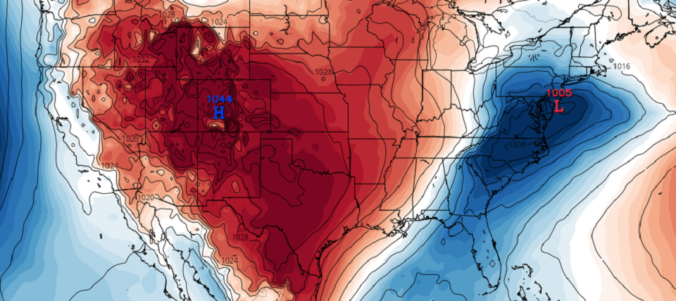
The next and more distant storm signal is what I am calling the Hoth System because it would occur the week that Star Wars The Rise of Skywalker releases (next week). Right now the timing is targeting late Monday night (Dec 16) through early Wednesday morning (Dec 18) with Tuesday (Dec 17) the meat and potatoes of impacts. Like all other systems so far this December we are likely lacking the cold air mass to support snow for all of NJ. This one however should be wintry for at least NNJ. The Euro is on board with this. The GFS is not. But from this range I am only paying attention to the signal supported by general ensemble guidance. The image of this article represents mean surface pressure on the ECM EPS which is some of the most accurate data there is in weather modeling. We need to see the first signal clear out this Saturday PM before properly assessing this second signal for surface impacts. If this signal is still screaming Saturday night then it will be time to track seriously.
It is absolutely way too far away to take seriously but a third signal is emerging just before Christmas. Just a signal. I won’t even discuss surface expectations on this one only that the pattern would support it and there’s a weak signal on the ensembles.
In English: We’re cold tonight and tomorrow. Then we warm for a rain storm this Friday night into Saturday (heavy rain and gusty winds possible). Temperatures should then drop again behind the rain storm for Saturday night through Sunday and into Monday. Then we start paying attention to the Tuesday (December 17) storm signal as our next wintry potential. Right now NNJ is favored for snow with SNJ a little too warm. As I said in the discussion above let’s get through this first rain storm signal early this weekend before putting too much faith in what it’s going to do next Tuesday at the surface. Tomorrow we’ll return back to your regularly scheduled weekend outlook which will go into detail about the weekend rain storm and cover any new developments or trends for next week’s wintry signal.
Download the new free Weather NJ mobile app on Apple and/or Android. It’s the easiest way to never miss Weather NJ content. Our premium services go even further above and beyond at the hyper-local level. Looking for industrial-caliber long-range forecasting data that I personally recommend? Check out WeatherTrends360! Visit the Weather NJ Kaboom Shop for hoodies, tees and infant onesies.


Jonathan Carr (JC) is the founder and sole operator of Weather NJ, New Jersey’s largest independent weather reporting agency. Since 2010, Jonathan has provided weather safety and forecasting services for New Jersey and immediate surrounding areas through the web, social media, and app spaces. Originally branded as Severe NJ Weather (before 2014), Weather NJ is proud to bring you accurate and responsible discussions ahead of high-stakes weather scenarios that impact the garden state. All Weather. All New Jersey.™