
After reviewing the latest model guidance and taking into consideration the current synoptic pattern, I’m prepared to issue the following snow map for this Wednesday’s clipper snow event:
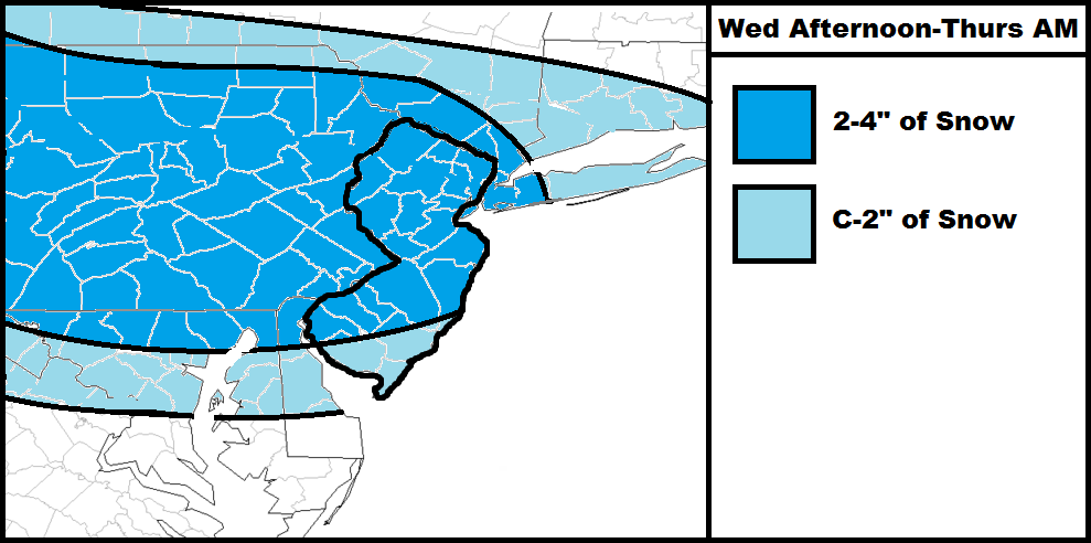
The general idea here is that weak low pressure will dive into the region from the W/NW and link up with weak low pressure off the coast of Delmarva. The precipitation from both disturbances will combine and form a swath across the northern mid-Atlantic US where it’s cold enough to support snowfall. The timing for this would be late Wednesday morning through early Thursday AM (which I’ll probably narrow a bit more tomorrow after reviewing fresh guidance).
Surface temperatures will be the only level that could be at or slightly above freezing and likely only for SENJ. Eventually all parts of the state will drop below freezing but some snow may fall before that happens and possibly even some rain at first. For that reason, snowfall accumulations in SENJ would be on the lower side of the system’s general performance. Should the coastal development be stronger, accumulations could exceed 4 inches locally in the darker blue area. There’s limited supporting guidance for that but I’ve seen it happen before numerous times. Otherwise nothing crazy is expected…a 1-3″/2-4″ widespread snow event.
In English: Expect light-to-moderate snowfall between late Wednesday AM and early Thursday AM hours with a coating to light accumulations likely throughout the state. Just a small chance of over-performance that we won’t be able to detect until now-casting time. Be safe! JC


Jonathan Carr (JC) is the founder and sole operator of Weather NJ, New Jersey’s largest independent weather reporting agency. Since 2010, Jonathan has provided weather safety and forecasting services for New Jersey and immediate surrounding areas through the web, social media, and app spaces. Originally branded as Severe NJ Weather (before 2014), Weather NJ is proud to bring you accurate and responsible discussions ahead of high-stakes weather scenarios that impact the garden state. All Weather. All New Jersey.™