
Discussion: This article will first cover the Wednesday-Thursday snow-to-rain event before we dive into some near-future signals I’m seeing. What we have been referring to as storm 1 arrived yesterday (as snow for NWNJ), precipitated overnight as mostly rain, and then changed back to snow today for NNJ and some CNJ areas. The associated low for storm 1 is now near the tip of Cape Cod and precipitation is pulling away with it. We’ll now be left in a colder NW flow pattern behind the departing low for tonight through the first half of Wednesday. Not brutal cold but colder.
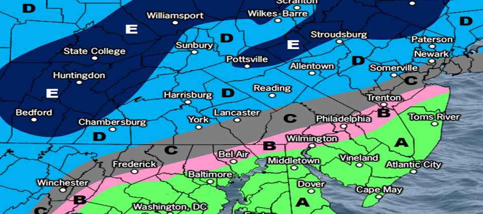
On Wednesday, a low will track from Texas over the E Great Lakes and ultimately into SE Canada by Tuesday…a low track well to the NW of NJ. This is what we’ve been referring to as storm 2. Typically a NW track like this means no chance of snow for NJ unless there is cold ahead of the warm front and precipitation overrunning the warm front. In the case of this Wednesday we’re going to have a high siting over the interior Mid-Atlantic. This high will slowly backpedal into the NE US/SE Canada as the low follows it. The key takeaway is that the high will be putting up a wall of air cold enough for snow before it retreats backwards. The overall mid-to-upper flow pattern is favorable for producing overrunning precipitation ahead of the warm front. We suspect this from the suggested higher levels of frontogenesis. With all of this said, at least NWNJ, possibly lower areas in NNJ/CNJ are in for a front-end snow thumping Wednesday between late-morning and afternoon hours. By late-afternoon/early-evening, the warm front will push through from the SW and change all areas to rain. At that point we’ll be in the warm sector of the cyclone with above-freezing air streaming in off the Atlantic Ocean out of the SE. That will likely keep the rest of the system rain for all areas barring any ending changeover’s like today in NNJ.
A few things to keep in mind. Even though all rain is eventually expected for all areas (by Wednesday night), there could be a light-to-significant snow accumulation, before the changeover, that could affect Wednesday PM commuting/school bus hours. We currently believe this is possible for at least NWNJ (N of I-78/NW of I-297) but possibly all the way down to the NJTP/I-95 corridor. At this point areas SE of NJTP/I-95 appear too warm for any accumulations. But this system appears colder than the last few which have brought wintry precip to NWNJ elevations only. Another thing to consider is compaction and melting. If 3-6 inches of snow falls, there might only be 2-4 inches of snow once the snow settles and melts a little with rain. It’s honestly leading towards more of s slushy event despite starting powdery. With all of this said, here’s our initial snow map for this Wednesday-Thursday:
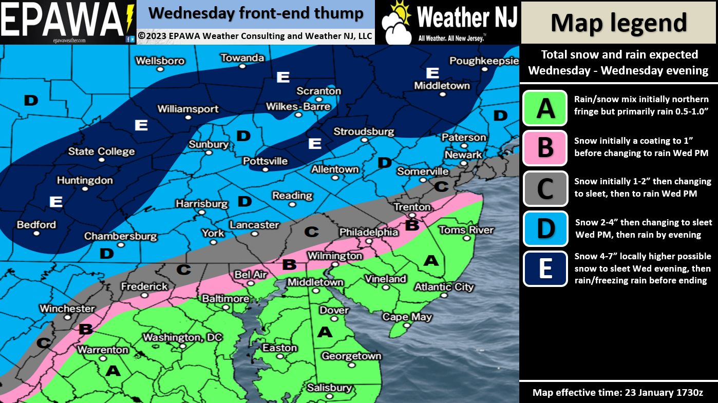
Please click here for full-resolution snow map!
Now let’s talk about the future. The Wed-Thurs system will depart and bring back colder NW flow for Thursday through at least Saturday morning. We might moderate slightly Sunday-Monday but then an active storm track is setting up offshore. Not lows passing to our NW but rather to our SE. A Miller-A train of energy. A Miller-A storm is one that originates in/near the Gulf of Mexico and rides up the east coast. From about Jan 31 to Feb 8, there are several coastal storm signals which again, represents an active expected pattern. We likely won’t have Arctic air over all of NJ but at least a lobe of it to our NW or just into NJ that could mix in and finally bring snow temps as far S as SNJ. I’m becoming more optimistic for this period (Jan 31-Feb 8) each day we get closer to it. By no means will it be a return to a pattern like 2009-2010, 2010-2011, 2013-2014, or 2018. But certainly steps towards it from where we’ve been.
In English: Colder and tranquil tonight into Wednesday morning. Snow to rain to the NW of NJTP/I-95 Wednesday afternoon. All rain SE of such. Precipitation ends Thursday morning likely as rain before temps drop. Then a colder Thurs-Sat, slightly moderated Sun-Mon, leading up to a colder active period next week. I suspect there will be articles written about next week with a few different snow possibilities in the general Jan 31-Feb 8 period. Enjoy the rest of your Monday and please be safe! JC
Premium Services
KABOOM Club offers inside info forecast discussion, your questions answered, and early storm impact maps (ahead of the public). At 99 cents per month, it’s an extremely feasible way to show support.
My Pocket Meteorologist (MPM), in partnership with EPAWA Weather Consulting, offers professional/commercial interests, whose businesses depend on outdoor weather conditions (snow plowing, landscaping, construction, etc.), with hyper-local text message alerts/forecasts and access to the MPM premium forum—the most comprehensive and technical forecast discussion available for PA and NJ.


Jonathan Carr (JC) is the founder and sole operator of Weather NJ, New Jersey’s largest independent weather reporting agency. Since 2010, Jonathan has provided weather safety and forecasting services for New Jersey and immediate surrounding areas through the web, social media, and app spaces. Originally branded as Severe NJ Weather (before 2014), Weather NJ is proud to bring you accurate and responsible discussions ahead of high-stakes weather scenarios that impact the garden state. All Weather. All New Jersey.™