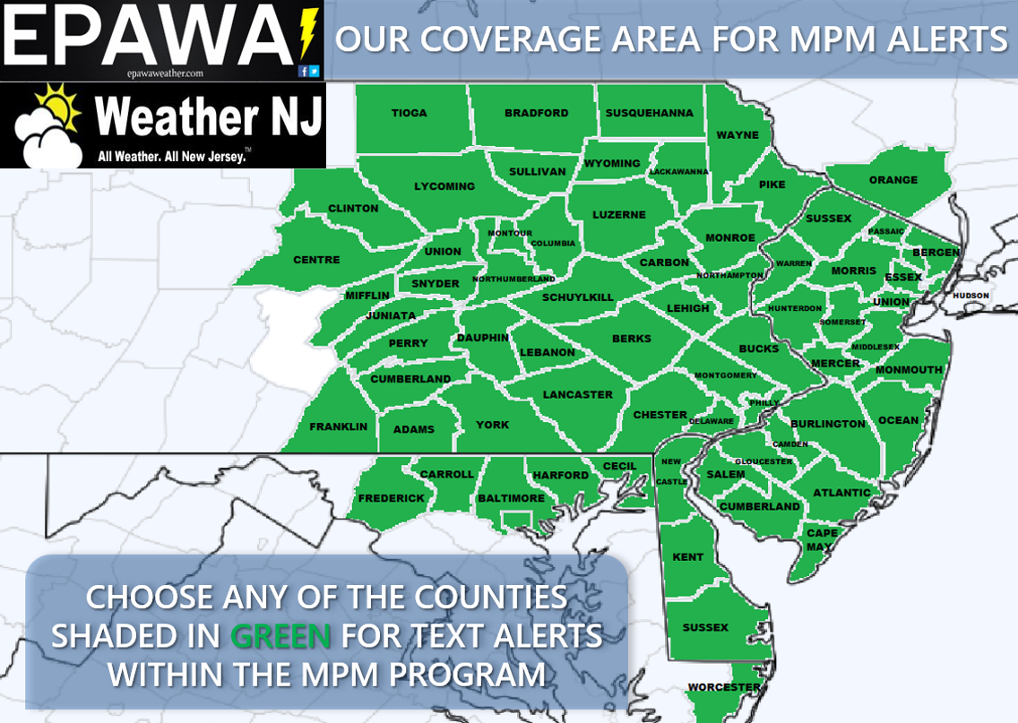
Weather Alerts Service
The My Pocket Meteorologist™ Weather Alert Service can give you an early warning for any potential weather systems moving into your hyper-local area. Not only will this include advanced notice the night before, but also short-term “hour-of” alerts as well. You will receive advanced notice of:
- Winter Storms – Up to 4 days’ notice with daily updates thereafter leading up to the storm, and updates with any changes to previous text forecasts as needed during the storm until storm passes.
- Lighter snow events (less than 3″) – Up to 2 days’ notice with with daily updates thereafter leading up to the storm, and updates with any changes to previous text forecasts as needed during the storm until storm passes.
- Ice Road Conditions – Any threat of ice
- Snow Consistency – Wet vs Fluffy
- Heavy Rain – Up to 2 days’ notice of rain totaling over .50” within a 12 hour period.
- Thunderstorms – Up to 2 days’ notice of strong/severe thunderstorms and real-time alerts for lightning.
- Wind – 1 day notice for wind gusts 40mph or greater.
- Dense Fog – 1 day notice of fog that will limit visibility under ¼ mile for more than 3 hours.
- Tropical Systems – Up to 8 days’ notice of any impact on your county.
Great for everyone from snow removal services, school districts, and roofers to every-day commuters and those wanting the most accurate information possible! We break down each county even further to the hyper-local level taking into consideration the various micro-climates that produce different conditions within each county. For example: Coastal areas of a county behave different than interior areas of a county. Higher elevations of a county behave differently than lower elevations of a county. We’ll make sure you know exactly what you’re in store for—and that you’re NOT just seeing a single weather symbol representing the forecast for the entire day.
If you’re interested in saving some money we’re running winter specials that cover the entire snow season from now through March 31 (or last snow).
*Weather alerts are only sent to your phone between the hours of 9am and 9pm for real-time storm alerts. We will never bother you or send a text past 9pm unless it is an emergency situation, such as an imminent tornado.


Daily Forecast Service
Perfect for the every-day weather curious person looking for more than your average news forecast, the MPM Daily Text Forecast Option provides the NEXT DAY forecast for your county, sent between 5-8PM the night before! This service:
- Accurately depicts when snow or rain starts and stops, and narrow time windows of when showers and thunderstorms are possible.
- Includes high and low temperatures, and threats for frost and freeze—Excellent for snow plow and agricultural industry.
- Provides expected wind speed, direction and maximum gust potential.
- Is sent every day, 365 days a year

Premium Weather Forum
Our premium forum is managed and contributed to by EPAWA and Weather NJ meteorologists/forecasters. No matter what the weather, we give you the most comprehensive in-depth advanced information for the area that you care about—the local area we specialize in. From human analysis that you won’t find anywhere publicly, we explain the hows and whys of weather systems, how it may impact the region by individual area, and discuss with the members our interpretations of model guidance with impending storms affecting our region. As a member, you get:
- Exclusive access to Seasonal Outlooks not shared publicly
- Early access to Winter snow maps before the public, including advanced discussion not shared with the public
- Early access and model analysis for severe weather events, including our proprietary severe charts for your specific location
- Frequent updates on all major weather systems affecting our region
- Long range outlook updates Monday, Wednesday and Friday
- In-depth model analysis (run-by-run discussion leading up to and during high stakes weather events)
- Ask A Meteorologist
- Short, Medium & Long Range weather discussions
- Storm observations


