

Active Rainy Pattern Continues
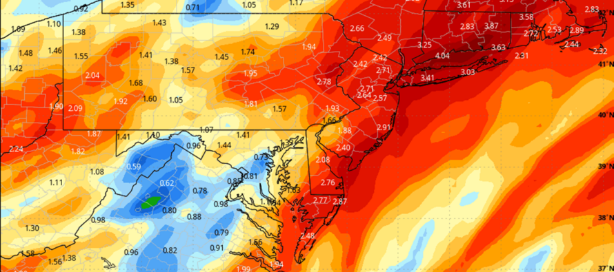
Discussion: It looks like the active synoptic pattern will continue. The above graphic represents total inches of rainfall through this weekend. The active pattern brought New Jersey lots of rain in December, rain and snow events in January/February, and now more rain in the first third of March. Regardless of precipitation type, it seems like we’ve had a synoptic system provide precipitation almost every 3-6 days since Thanksgiving weekend (give or take some days). Upper-level data is suggesting prolonged periods of E US ridging checkered with transient troughs…about what you expect to see as winter transitions to spring though maybe just a little bit more frequency of the cycles.
Today’s rain is winding down and we should catch a break from the rain this evening/overnight. Rain should then return by late tomorrow (Wednesday) morning for most of New Jersey and last through at least Thursday morning, maybe afternoon. This will correlate with a weak low tracking N along the coast. Another break is expected from Thursday evening through most of Friday. Friday might be the next time most NJ areas see a clear shot of sun.
The jury is still out on when the rain will start Saturday. But more rain should move in at some point between late morning and evening. This will be a double-barrel surface low setup for the E US Saturday PM-Sunday with a rapidly deepening upper-level low following for Sunday-Monday. The first part of the system (double-barrel surface lows) should produce a rainy outcome for NJ between whenever it starts Saturday PM and when it clears out Sunday morning. This will be the meat and potatoes of the precipitation and only has a small chance to fall wintry for only the highest Sussex County elevations…and I wouldn’t hold my breath on that. If it’s going to snow at all this weekend, it would be the second part of this weekend’s setup…Sunday into Monday in the form of lake effect flurries/snow showers/streamers/etc. Accumulations would be little-to-none with the best chance for such occurring Sunday overnight into Monday. But the Great Lakes surfaces are melting which means moisture tap via evaporation is on the table with NW winds. And we will have a colder air mass moving in as the upper-low deepens over the lake effect snow zone.
The transient colder period, behind the departing/consolidating lows and under the upper low, should then last until about Tuesday. Another ridge then forms and likely lasts through next weekend. That will leave the final out of the 9th inning (of this winter’s baseball game) to the period between March 17-23. That period is too far out to forecast for, but it would theoretically be when another transient 2-3 day trough pushes through our region. Again, the final chance. If on March 23, the following 7 days look mild then that will be the ballgame (April 1). April snow is unicorn rare especially for the coastal plain. I cannot speak about April like I can about March regarding snow possibilities. Yes I know there are some isolated historic examples but nowhere near the stats of March.
In English: Expect rain through at least Thursday morning. A break tonight and a break Thursday PM through Friday but then it’s back for Saturday PM into Sunday. The above graphic represents total inches of rainfall through this weekend. A very active pattern. Temps should stay very close to 50 for most areas through Saturday night. As conditions turn colder, snow is possible Sunday into Monday in the form of lake effect stuff but would yield little-to-no accumulations if it even happens. Daytime snow would melt on contact, due to surface temps being way above freezing. Sunday night snow would have a better chance of sticking with colder surface temps, especially NWNJ, but would still fight inhibiting factors of climatology this time of year. The more impactful weekend conditions are rain and light/moderate winds Saturday PM into Sunday IMO. See last paragraph above on discussion about the rest of this winter. Have a great week and please be safe! JC
Premium Services
KABOOM Club offers inside info forecast discussion, your questions answered, and early storm impact maps (ahead of the public). At a buck per month, it’s an extremely feasible way to show support.
My Pocket Meteorologist (MPM), in partnership with EPAWA Weather Consulting, offers professional/commercial interests, whose businesses depend on outdoor weather conditions (snow plowing, landscaping, construction, etc.), with hyper-local text message alerts/forecasts and access to the MPM premium forum—the most comprehensive and technical forecast discussion available for PA and NJ.
Get your KABOOM Inside Out pajamas and more at the KABOOM shop!
Jonathan Carr (JC) is the founder and sole operator of Weather NJ, New Jersey’s largest independent weather reporting agency. Since 2010, Jonathan has provided weather safety and forecasting services for New Jersey and immediate surrounding areas through the web, social media, and app spaces. Originally branded as Severe NJ Weather (before 2014), Weather NJ is proud to bring you accurate and responsible discussions ahead of high-stakes weather scenarios that impact the garden state. All Weather. All New Jersey.™


LOCAL FORECAST | INTERACTIVE RADAR | LATEST NJ WEATHER ALERTS | WEDDING FORECAST| PRIVACY POLICY
© Copyright 2024 Weather NJ LLC. All Rights Reserved.
Some information that can be found on our website is provided by a private weather station and is not an officially recognized station for weather reporting. Though we always strive to achieve accurate reporting for our own use, it is important that you do NOT depend on the data provided here for any purpose.
