

Aug 17: Some Relief Today. More Next Week
Most will see a break in the oppressive heat and humidity today and tomorrow. We’ll then return to swampy conditions for the weekend followed by cool refreshing air next week.
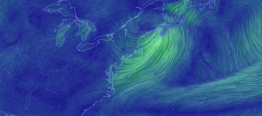
The warm front passed through NJ two nights ago from S to N, bringing warm and muggy southerly flow with it. We were then placed in the warm sector of the synoptic low that tracked through the Great Lakes into New England. Yesterday’s pre-frontal trough in the warm sector ended up producing storms across NWNJ/NNJ late-yesterday afternoon into early evening hours. CNJ saw storms overnight. SNJ featured air too-stabilized by marine influece to sustain thunderstorm development. A sea breeze front backed in yesterday afternoon and further reinforced the marine influence. Thunderstorms need a warmer lower-layer of the atmosphere to sustain negatively buoyant air parcels (mostly caused by diurnal heating). When a sea breeze front backs in, if it isn’t enough to trigger convection, it puts cooler air at the surface and completes the marine inhibition. That’s what most of CNJ/SNJ/SENJ saw yesterday ahead of the pre-frontal trough.
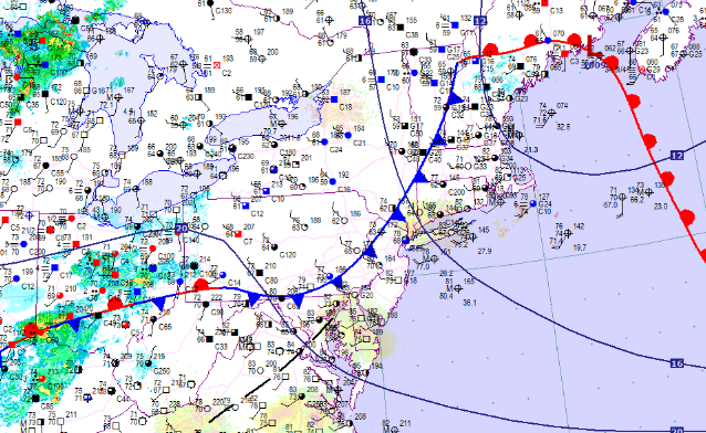
We’re now dealing with the cold frontal passage today. Remember, cold fronts this time of year have much more impact on dew points than temperatures. While we’ll all still reach the upper-80s today, possibly even 90 in some places, we’ll see dew points stabilize into the 60s for all except extreme SNJ/SENJ which will make a difference in feel. We’ll also see a wind direction switch today to the W/NW. Again, this flow is still pulling from warm air but from a much drier source. I wouldn’t call today total relief but definitely some relief. Due to the cold front moving slower from NW to SE, the Cape May/extreme SENJ area could hold onto elevated humidity levels the longest. This could also pop some storms in the SNJ/SENJ area given the proximity to the frontal boundary. With that said, it might be until next week that even extreme SENJ sees relief. For everyone else, the slightly drier and breezier conditions should last into Thursday.
From the second half of Thursday through the weekend, we’ll see the southerly flow return which will bring back humidity to all for the weekend. I’m monitoring a powerful cold frontal passage in the Sunday-Monday period which will then bring the most refreshing air of the summer to the region for next week.

In English: The northern 2/3 of New Jersey will see relief today in the form of lower humidity and W/NW flow, despite temperatures still reaching/approaching 85-90 in many places. The southern 1/3 of New Jersey could hang onto the humidity but with temperatures not as hot as recent times. This is because of the cold front’s deceleration from NW to SE. Therefore, popup storms are possible in extreme SNJ/SENJ (closer proximity to front) while mostly everyone N of that sees relief. The entire state should then see the return of humidity for the weekend followed by extreme relief next week as a strong cold front fully pushes through the entire state, not the hung up kind like today. Even though the weekend looks humid, I doubt we’ll see temperatures like last weekend. I’ll have the full and detailed weekend outlook posted tomorrow evening. Thanks and be safe! JC
Jonathan Carr (JC) is the founder and sole operator of Weather NJ, New Jersey’s largest independent weather reporting agency. Since 2010, Jonathan has provided weather safety and forecasting services for New Jersey and immediate surrounding areas through the web, social media, and app spaces. Originally branded as Severe NJ Weather (before 2014), Weather NJ is proud to bring you accurate and responsible discussions ahead of high-stakes weather scenarios that impact the garden state. All Weather. All New Jersey.™


LOCAL FORECAST | INTERACTIVE RADAR | LATEST NJ WEATHER ALERTS | WEDDING FORECAST| PRIVACY POLICY
© Copyright 2024 Weather NJ LLC. All Rights Reserved.
Some information that can be found on our website is provided by a private weather station and is not an officially recognized station for weather reporting. Though we always strive to achieve accurate reporting for our own use, it is important that you do NOT depend on the data provided here for any purpose.
