

Dec 5: Another System Approaches
Tuesday could feature moderate-to-heavy rainfall statewide and possibly more snow for the higher elevations of NWNJ. Let’s break it down…
Low pressure is forming in the Gulf of Mexico and will track to the Ohio Valley. It should then transfer to a coastal low off the OBX/VA Beach region and pull away S of the 40N/70W benchmark. This should drag a decent precipitation shield over our region from SW to NE between noon tomorrow and midnight tomorrow night. The mid-to-upper levels are marginal in temperature so most wintry precipitation is dependent on higher intensity bringing down colder air aloft. Heavier intensity is modeled so we’ve issued the following collaborative impact map:
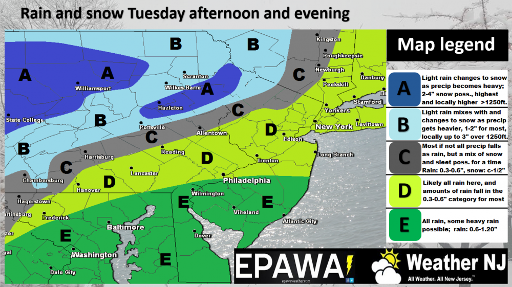
Click here to view FULL RESOLUTION map
In English: Expect rain to spread through New Jersey tomorrow from SW to NE anytime after late morning. It should rain heaviest between afternoon and evening hours before tapering off around midnight, give or take a few hours. NNJ/NWNJ areas should refer to the map above for wintry precipitation possibilities. For everyone else, which are most, this is another cold rain event like this morning was. I would expect tomorrow’s PM rush hour to be slow moving. Thursday we start to drop as the coldest air of the second half of 2016 arrives and lasts through the weekend. Be safe! JC
Jonathan Carr (JC) is the founder and sole operator of Weather NJ, New Jersey’s largest independent weather reporting agency. Since 2010, Jonathan has provided weather safety and forecasting services for New Jersey and immediate surrounding areas through the web, social media, and app spaces. Originally branded as Severe NJ Weather (before 2014), Weather NJ is proud to bring you accurate and responsible discussions ahead of high-stakes weather scenarios that impact the garden state. All Weather. All New Jersey.™


LOCAL FORECAST | INTERACTIVE RADAR | LATEST NJ WEATHER ALERTS | WEDDING FORECAST| PRIVACY POLICY
© Copyright 2024 Weather NJ LLC. All Rights Reserved.
Some information that can be found on our website is provided by a private weather station and is not an officially recognized station for weather reporting. Though we always strive to achieve accurate reporting for our own use, it is important that you do NOT depend on the data provided here for any purpose.
