

Discussing the Rest of March


It’s time to harness WeatherTrends360 technology and look at the rest of March 2019. WeatherTrends360 algorithms are documented with an 84% verification rate and are based on oceanic water cycles, time table series and very complex mathematics. The best takeaway from this data are general trends (cool vs warm, rainy vs dry, etc). I’m always hesitant to forecast specific surface conditions (rainfall amounts, snowfall amounts, winds, etc) beyond the 7 -day forecasting period. But temperature and precipitation trends are what WeatherTrends360 does best with their proprietary mathematical analysis derived from over 150 years of reactive pattern data. For this reason, let’s call this a long-range discussion of expectations rather than a locked-in long-range forecast.
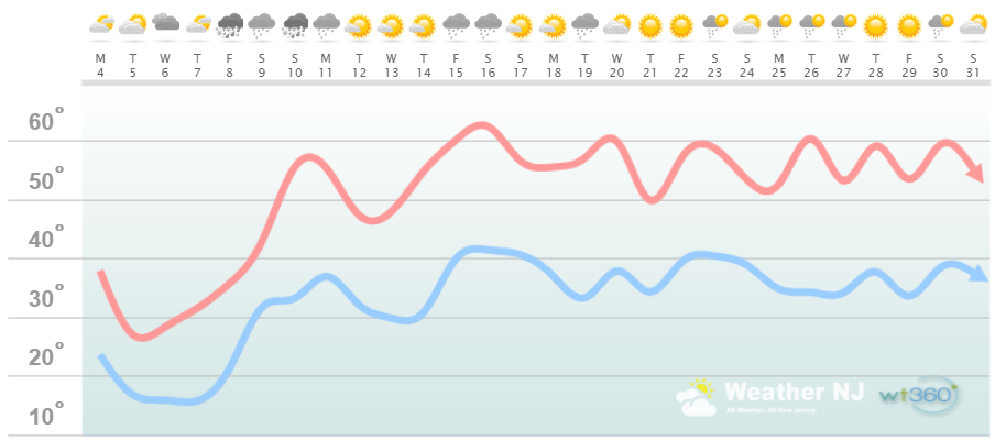
The following diagram is calculated for the meat and potatoes of New Jersey in general. Please keep in mind that micro-climate influences can vary. NWNJ elevations, for example, will likely end up ~5-10 degrees colder than what is shown. SENJ, especially the immediate coast, will likely end up ~5-10 degrees warmer than what is shown. But for most of New Jersey between…this diagram should suffice for the general idea.
Discussion: The strong zonal Pacific Jet has taken its toll on Winter 2018-2019 for New Jersey. We saw seasonal bookend systems (November and March) but we failed to see a major snow storm hit statewide in the core peak snow season. We are certainly running out of time. I like to use the analogy that we’re in the bottom of the 9th inning of winter. Sure there will be transient progressive upper-level troughs that could chill the region down for 1-3 days. And snow showers and squalls are possible through March even into April. Therefore it’s foolish to say we’re finished with snow on March 4. After all winter ends on March 19. I just don’t see anything major on the near-horizon snow storm-wise.
There are two storm signals. One is this Friday night (March 9) and the other is March 18-20. Right now they just don’t have the sauce to support major snowfall but I’ll keep close tabs on them. This Friday looks like a quick snow to rain changeover for NNJ with CNJ and SNJ likely rain only. The March 18-20 signal is simply too far away to analyze with detail.
As far as higher-level temperature trends all areas should turn the corner towards spring from March 12-forward. This week is going to be cold but that should be it for any level of brutal March cold. After March 12 we should be looking at NNJ seeing 40s and 50s and CNJ/SNJ seeing 50s and 60s. Again don’t count out the possibility for a transient period of cold but for the most part we’re warmer March 12-forward. This weekend looks the most unsettled of all weekends in March with the Friday night-Saturday morning synoptic signal and a cold frontal passage Sunday.
In English: This week should be cold and dry…the coldest week in March. In the second week of March we should transition to a warmer spring-like pattern. The birds and sun-angle will remind you of this each morning especially after we set the clocks forward. After about March 12 we should be in a sustained spring pattern with only transient cold periods possible and reducing in duration as time moves forward. No major snow storms are showing on the horizon however two storm signals are that I will watch (March 8-9 and March 18-20). These are most likely rain storm signals not snow storm signals but I will let you know as we closer approach. I’ll heavily track and blog about anything within a 7-day forecasting period. For beyond 7 days I can’t recommend WeatherTrends360 enough. Everyone have a great rest of your March and please be safe! JC

Jonathan Carr (JC) is the founder and sole operator of Weather NJ, New Jersey’s largest independent weather reporting agency. Since 2010, Jonathan has provided weather safety and forecasting services for New Jersey and immediate surrounding areas through the web, social media, and app spaces. Originally branded as Severe NJ Weather (before 2014), Weather NJ is proud to bring you accurate and responsible discussions ahead of high-stakes weather scenarios that impact the garden state. All Weather. All New Jersey.™


LOCAL FORECAST | INTERACTIVE RADAR | LATEST NJ WEATHER ALERTS | WEDDING FORECAST| PRIVACY POLICY
© Copyright 2024 Weather NJ LLC. All Rights Reserved.
Some information that can be found on our website is provided by a private weather station and is not an officially recognized station for weather reporting. Though we always strive to achieve accurate reporting for our own use, it is important that you do NOT depend on the data provided here for any purpose.
